Leen Helmink Antique Maps & Atlases
www.helmink.com
van Keulen
Nieuwe Paskaard Inhoudende t'Noorder ...
Certificate of Authentication
This is to certify that the item illustrated and described below is a genuine antique
map, print or book that was first produced and published in 1701, today 323 years ago.
April 25, 2024
Dr Leendert Helmink, Ph.D.
Cartographer(s)
van Keulen
First Published
Amsterdam, 1701
This edition
1722
Size
59.0 x 100.5 cms
Technique
Copper engraving
Stock number
18859
Condition
mint
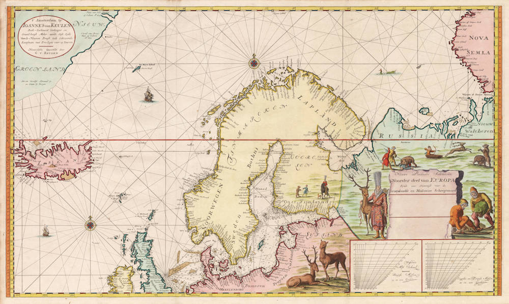
Description
Exceptionally rare and early navigation chart of Scandinavia by the van Keulen publishing house. With highly decorative hunting scenes. A grand showpiece.
The chart is on Mercator's projection with increasing degrees of lattitude. Variable 'sliding' graduation scales ("checkerboards") are given in the lower right, to compensate for the projection distortion at this lattitude, both in Dutch nautical miles (15 in a degree) as well as English/French nautical miles (20 in a degree). The map shows many depth soundings in fathems, especially in the North Sea, the Baltic Sea, around Iceland and along the northern Russian arctic coasts.
Because of its huge size (59.0 x 100.5 cms), the chart was not included in regular van Keulen atlases but sold as a loose navigation chart for the trade with Archangelsk and for the whale hunting.
The chart was occasionally bound in atlases upon specific request of buyers. Koeman IV Keu 45 mentions one with date 1701 in the first part of 'De Nieuwe Groote Lichtende Zee-Fakkel' of 1734 en Koeman IV, p. 379 as nr. 215.
Curiously, the chart without the date, as offered here, is mentioned in the Van Keulen book p. 193 as extra added chart in unknown state to the Zee-Fakkel of 1722, with the name of Gerard van Keulen added in the upper left address cartouche.
We have never before seen examples of this sea chart offered in the market.
Johannes van Keulen (1654-1711)
Gerard van Keulen (son) (1678-c.1727)
Johannes van Keulen II (grandson) (active 1726-1755)
The Dutch produced a remarkable number of enterprising and prolific map and chart makers but not even the Blaeu and Jansson establishments could rival the vigour of the van Keulen family whose business was founded in 1680 and continued under their name until 1823 and in other names until 1885 when it was from wound up and the stock dispersed at auction.
Throughout the history of the family, the widows several of the van Keulens played a major part, after their husbands' deaths, in maintaining the continuity of the business. The firm was founded by Johannes van Keulen who was registered as a bookseller in Amsterdam in 1678. In 1680 he published the first part of his 'Zee Atlas' which, over the years, was expanded to 5 volumes and continued in one form or another until 1734. More ambitious and with a far longer and more complicated life was his book of sea charts, the 'Zee-Fakkel', first published in 1681–82, which was still being printed round the year 1800. A major influence in the development of the firm was the acquisition in 1693 of the stock of a rival map publisher, Hendrik Doncker.
Although the firm was founded by Johannes van Keulen, he was primarily a publisher; it was his son, Gerard, a talented engraver, mathematician, Hydrographer to the East India Company, who became mainspring of the business which not only published charts but also books on every aspect of geograpy, navigation and nautical matters,
(Moreland and Bannister)
It was grandson Johannes van Keulen (II) who in 1753 produced Volume VI of the Zee-Fakkel for the VOC East Indiamen, containing printed charts for the navigation covering the waters from the Cape of Good Hope to Nagasaki . The atlas was not commercially sold and only for use on board of VOC ships, therefore it is also refered to as the 'secret atlas' odf the VOC. The engraving quality and craftmanship surpasses that of all earlier printed sea charts.
Sea charts from the secret atlas are among the rarest and most desirable sea charts for collectors.