Leen Helmink Antique Maps & Atlases
www.helmink.com
Ruscelli
Carta Marina Nuova Tavola
Certificate of Authentication and Description
This is to certify that the item illustrated and described below is a genuine antique
map, print or book that was first produced and published in 1561, today 464 years ago.
July 6, 2025
Cartographer(s)
Ruscelli
First Published
Venice, 1561
This edition
1562, first state
Size
17.6 x 24.3 cms
Technique
Copper engraving
Stock number
18822
Condition
very good
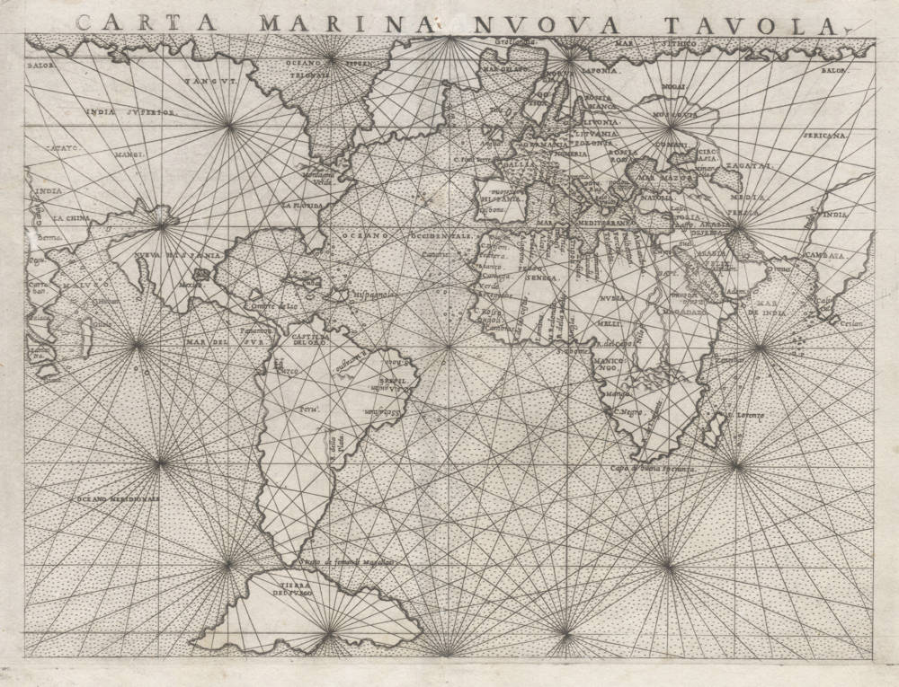
Description
First state, with the copperplate mark running off the top of the map.
"There are two 'modern' world maps in Ruscelli's edition of Ptolemy's Geographia: a double-hemisphere map and a rectangular 'Carta Marina'. Both follow earlier maps - oval and rectangular - which had appeared in Gastaldi's Ptolemaic atlas of 1548."
(Shirley).
"Girolamo Ruscelli (ca. 1504-1566) adapted the maps of Gastaldi's Ptolemy for a new edition, twice the size of the Gastaldi plates. He continued the fine engraving quality of Gastaldi.
According to Thomassy (Les Papes geographes in Nouv. Ann. de Voygaes, 33, 1853, p.155) these particular maps served for the models for the wall-paintings done in the Vatican during the reign of Pope Pius IV.
This sea chart of the world depicts the entirety of the continental northern landmasses as an unbroken ring around the globe. North America and Asia form a single mammoth continent, which in turn connects to northern Europe via Greenland.
The Asia-America connection was a standard concept, and one of which Gastaldi (and in turn Ruscelli) was a particularly strong endorser.
This map's linking of North America and Europe is highly unusual, however, but was a natural consequence of two errors : on the east, Gastaldi depicts Greenland as an elongated east-west outgrowth of Scandinavia, a peculiar pattern used by Waldseemüller earlier in the century on the world map from his atlas of 1513; on the west, he adopts the Verrazanian model for North America which had been sanctioned by Münster in 1540. In combination, these two flawed elements stretched out over the North Atlantic and, quite logically, joined."
(Suárez).
"Known as the 'Mariner's Map', this map is on a scale much to small to be a meaningful or practical sea chart. It is nonetheless crisscrossed with rhumb lines, creating a seaworthy appearance through a spiderweb of nautical images.
The Mariner's world map is particularly interesting. All the continents are linked by means of connections between Asia and North America: North America with Greenland; Greenland with Europe; and Europe with Asia. California is a peninsula. This map predates the discovery of Hudson's Bay and the Great Lakes, and the permanent Northeast American settlements. Nonetheless, the area of New England contains 'Montagna Verde', where today's Green Mountains are!
A slightly larger version of this map appeared in all of the editions of Ruscelli, from 1561 to 1599."
(Manasek on the Gastaldi 1548 prototype of this map).
Girolamo Ruscelli (1504-1566)
Girolamo Ruscelli (1504 Viterbo -1566 Venice), an Italian Alchemist, Physician and cartographer, was editor of a revised and expanded Italian edition of Ptolemy's 'Geographia', published as 'La Geografia di Claudio Tolomeo. The newly engraved maps were based, generally, on those compiled by Giacomo Gastaldi for the Venice miniature atlas edition of 1548.
Ruscelli's atlas was issued several times between 1561 and 1599 by the following publishers
- Venice, Vincenzo Valgrisi, 1561
- Venice, Vincenzo Valgrisi, 1562
- Venice, G. Zileti, 1564
- Venice, G. Zileti, 1574
- Venice, Heirs of Melchior Sessa, 1598-99
The Ruscelli and Gastaldi atlases were the most comprehensive atlases produced between Martin Waldseemüller's 'Geographia' of 1513, and Abraham Ortelius 'Theatrum' of 1570. The significance of the Gastaldi and Ruscelli atlases cannot be overestimated. They defined the known geography of the world for decades. These atlases also reintroduced the use of copper engraving into the service of cartography, which was dominated by woodcut printing after several not very succesful attempts to print from copper in the 15th century. The Gastaldi and Ruscelli atlases proved that maps could be beautifully engraved on copper. As it was a harder material than wood, it was harder to engrave but also gave the ability to render much more detail. The Gastaldi and Ruscelli atlases marked a turning point in the history of cartography, from then on the majority of cartographic works used this medium.
"Ruscelli was editor of a revised and expanded edition of Ptolemy's Geographia which was issued in Venice several times between 1561 and the end of the century.
The newly angraved maps were based, generally, on those compiled by Giacomo Gastaldi for the Venice edition of 1548."
(Moreland & Bannister).