Leen Helmink Antique Maps & Atlases
www.helmink.com
Willem Barentsz
Deliniatio Cartae Trium Navigationum ...
Certificate of Authentication
This is to certify that the item illustrated and described below is a genuine antique
map, print or book that was first produced and published in 1598, today 426 years ago.
April 25, 2024
Dr Leendert Helmink, Ph.D.
Cartographer(s)
Willem Barentsz
First Published
Amsterdam, 1598
This edition
1599 first and only edition
Size
42 x 57 cms
Technique
Copper engraving
Stock number
18819
Condition
excellent
Description
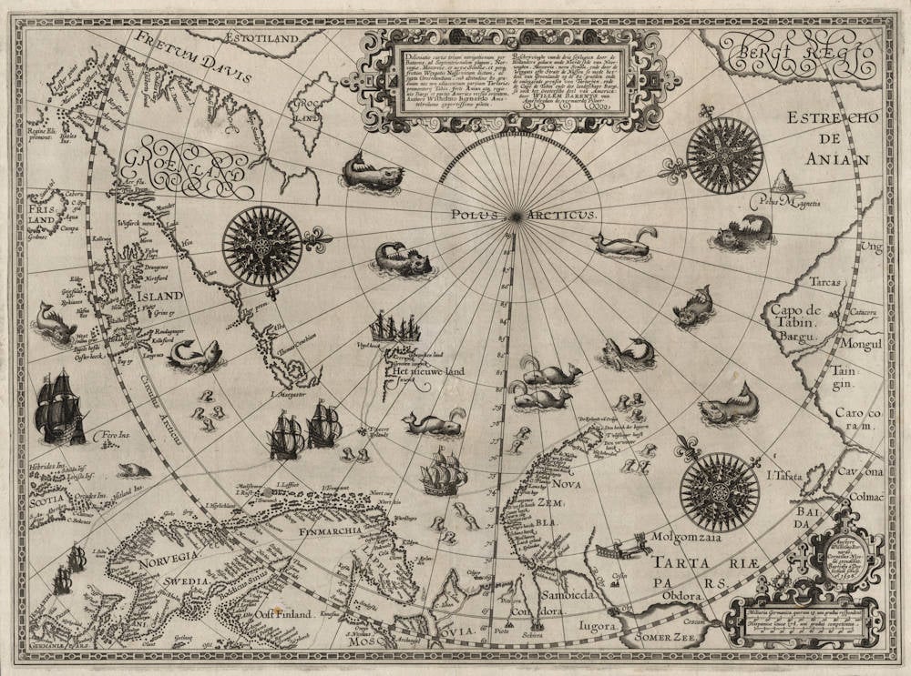
The best map of the Arctic, showing the three attempts of the Dutch to find a route to Asia along the North Pole.
'The most important map of the far northern regions ... [and] the first to show Spitzbergen'
(Ginsberg).
Willem Barentsz made three voyages to the Arctic Ocean. During the first voyage of 1594, he reached the western shores of Novaya Zemlya, and his co-explorer, Jan Huygen van Linschoten, actually managed to enter the Kara Sea at the beginning of August, which was unusually free of ice that year.
The second voyage of 1595 was launched on a much grander scale, with the vision of completing the North-East passage, and included 7 ships loaded with merchandise destined for China. However, this time the approach to was impassable due to ice, and the fleet turned south, landing at Pechora Bay (Pechorskaya Guba).
In 1596 Barentsz undertook a third voyage, the outbound track of which is shown on this map. Barentsz discovered Spitzbergen, and decided to try to enter the Kara Sea by sailing north of Novaya Zemlya. This fateful decision led to the expedition being trapped in the ice and forcing the party to overwinter in a dwelling constructed of salvaged ship's timbers that they named 'Het Behouden Huys' (the safe house), which is shown on the map. In mid-June 1597, the weather permitted the 15 survivors to make their return in open boats along the shores of Novaya Zemlya. Barentsz, already ill, died during the return journey on 20 June. The remains of the hut were discovered in 1871, further relics recovered in 1876, and excavations undertaken in 1993 and 1995.
The detail of the expedition is in the main derived from the journal kept by the ship's carpenter, Gerrit de Veer. Published by Cornelis Claesz in 1598 under the title Waerachtige beschryvinghe van drie seylagien, it was accompanied by 30 copperplate illustrations; this map was published separately.
(Christie's)
The map is drawn in a polar projection with the North Pole as its centre, from which the meridians radiate in straight lines, while the parallels are concentric circles. On one of the meridians the degrees of latitude are indicated between 65° and 90°; the degrees of longitude (without numbers) are presented in segments on three of the parallels.
A scroll-work cartouche below the centre of the upper border contains the map title in Latin and Dutch. In the title, Spitsbergen is referred to as part of Greenland. Gerrit de Veer reported this in his journal on 22 June: 'It is here also to be noted, that although that in this land, which we esteeme to bee Greene-land, lying vnder 80 degrees and more, there groweth leaues and grasse, and that there are such beasts therein as eat grasse, as harts, buckes, and such like beastes as liue thereon’.
In the lower right corner a double cartouche contains two scale bars and references to the author, engraver and publisher of the map. One of the striking features of Barentsz's polar map is the disappearance of imaginary polar islands which had still been present on Plancius's 1594 world map. In their place, the otherwise empty space of the Arctic sea is decorated with sea monsters and three compass roses. To the north of the Strait of Anian (Estrecho de Anian) a high mountain rises from the sea as the magnetic pole (Polus Magnetis). The route taken by the expedition of the 1596 voyage is shown from Holland via Bear Island (Tveere Eylandt) to Spitsbergen (both ships are shown three times), and after the return to Bear Island the route followed by Barentsz's ship to Novaya Zemlya until his winter stay on the northeast coast presents the second part of the expedition.
The most important part of the map contains the original record of the discovery of Spitsbergen in June 1596. This newly discovered land is called Het nieuwe land (The new land). The expedition named some of the principal localities, all of which were names descriptive of the landscape. Curiously, the coastline is represented curving a full right angle instead of continuing almost straight north by west. In this way the coast above the Prins Karls Forland trends east-north-east instead west-north-west. This mistake was remarkably persistent and is found on subsequent maps for a long time. On the polar map various toponyms can be recognized and interpreted. The name Gebroocken land (Broken land) refers to the islands to the northwest of Vest-Spitsbergen. Keerwyck (Bay out of which you must return) at 78°50'N-11°E means the northern part of Forlandsundet. Barentsz had entered Forlandsundet from the north on 26 June 1596, but had been forced to return when he reached Forlandsrevet. Vogelhoeck (Bird hook) at 78°50'N-10°30'E is the northern point of Prins Karls Forland. Grooten inwyck (Large bay) is nowadays Isfjorden at 78°10'N-14°E, the greatest fjord on the west coast of Vest-Spitsbergen. Inwyck (Bay) refers to the Bellsund in 77°40'N-14°E, a fjord system on the west side of Vestspitsbergen. The ships continued their course southwards along the coast until a latitude of 76°50' was reached on 29 June. The ice now drove them out to the sea and Bear Island was sighted once more on 1 July.
Differences of opinion concerning the course to be steered led to separation of the two ships. While Rijp again tried a northern route along Spitsbergen, Barentsz went his own way. After sailing to Novaya Zemlya, he followed its west coast northwards, rounded the most northern cape (Den hoeck der begeerte) but was soon locked in by ice at Ice Haven on 27 August and forced to winter in the extremely severe Arctic conditions. The depiction of Novaya Zemlya synthsizes the results of all Dutch expeditions undertaken in the 1590s.
How accurate was Barentsz's polar map? To answer this question a comparison has been made between the map image offered by Barentsz and a modern one, drawn at the same scale and on the same projection. Contrary to the imperfect delineation of Greenland and Island, the results of Barentsz's observations are surprisingly good. The only notable weakness is the northeastern part of Novaya Zemlya, which can perhaps be explained by bad weather or the inability to determine both compass course (due to inreliability of the magnetic compass) and the latitude. In August we have continuous daylight at this latitude, making it difficult to accurately determine the moment of the sun's meridian passage.
To summarize, Willem Barentsz's 1598 polar map is a landmark map in the history of Dutch exploration of the Arctic. As a bonus, it is also one of the most attractive examples of Dutch map engraving at the end of the sixteenth century.
(Schilder)
Willem Barentsz (c.1550-1597)
Willem Barentszoon was a pilot and Arctic explorer who was convinced by the theorists of the day that it was possible to reach and China and the Far East via a North East passage through the Arctic. On his first voyage in 1594 accompanied by Jan Huyghen van Linschoten he reached Novaya Zemlya but was for back by ice: he failed again the following year. On his third voyage in 1596-97 his ship was trapped in pack ice and, although many of his crew survived in open boats, Barentsz himself died on the return voyage.
He is noted for this 1595 chart book of the Mediterranean, the first of its kind, which was complementary to Waghenaer's charts of the Atlantic coasts, and which is sometimes found bound up with the later editions of Waghenaer.
(Moreland and Bannister)