Leen Helmink Antique Maps & Atlases
www.helmink.com
Braun and Hogenberg
Byzantium Nunc Constantinopolis
Certificate of Authentication and Description
This is to certify that the item illustrated and described below is a genuine antique
map, print or book that was first produced and published in 1572, today 453 years ago.
July 2, 2025
Cartographer(s)
Braun and Hogenberg
First Published
Cologne, 1572
This edition
1572 or later
Size
33.0 x 48.2 cms
Technique
Copper engraving
Stock number
18800
Condition
excellent
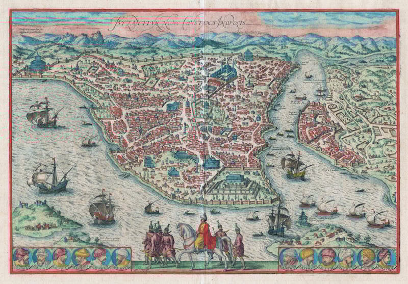
Description
One of the finest and most sought-after views of Istanbul. Viewed from the village of Scutari, the City is shown with all its fortifications, the original Genouse district of Galata on the opposite bank of the Golden Horn to the right. European galleons and Turkish galleys fill the seas of the Bosporus and Golden Horn. The great buildings of 16th century Istanbul during the reign of Suleiman the Magnificent can be clearly seen, including the "Suleymaniye Mosque" and the "Topkapi" palace. The lower center is filled with a parading Turkish horseman and troop of Janissaries.
The original of this map is often incorrectly attributed to Giovanni Andrea Vavassore, called Vadagnino, who created a fine view of Constantinople published in Venice in 1520. Vavassore's view is also said to have influenced the view published in the 1550 and subsequent editions of Sebastian Munster's Cosmographia. Vavassore's view is in turn said to have been based on a 1480 view, now apparently lost, by Venetian artist Giovianni Bellini, who was invited by Mehmet II Fatih, i.e. 'the Conqueror' to Constantinople.
But a closer comparison of the Vavassore, Munster, and Braun & Hogenberg maps or views of Constantinople reveals significant differences. Most notably in the topographic details of the city-scape, especially the Roman remains such as the Hippodrome, today's 'At Meydan', which while not absent in the Vavassore map, is not clearly depicted, whereas it is very clear, detailed and accurate in both the Munster and Braun & Hogenberg maps, as are the locations of churches, palaces and other monuments which are more accurately depicted in the Munster and Braun & Hogenberg maps.
Compared with the Munster map, the Braun and Hogenberg map or view of Constantinople is in particular distinguished and made unique by the portrait of the mounted horseman identified as the Ottoman ruler Suleiman the Magnificent (6 November 1494 - 7 September 1566) who claimed among other titles to be Roman Emperor, a title which even the Holy Roman Emperor Charles V was forced to recognize in 1547.
[ Julian M. Stargardt, LL.B., F.R.G.S.; 1572 Byzantium Nunc Constantinopolis – Georg Braun (1541-1622) and Frans Hogenberg (1535-90)]
Georg Braun (1541-1622)
Frans Hogenberg (c.1536-1588)
In 1572 Frans Hogenberg, who engraved maps for Ortelius, together with another noted engraver of the time, Georg Hoefnagel, compiled and issued in Cologne a City Atlas intended as a companion work to Ortelius' "Theatrum Orbis Terrarum". Entitled "Civitatis Orbis Terrarum" and edited by Georg Braun, the six volumes of this famous work were issued between the years 1572 and 1618 and contained in all more than 500 city plans and views.
The atlas provides a fascinating sixteenth-century picture of the principal cities and towns in Europe, Asia, Africa and even America and records details of public buildings, heraldic devices and rural and domestic scenes, besides many street names.
Towns are usually shown in bird's-eye view, set in picturesque and romantic backgrounds with figures of inhabitants in local dress placed boldly in the foreground.
Although some of the city views had been included in earlier works like Munster's Cosmographia, in most instances they were the first views to appear in print.
The Braun and Hogenberg plates eventually passed to Jan Jansson who reissued the plans in Amsterdam in 1657, having removed the costumed figures which, of course, by this time were no longer of contemporary interest.
(Moreland and Bannister)