Leen Helmink Antique Maps & Atlases
www.helmink.com
Linschoten
Al Cidade de Angra na Ilha de Iesv ...
Certificate of Authentication
This is to certify that the item illustrated and described below is a genuine antique
map, print or book that was first produced and published in 1596, today 428 years ago.
April 19, 2024
Dr Leendert Helmink, Ph.D.
Cartographer(s)
Linschoten
First Published
Amsterdam, 1596
This edition
Size
47.8 x 83.6 cms
Technique
Copper engraving
Stock number
18778
Condition
excellent
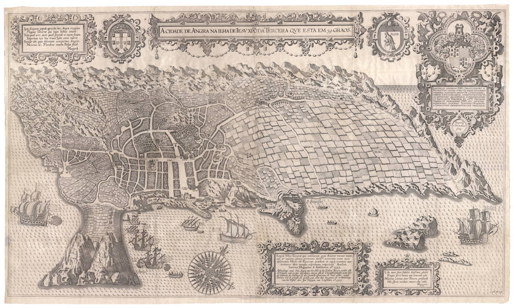
Description
Splendid and very large plan of the city of Angra and the Island of Terceira, one of the Açores Islands from van Linschoten's "Itinerario".
Jan Huygen van Linschoten spent time in Angra on his return trip from Goa to Lisbon. One of the finest and most decorative pieces of cartography engraved by Baptista van Doetichum. Collector's item.
Jan Huygen van Linschoten (1563-1610)
From:
Itinerario
Voyage ofte Schipvaert van
Jan Huygen van Linschoten
naar Oost ofte Portugaels Indien
Amsterdam, 1596
[with several re-issues up until 1638]
Jan Huyghen van Linschoten, a Dutchman born in Delft, was secretary to the Portuguese Archbishop in Goa between 1583 and 1589. These experiences were recorded in the Itinerario, which was first published in Dutch (Amsterdam: 1595-1596), and contains the most comprehensive account of the East and West Indies available at the end of the sixteenth century. As well as including important travel accounts from contemporary Portuguese, Dutch and Spanish sources, it is the first work to include precise sailing instructions for the Indies and also includes an account of America.
The Itinerario provided detailed practical information on how to get to and carry on the trade with America and India. The work was indispensible to sailors on the route to the Indies; it provided a dictionary of exotic commodities, of national trading methods, etc. Linschoten’s work, along with Hakluyt’s, served as a direct stimulus to the building of the vast English and Dutch overseas empires. Legend has it that copies were given to every ship sailing to India to use as a log-book, as is confirmed in many surviving ship's journals.
Monumenta Cartographica Neerlandica VII - Jan Huygen van Linschoten and his Itinerario
For the publication of Van Linschoten's Itinerario, Cornelis Claesz did not settle for the thirty-six illustrations that had been exquisitely engraved by the Van Doetecum family. The publisher felt he should spare no expense to make the 'heerlijck werck' [masterly piece], as he called it, as accessible as possible to the readership interested in geography. Therefore, he had a number of 'nette, perfecte caerten' [beautiful and perfect maps] made for his own account. Besides a world map, five detail maps were included in the Itinerario and the Beschryvinghe. The world map is the map by Petrus Plancius that had already been engraved in 1594 by Joannes van Doetecum Jr. and published by Cornelis Claesz. But in some copies of the 1596-99 editions of the Itinerario, this map was replaced by another world map. The substitution was arranged in co-operation with the Antwerp publisher Joan Baptista Vrients and the replacement map was engraved by the Van Langren brothers.
The five detailed maps of Van Linschoten's Itinerario, all of which were engraved by Arnold Floris and Hendrik Floris van Langren, cover a large proportion of the non-European world known at the time. According to the map titles, these detail maps were composed with the aid of the best Portuguese and Spanish charts and rutters. These maps clearly reveal the influence of the set of maps that Cornelis Claesz had already published previously (1592-94), for which Petrus Plancius was responsible. Plancius's maps were copied for inclusion into Van Linschoten's work. These copies differ only in minor details from the originals.
(Günter Schilder)
Antique Maps - A Collector's Guide
Van Linschoten, born in Haarlem, is heard of in the service of the Portuguese Archbishop of Goa where he spent five years between 1583 and 1588.
On his return to Holland he produced a History of his travels, important for the inclusion of maps from Portuguese sources, at that time rarely available to Dutch – or any other – cartographers. The maps (including a world map by Petrus Plancius) engraved by van Langren, are highly decorative with large cartouches, the arms of Portugal, compass roses, rhumb lines and sea monsters. Some are illustrated with views of prominent places or islands.
(Moreland and Bannister)