Leen Helmink Antique Maps & Atlases
www.helmink.com
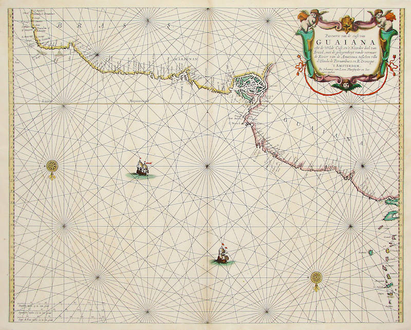
van Loon
Pascaerte van de cust van Guaiana
Certificate of Authentication and Description
This is to certify that the item illustrated and described below is a genuine antique
map, print or book that was first produced and published in 1661, today 364 years ago.
July 1, 2025
Cartographer(s)
van Loon
First Published
Amsterdam, 1661
This edition
1668
Size
42.5 x 54.0 cms
Technique
Copper engraving
Stock number
18762
Condition
excellent
Description
Johannes van Loon's very rare sea chart of the "wild coast" of the mythical Guyanas, with the northeastern coasts of Brazil and including Trinidad and the Leaser Antilles. The chart covers the coasts from Olinda/Pernambuco to Trinidad, including the estuaries of the Amazon and Orinoco rivers. The Lesser Antilles show Tobago, Granada, Barbados, Saint Vincent, Santa Lucia, Martinique, Dominica, Guadeloupe, Antigua and Barbuda.
All charts by Joannes van Loon's Sea Atlas are of exceptional rarity.
Johannes van Loon (1611-1686)
Joannes van Loon was an accomplished mathematician and astronomer. His first cartographic involvements were with Theunis Jacobsz during the 1640s. From 1650 he worked with Joannes Janssonius, engraving amongst other worksthe plates for his Celestial Atlas by Cellarius, 1660.
In 1661 he published his first work with his brother, Gillis; the 'Zee Atlas' contained thirty-five maps. In 1666 the plates were Jan Jansson van Waesberge, with whom he then co-published the atlas. This edition was expanded to forty-seven maps, and by 1676 there were fifty.
(Burden)