Leen Helmink Antique Maps & Atlases
www.helmink.com
Sanson
Florida
Certificate of Authentication and Description
This is to certify that the item illustrated and described below is a genuine antique
map, print or book that was first produced and published in 1657, today 368 years ago.
July 6, 2025
Cartographer(s)
Sanson
First Published
Paris, 1657
This edition
1705
Size
17.5 x 25.0 cms
Technique
Copper engraving
Stock number
18745
Condition
mint
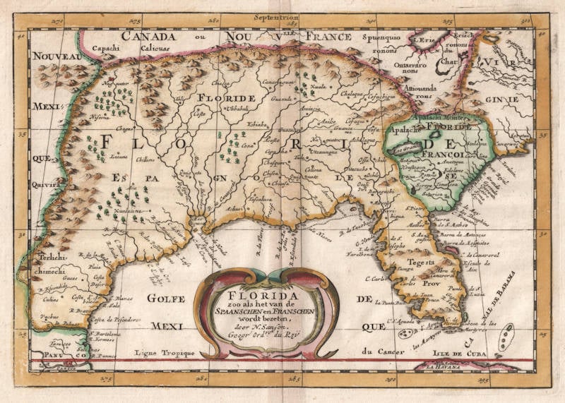
Description
Sanson's highly influential map of the south and the southeast of present-day US. Burden 326, as follows:
LA FLORIDE./ Par N. SANSON d’Abbeville/ Geogr ordre du Roy/ A PARIS/ Chez l’Auteur/ Avecq Privil/ pour 20 Ans./ 1657.
Copperplate engraving, 180 x 255 mm.
From: L’Amerique en plusieurs cartes
Nicolas Sanson here draws upon a portion of his LE NOUVEAU MEXIQUE et LA FLORIDE, of the previous year, for this influential map. It contains the first use of the correct form L. Erie in an atlas, as the folio map was separately published at first. The lake is here placed some 2'/2° too far south, increasing the area claimed by the French. Nearby some of the Virginian rivers are introduced. A strong French assertion is made in FLORIDE FRANCOISE, an area of French inactivity for nearly 100 years. The appearance of Caroline bears no relation to the future English colony of Carolina. It is here a confusion of the French Fort Caroline on the St. Johns River, and Charlefort, built near Port Royal. The inclination of the south-east coast is improved over that of the folio map, being in a more north-easterly direction.
The southern portion of the Florida peninsula regains much of the accepted nomenclature that is absent on the North America. Tegesta provinc. refers to a tribe of Indians living on the south-west coast. The name *Florida' at this time was used to indicate a far larger region. It came to be used solely for the peninsula as the Spanish possession was squeezed south by the expansion of the English colonies. The majority of the map is still dominated by Ortelius-Chaves type nomenclature of 1584. This was an area still virtually unknown to the Europeans, as the confusion over the Mississippi River illustrates. The origin of Mar Pequeno is the Gutiérrez of 1562. There were further editions of the atlas in 1662, c.1667, and before 1690. The author has seen a later issue of the map bearing the date 1702. At this time the maps were still in the possession of the Sanson family. Later dated versions of the North American map exist, and further states of this one could be found.
State 1 1657
With the imprint A PARIS Chez l’Auteur ... 1657
State 2 1662
With the imprint A PARIS Chez P. MARIETTE, rue ... The date is erased and there is no plate number lower right
State 3 c.1667
The plate number 3 is added lower right
State 4 1702
With the imprint A PARIS Chez lAutheur aux Galleries du Louvre Avec Pri. pour 20 ans 1702. In the borders Occident, Orient and Midi have been added
The atlas proved popular and the maps were imitated twice. In Frankfurt, 1679, Johann Zunners published his rare Die Gantze Erd-Kugel ... In 1682, in Utrecht, Joannes Ribbius and Simon de Vries published the Curieuse Aenmerckingen der bysonderste Oost en West Indische. This last series of maps appeared in many works. largely published by François Halma, up to the Henri du Sauzet altases in the 1730s. The differences between them are as follows:
Sanson 1657
In the top border the longitudinal line bisects Septentri on
Zunners 1679
The longitudinal line above bisects differently, Septen- trio
Ribbius 1682
The longitudinal line above does not bisect Septentrion
(Burden)
Nicolas Sanson (1600-1667)
Nicolas Sanson was the foremost French mapmaker of the period.
Sanson was born in Abbeville where as a young man he studied history, particularly of the ancient world, and it is said that he turned to cartography only as a means of illustrating his historical work. For this purpose he prepared a number of beautifully drawn maps, one of which, after his move to Paris, came to the attention of Louis XIII. In due course the King appointed him ‘Géographe Ordinaire du Roi', one of his duties being to tutor the King in geography.
In the preparation of his major atlas, Cartes Générales de Toutes les Parties du Monde, Sanson employed a number of engravers, one of whom, M. Tavernier, engraved important maps showing the Post Roads and River and Waterway system of France (1632–34) and a map of the British Isles (1640). In all, Sanson produced about 300 maps of which two of North America were particularly influential: Amerique Septentrionale (1650) and Le Canada ou Nouvelle France (1656), the first map to show all the Great Lakes. After Sanson's death the business was carried on by his two surviving sons and grandson, in partnership with A. H. Jaillot.
It is generally accepted that the great age of French cartography originated with the work of Nicolas Sanson but credit must go also to A. H. Jaillot and Pierre Duval for re-engraving his maps, many still unprinted at his death, and re-publishing them in face of strong competition from the Dutch, who continued to dominate the market until the end of the century.