Leen Helmink Antique Maps & Atlases
www.helmink.com
Gastaldi / Ptolemy
Tabula Europae III
Certificate of Authentication and Description
This is to certify that the item illustrated and described below is a genuine antique
map, print or book that was first produced and published in 1548, today 477 years ago.
July 2, 2025
Cartographer(s)
Gastaldi / Ptolemy
First Published
Venice, 1548
This edition
1548 first and only edition
Size
13.0 x 17.0 cms
Technique
Copper engraving
Stock number
18713
Condition
excellent
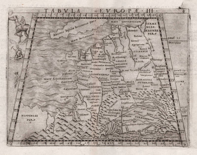
Description
Ptolemy's third map of Europe by Giacomo Gastaldi, covering France. Gallic warriors are depicted in the left border.
Giacomo (Jacopo) Gastaldi (c.1500-1566)
"In Venice in 1548, Giacomo Gastaldi engraved a fine series of maps for what is seen as the first 'pocket' or miniature atlas."
(Potter p38)
"Praised as 'that most excellent of cartographers', Gastaldi was a native of Piedmont and worked in early life as an engineer in the service of the Venetian Republic before turning in the early 1540s to cartography as a profession. Eventually he was appointed Cosmographer to the Republic.
From 1544 onwards he produced a large number of maps beautifully engraved on copper, using a style which was widely copied by his contemporaries, indeed, his technique marked the final transition away from woodblock printing which had been predominant for so long.
Apart from compiling maps of the world and the continents he was responsible for the maps in an edition of Ptolemy issued in 1548 and in a noted collection of voyages and travels called 'Delle Navigazioni e Viaggi' by Giovanni Battista Ramusio (1485-1557). Many of his maps were included in the Lafreri collections of maps in the 1560–80 period.
Gastaldi is credited with popularizing the idea that a route round the north of the American continent led to a passage which he called the Strait of Anian, named after Marco Polo's Kingdom of Anian. The name appeared on many maps well into the seventeenth century."
(Moreland & Bannister p66)
"Jacopo Gastaldi, 'most excellent' of cosmographers, produced a pocket version of Ptolemy in 1548. 'La Geografia di Claudio Ptolemeo' (with 'criticisms and additions' by Sebastian Münster) contained 26 maps from Ptolemy [..], and 34 new maps (some of the New World)."
(Tooley & Bricker)
"Jacopo Gastaldi, born in Piedmont in about 1500, and by the 1540s cosmographer to the Venetian Republic. At least a hundred maps are attributable to Gastaldi, including his 1548 'Geographia' (published by Nicolo Bascarini). It was a popular edition in Italian prose, and expressly designed in quarto, with maps only 5 by 6.75 inches, so that it could be carried 'nella manica' - in the sleeve. (Quarto is the page size that results when a full-sized printed sheet is folded twice instead of a single time that gives a 'folio' page.).
Gastaldi's contemporaries usually described him as the 'most excellent Piedmontese cosmographer'. As a dedicated professional he worked for a number of publishers, accepting occasional private commissions, as when Venice's all-powerful Council of Ten commissioned him to make fresco maps of Asia and Africa for the walls of a room in the Doge's Palace"
(Tooley & Bricker)
"A small but very elegant Italian [Ptolemy] edition with plates, handsomely engraved in copper by the famous cosmographer Gastaldi. [...]. A whole series of plates of the New World is here met with, for the first time, and some of them are of no slight interest to the history of cartography."
(Nordenskjöld 28)
"Sixty maps are engraved in copper in Mattiolo-Gastaldi's Ptolemy of 1548. [...]. On the title-page is written: 'Con alcuni comenti et aggiunti fattevi da Sebastiano Munstero Alamanno, but this evidently refers to the text, not to the maps, which, from a geographical point of view as well as in their technical execution, are immensely superior to those of the learned geographer and Hebrew professor at Basel.
The work is dedicated by Iacobo Gastaldi to Leone Strozzi, 'dignissimo Signore di Capua', whereupon follows an 'A li lettori', where the publisher, Giovanbattista Pedrezano, is highly complimented, for not having spared any expense in getting the maps as finely and well executed as possible, and for having reduced their size as to allow of anybody, without difficulty, carrying the work 'nella manica'. We thus have here the first atlas expressly said to be published in a pocket form."
(Nordenskjöld 40)
"This edition of Ptolemy's 'Geography' was the most comprehensive atlas produced between Martin Waldseemüller's 'Geographia' of 1513, and the Abraham Ortelius 'Theatrum' of 1570. It was the first to contain regional maps of the American continent.
Giacomo Gastaldi had the maps beautifully engraved on copper. This marks a turning point, from now on the majority of cartographic works used this medium. As it was a harder material than wood it gave the engraver the ability to render more detail. Born in Villafranca, Piedmont, Gastaldi became Cosmographer to the Venetian Republic, then a powerhouse of commerce and trade. He sought the most up to date geographical information available, and became one of the greatest cartographers of the sixteenth century."
(Burden 16)
Claudius Ptolemy (c.100 - c.170)
Ptolemy, Latin in full Claudius Ptolemaeus was an Egyptian astronomer, mathematician, and geographer of Greek descent who flourished in Alexandria during the 2nd century AD. In several fields his writings represent the culminating achievement of Greco-Roman science, particularly his geocentric (Earth-centred) model of the universe now known as the Ptolemaic system.
Virtually nothing is known about Ptolemy’s life except what can be inferred from his writings. His first major astronomical work, the Almagest, was completed about 150 ce and contains reports of astronomical observations that Ptolemy had made over the preceding quarter of a century. The size and content of his subsequent literary production suggests that he lived until about 170 AD.
Astronomer
The book that is now known as the Almagest (from a hybrid of Arabic and Greek, “the greatest”) was called by Ptolemy Hē mathēmatikē syntaxis (“The Mathematical Collection”) because he believed that its subject, the motions of the heavenly bodies, could be explained in mathematical terms.
Mathematician
Ptolemy has a prominent place in the history of mathematics primarily because of the mathematical methods he applied to astronomical problems. His contributions to trigonometry are especially important. For instance, Ptolemy’s table of the lengths of chords in a circle is the earliest surviving table of a trigonometric function. He also applied fundamental theorems in spherical trigonometry (apparently discovered half a century earlier by Menelaus of Alexandria) to the solution of many basic astronomical problems.
Among Ptolemy’s earliest treatises, the Harmonics investigated musical theory while steering a middle course between an extreme empiricism and the mystical arithmetical speculations associated with Pythagoreanism. Ptolemy’s discussion of the roles of reason and the senses in acquiring scientific knowledge have bearing beyond music theory.
Geographer
Ptolemy’s fame as a geographer is hardly less than his fame as an astronomer. Geōgraphikē hyphēgēsis (Guide to Geography) provided all the information and techniques required to draw maps of the portion of the world known by Ptolemy’s contemporaries. By his own admission, Ptolemy did not attempt to collect and sift all the geographical data on which his maps were based. Instead, he based them on the maps and writings of Marinus of Tyre (c. 100 ce), only selectively introducing more current information, chiefly concerning the Asian and African coasts of the Indian Ocean. Nothing would be known about Marinus if Ptolemy had not preserved the substance of his cartographical work.
Ptolemy’s most important geographical innovation was to record longitudes and latitudes in degrees for roughly 8,000 locations on his world map, making it possible to make an exact duplicate of his map. Hence, we possess a clear and detailed image of the inhabited world as it was known to a resident of the Roman Empire at its height—a world that extended from the Shetland Islands in the north to the sources of the Nile in the south, from the Canary Islands in the west to China and Southeast Asia in the east. Ptolemy’s map is seriously distorted in size and orientation compared with modern maps, a reflection of the incomplete and inaccurate descriptions of road systems and trade routes at his disposal.
Ptolemy also devised two ways of drawing a grid of lines on a flat map to represent the circles of latitude and longitude on the globe. His grid gives a visual impression of Earth’s spherical surface and also, to a limited extent, preserves the proportionality of distances. The more sophisticated of these map projections, using circular arcs to represent both parallels and meridians, anticipated later area-preserving projections. Ptolemy’s geographical work was almost unknown in Europe until about 1300, when Byzantine scholars began producing many manuscript copies, several of them illustrated with expert reconstructions of Ptolemy’s maps. The Italian Jacopo d’Angelo translated the work into Latin in 1406. The numerous Latin manuscripts and early print editions of Ptolemy’s Guide to Geography, most of them accompanied by maps, attest to the profound impression this work made upon its rediscovery by Renaissance humanists.
(Britannica)