Leen Helmink Antique Maps & Atlases
www.helmink.com
Thévenot
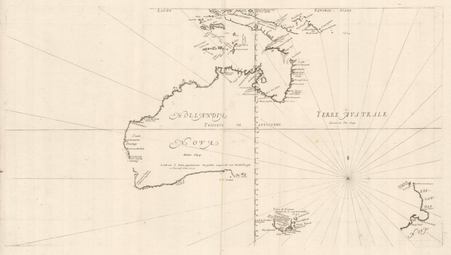
HOLLANDIA NOVA detecta 1644 TERRE AUSTRALE découverte l'an 1644.
Certificate of Authentication and Description
This is to certify that the item illustrated and described below is a genuine antique
map, print or book that was first produced and published in 1663, today 362 years ago.
July 1, 2025
Cartographer(s)
Thévenot
First Published
Paris, 1663
This edition
Paris, 1672
Size
38 x 53.5 cms
Technique
Copper plate engraving
Stock number
18687
Condition
mint
Description
Summary
The first printed map dedicated to Australian. A seminal map for collections of the fifth continent.
Condition
Pristine condition. State 3 of 4, with the rhumb lines added. All states are important and rare. Thick and clean paper. No restorations or imperfections. Folded as issued. Strong and dark imprint of the copperplate. Unusually wide margins all around. A flawless copy of an exceptionally rare landmark map of Australia, by one of the most important cartographers of its day.
Provenance: Ex Collection Geoffrey Allan Edwards (1947-2019)
The drama of the Batavia
In the travel anthology Relations de divers voyages curieux, published in 1663 by the French scientist Thévenot, this is the first French map on which Tasman's discoveries were taken into account.
It is of interest that the 1663 edition of the travel anthology just brings the general map of the Dutch discoveries including those by Tasman, while the text refers only to the loss of the Batavia. In the edition of 1696 extracts from Tasman's journal are printed, as well as the revised map with Tasman's track.
(Schilder)
THE FIRST PRINTED MAP OF THE AUSTRALIAN CONTINENT
Thévenot's great collection of voyages was published over three decades from 1663 - 1696. A scholar of prodigious energy, Melchisedech Thévenot assembled his remarkable collection of accounts of the newly explored and newly discovered regions of the world from original manuscript and printed texts, conversations with travellers, and other diverse sources, including accounts of travels in China, Japan, Thailand, Tartary, Mongolia, the Philippines, India, Egypt, Ethiopia, Arabia, Persia, Russia, North, Central and South America, the Pacific, New Guinea, and New Holland. His work grew, with various sections published haphazardly and then cumulated in 1663, 1666, 1672, 1683, and 1696.
The Australian portion of the work comprises an abridged translation of Pelsaert's account of the wreck and mutiny of the Batavia, the first appearance of the account in another language. Associated with the Pelsaert account and of major importance is Thévenot's printing of the Tasman map, "Hollandia Nova Terre Australe”, effectively the first appearance of Tasman's discoveries in print. This was the first printed map devoted to the Australian continent. Thévenot states that his map, embodying new detail from Tasman's voyages, was prepared on the basis of the marble and mosaic world map on the floor of the Town Hall in Amsterdam, although other sources certainly contributed to its high degree of precision. Thévenot's map is highly regarded for its severe accuracy, eschewing any of the hypothetical and fanciful embellishments and conjectures of his predecessors and contemporaries. His map was a seminal influence for almost a century. As L.C. Wroth observed: "it was probably the Thévenot map rather than its prototypes which brought to the world at large the first sound idea of the shape and location of the new fifth continent disclosed by the Dutch explorations...” (quoted in Quaritch 1085/50).
The Thévenot map was reworked and reprinted at least four times and these various states made their appearance with each new issue of the growing work. The present copy contains the very rare first issue in its first state: with the latitudes incorrectly numbered, without the Tropic of Capricorn, without rhumb lines, and without Tasman's track. The Davidson collection includes all four states (see following lots).
(Australian Book Auctions, the Davidson Collection Sale, 2005)
Melchisedech Thévenot (1620-1692)
A traveller and author of books on the early voyages of discovery, Thévenot produced some striking charts, perhaps not always his own work but no less interesting because of that. In particular, his map of Australia is the first by a Frenchman, showing the continent with the latest information on Tasman's voyages.
(Moreland and Bannister)
[Tasman] Thévenot, Melchisedech. Relations de Divers Voyages Cvrievx, qui n'ont point esté pvbliées; ov qvi et esté tradvites d'Haclvyt, de Purchas, & d'autres Voyageurs Anglois, Hollandais, Portugais, Allemands, Espagnols; et de quelques Persans, Arabes, et avtres Auteurs Orientaux. Enrichies de Figures de Plantes non décrites, d'Animaux inconnus à l'Europe, & de Cartes Geographiques de Pays dont on n'a point encore donné de Cartes. Première Partie. Paris, Jacques Langlois and Gaspard Meturas, Simon Piget, Emanuel Langlois, Thomas Jolly, and Louys Billaine, 1663.
Thévenot's great collection of voyages was published over three decades from 1663 - 1696. A scholar of prodigious energy, Melchisedech Thévenot assembled his remarkable collection of accounts of the newly explored and newly discovered regions of the world from original manuscript and printed texts, conversations with travellers, and other diverse sources, including accounts of travels in China, Japan, Thailand, Tartary, Mongolia, the Philippines, India, Egypt, Ethiopia, Arabia, Persia, Russia, North, Central and South America, the Pacific, New Guinea, and New Holland. His work grew, with various sections published haphazardly and then cumulated in 1663, 1666, 1672, 1683, and 1696.
Thévenot's Relations is a bibliographically complex work. Effectively there was only one edition, issued in parts over three decades. The first part (the present lot) was published in 1663. Between 1664 and 1683 Thévenot issued further parts and cumulative volumes of the parts already issued. In each case, these subsequent issues included some reprinted sheets, plates, and maps. In its final, posthumous, form the work was issued in 1696 in two volumes. The haphazard nature of publication - with the variously paged parts issued and re-issued, printed and reprinted - means that copies are never entirely identical and often 'incomplete'. Bibliographers have generally avoided detailed descriptions; as Brunet remarks, it is a book of which wil est difficile de trouver des exemplaires complets parce que chaque partie est composé de pièces séparées"; while Sabin declines to collate this or the 1696 edition since "no simple standard arrangement or collation can be given". Brunet notes several variations from copy to copy and the present example accords with his 'ideal description. Of the specific variations he records, the following have been noted in this copy: pp. 7-8 in Terri's voyage are replaced with the map of the Indies as noted "quelquefois” by Brunet; pp. 55-6 in the “Voyage de Bontekoë" are correctly numbered; and, finally, this copy includes at the end the “Routier des Indes Orientales" and the "Privilege” that are not always present.
(Australian Book Auctions, the Davidson Collection Sale, 2005)