Leen Helmink Antique Maps & Atlases
www.helmink.com
Benedictus Arias Montanus
Benedict Arias Montanus Sacrae Geographiae Tabulam ex Antiquissimorum Cultor.
Certificate of Authentication and Description
This is to certify that the item illustrated and described below is a genuine antique
map, print or book that was first produced and published in 1572, today 453 years ago.
July 6, 2025
Cartographer(s)
Benedictus Arias Montanus
First Published
Antwerp, 1572
This edition
1660
Size
31.3 x 52.8 cms
Technique
Copperplate engraving
Stock number
18662
Condition
excellent
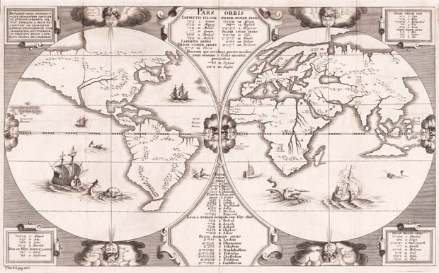
Description
One of the earliest maps to suggest an Australian landmass, almost half a century before it was discovered. The map shows North America as part of Asia, a favourite theory of Charles V of Spain, whose Empire encompassed most of Europe and the Americas.
Embellished with lots of sea monsters and carracks after Pieter Bruegel the Elder.
The map was engraved in 1571, as stated in the title. It was first published in 1572.
BENEDICT. ARIAS MONTANVS SACRAE GEOGRAPHIAE TABVLAM EX antiquissimorvm cvltor. familiis a Mose recensitis ad sacrorvm libror. explicandor. Commoditatem Antvverpiae in Philippi regis catholici gratiam describebat. 1571.
Copper engraving
525 x 310 mm
This rare map has a special place in the early cartography of Australia. It is a world map from the so-called Polyglot Bible (1569–73) by Christopher Plantin. On the eastern hemisphere the triangular corner of an unknown country is shown emerging from the waves at a point where on modern maps, northern Australia is situated. This indicates the northern part of an unexplored country, a suggestion of incomplete discovery which in this form does not appear on any earlier map. In this coastline, rising mysteriously from the sea, some scholars believe there is an indication of the discovery of Australia in the sixteenth century. The engraving is very rare as the greater part of this edition of the bible was lost at sea.
Source: M.M. Rotterdam, W.A.E. 852.
Reproduction: Remarkable Maps, II/1.
(Schilder Map 20)
Benito Arias (Montano)
Antwerp, 1571 [1572].
315 x 530 mm.
Benedict Arias Montanus Sacrae Geographiae Tabulam Ex Antiquissimorum ... 1571.
From: 'Biblia Sacra, Hebraice, Chaldaice, Graece & Latine ...'
Benito Arias, called Montano from his birthplace, edited this eight-volume Polyglot Bible with text in Hebrew, Greek, Latin and Syriac. It was prepared under the patronage of Philip II of Spain and published between 1569 and 1572, with the printing being carried out by Plantin of Antwerp.
Volume 8, issued in 1572, contains a well-engraved world map. Inserted principally for theological reference it shows, amongst other detail, how the tribes of Israel were disseminated. The title is in a panel in the top left-hand corner: other panels contain text in Hebrew and Latin. There is an unusual island shown in the position of Australia which has given rise to speculation, although in common with other spurious land masses off the east coast of America it probably represents no more than the engraver's licence.
The map from the first edition, of which the greater number of impressions were lost at sea on route for Spain, has printed on the reverse Orbis Tabula. Ben. Aria Montano. Auctore. In state 2 the word gentes has been added below the word Iektan in the lower left panel. Mr Tully of Australia has advised me of a second plate with minor but significant differences in treatment. The date (1571) is now placed centrally to conclude the title, Iektan is spelled Ioktan, and the cherub at the head of the western hemisphere is unambiguously gazing to the left compared to the frontwards look of the same cherub in plate 1.
BL 6.h.4-11 (Bible); MMR WAER 852.
T.H. Darlow and H.F. Moule, Historical Catalogue of the Printed Editions of Holy Scripture, London, 1903, (reprinted New York, 1963), vol II-I, pp. 9-12; Muller II-1; Schilder, Map 20; Wagner 86.
(Shirley Map 125 and Plate 107 [but showing the second plate])
MONTANUS, Arias 1571 (after 1571)
PARS ORBIS (top panel)
BENEDICT ARIAS MONTANUS
SACRAE GEOGRAPHIAE TABULAM EX ANTIQUISSIMORUM.
49.8 x 33.8 cms
The rare first state of Montanus' 1571 world map in twin hemispheres showing the re-population of the earth by Noah's sons.
Between 1569 and 1572, Christopher Plantin published his famous eight volume Polyglot Bible (being written in Latin, Greek, Syriac and Hebrew). Published under the Patronage of Philip II of Spain, the final volume contains a world map executed by Arias Montanus. As the majority of the editions that contained the world map were lost at sea en route to Spain, the map is of some rarity.
Montanus' map shows the distribution throughout the world of Noah's sons and their offspring as they re-populated the earth after the Great Flood. A numerical and alphabetical reference system identifies where each of his progenies settled.
The map is simply but elegantly drawn and features north, south, east and west cherubim headwinds on each globe. Of particular interest is the triangular shaped island appearing south of the East Indies and in roughly the position of Australia. It has been suggested (not infrequently), that the depiction of this island represents Portuguese knowledge of Australia, prior to the 1606 Dutch discovery by Jansz. Shirley states "it probably represents no more than the engraver's licence". In all likelihood however it represents the northern most promontory of 'Terra Australis Incognita', a residue of the more traditional representation of the southern continent as seen in maps such as Ortelius' 1570 world map.
This is also evidenced by a similar landmass seen at the bottom of South America, representing the tip of another promontory of Terra Australis.
It would appear that Montanus has attempted to present a variant concept of Terra Australis Incognita. Although Gastaldi shows a large single island off the tip of South America on his 1548 world map, Montanus for the first time shows just such a representation off Southeast Asia.
A few variations and editions of Montanus' map are known to exist. Plate 1, state 1 (this map) has ‘lektan' at the end of the third last line in the lower left text panel. In state 2 'gentes' is squeezed in below ‘lektan'. Plate 2 has significant changes. The wind cherubs look in different directions, there is less engraved sea under the Antarctic circle and the date 1571 now has its own line in the text panel at top left (see Shirley's illustration). 'Gentes' is now on the same line as 'loktan' ('lektan' in the first plate) in the text panel at lower left. The landmass below South America is now shown as an island.
Shirley 125, p.107 (second plate illustrated); Schilder map 20, illus. p.203; Clancy Terra Australis map 5.7, illust. p.66.
(Dewez/Gowrie Galleries)
Benedictus Arias Montanus (1527-1598)
Benito Arias Montano was a Spanish priest and Orientalist; born in 1527 at Freseenal, Estremadura; died 1598 at Seville. Philip II entrusted him with the editing of the Polyglot Bible which was printed in Antwerp (1568-1572) under the title "Biblia Sacra, Hebraice, Chaldaice, Græce, et Latine, Philippi II., Regis Catholici Pietate et Studio ad Sacrosanctæ Ecclesiæ Usum Chph. Plantinus Excudebat."
Arias was accused of Judaizing, on account of his insertion in the Polyglot of certain Aramaic paraphrases tending to confirm the Jews in their claims; but he was acquitted of the charge through a favorable report on the matter by the inquisitor, P. Mariana (1580). He translated Benjamin of Tudela's "Masa'ot" into Latin (1575, 1636, 1764), and was the author of "Antiquitatum Judaicarum" (published, with engravings, in Leyden, 1593), and many other works.
(Gottheil and Porter)
Arias Montanus (Benedictus)
A Spanish priest and Orientalist, born in Estremadura (in a mountainous district, whence the name Montanus) in 1527, of noble but poor parents. He distinguished himself early by his acquaintance with the Oriental languages, and was ordained priest in the order of St. James, of which he had become a clerk.
The bishop of Segovia took him with him to the Council of Trent, after which Arias retired to the monastery of Our Lady "de los Angelos," in the mountains of Andalusia, whence, however, he was recalled by King Philip II, to labor at the new Polyglot Bible, which he was causing to be made after that of Alcala, at the suggestion of the celebrated printer Plantin. This Bible was printed at Antwerp, in 1571, under the title Biblia Sacra, Hebraice, Chaldaice, Greece, et Latine, Philippi II, Regis Catholici Pietate et Studio ad SacrosancteB Ecclesice Usum Ch h. Plantinus excudebat (8 vols. fol.).
The "Polyglot" in every respect justified the high expectation which had been formed of it; but in a voyage from the Netherlands to Spain nearly all the copies were lost. The king remunerated Arias's labors by giving him a yearly pension of 2000 ducats, besides other honorary rewards and lucrative offices. Arias was an upright, sincerely orthodox Romanist, but he was a declared enemy of the Jesuits, and that ambitious order omitted no opportunity to take revenge on so dangerous a foe — the more powerful because his orthodoxy had never been questioned, and was supported by uncommon erudition. He was accused of Judaism because he had inserted in the Polyglot certain Chaldee paraphrases, which tended to confirm the Jews in their errors. He made many voyages to Rome to justify himself, and in 1580 was honorably dismissed, and died at Seville in 1598, prior of the convent of St. Jago.
Arias's numerous and extensive literary works chiefly belong to theological, but partly also to classical literature, but his Polyglot certainly holds — the principal place; it is generally called the "Antwerp Polyglot," or, from the patronage bestowed on it by Philip II, "Biblia Regia," and sometimes also, after the printer, "Biblia Plantiniana."
(McClintock)