Leen Helmink Antique Maps & Atlases
www.helmink.com
Tallis
Western Australia, Swan River
Certificate of Authentication and Description
This is to certify that the item illustrated and described below is a genuine antique
map, print or book that was first produced and published in 1851, today 174 years ago.
July 6, 2025
Cartographer(s)
Tallis
First Published
London/NY, 1851
This edition
1851
Size
25.5 x 34.0 cms
Technique
Steel engraving
Stock number
18647
Condition
excellent
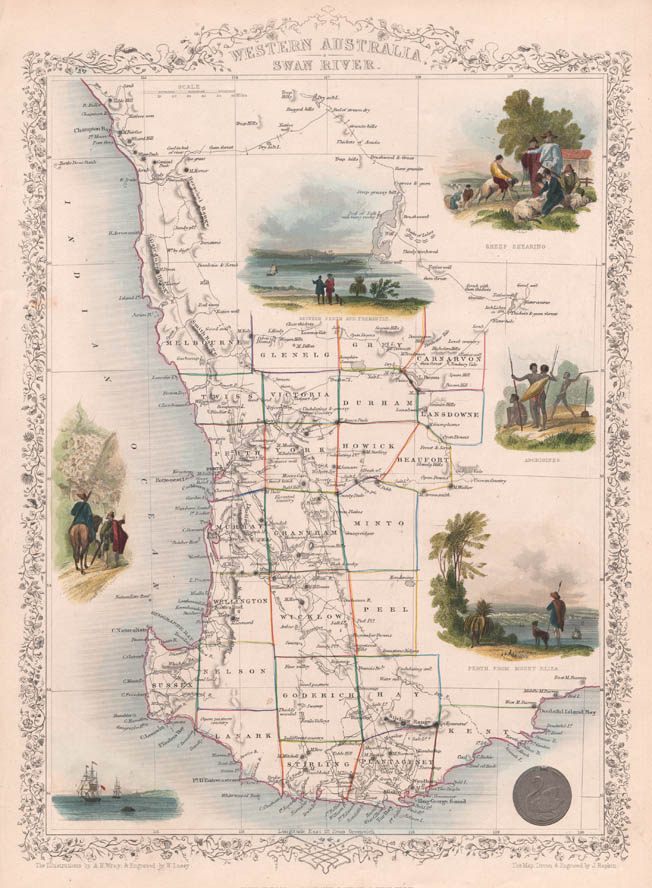
Description
Vignette views of
"Sheep shearing"
"Aborigines"
"Perth from Mount Elixa"
"Between Perth and Fremantle"
and of ships anchoring off Swann River estuary.
"John Tallis' Illustrated Atlas reflects a movement away from the sombre scientific style that so typified early nineteenth-century mapmaking. Published to commemorate the Great Exhibition of 1851, Tallis' beautiful maps, engraved on steel by John Rapkin, reflects the glories of Britain's world empire and provide a pastiche of images of far-flung corners of the world available for the first time to the Victorian armchair traveller."
(Barron).
"All the maps and plans have ornamental borders and most have vignette scenes; they are invariably described as 'the last decorative series of maps ...'. "
"Another series, which is especially popular for its decorative borders and vignette scenes, is that by John Tallis published in London and New York."
(Potter).
"Frequently referred to as 'the decorative series of world maps', these are attractively designed, informative pieces which combine the best elements of scientific cartography and decorative art as the great early mapmakers did. The decorative borders and attractive vignette scenes contrasted vividly with the austere approach of many other comparable atlas publishers of the time, whose use of decoration was negligible although the cartographic quality of their output was undoubted."
(Potter/Martin)
"... the last pictorial maps in the old tradition."
(Tooley & Bricker).