Leen Helmink Antique Maps & Atlases
www.helmink.com
de Jode
Moscoviae Maximi Amplissimi Que Ducatus chorographica descriptio Authore ...
Certificate of Authentication and Description
This is to certify that the item illustrated and described below is a genuine antique
map, print or book that was first produced and published in 1578, today 447 years ago.
July 1, 2025
Cartographer(s)
de Jode
First Published
Antwerp, 1578
This edition
1593
Size
32.5 x 50.0 cms
Technique
Copper engraving
Stock number
18571
Condition
excellent
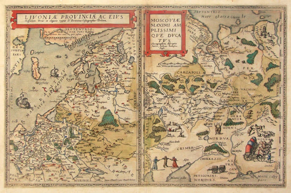
Description
Very rare map of Russia, Ukraine, Belarus and Livonia, two maps on one sheet, from Cornelis de Jode's 1593 'Speculum Orbis Terrarum'. The map is engraved by his father Gerard de Jode and was first issued in 1578. The maps are decorated with local wildlife, tartars, and worship. This 1593 edition is the same state as the 1578, and can be distinguished only by the page number and the bookbinders signature on the back of the map.
The copperplate has been engraved by Johannes and Lucas van Doetecum, the finest engravers of the time. It was very difficult to obtain accurate geographical information of these regions, because the area was not accessible for Europeans. The map is one of the best and most detailed early maps that is obtainable for collectors.
The map is modeled after a manuscript wall map by Englishman Anthony Jenkins who was the main trader of the Muscovy Company, which had a monopoly on trade between England and Russia. The original map by Anthony Jenkinson was only rediscovered in the 1980s in the British Library.
Gerard de Jode (c.1509-1591)
Cornelis de Jode (son) (1568-1600)
Gerard de Jode originally issued his atlas in 1578 to compete with Ortelius' atlas with little success. In 1593, two years after his death, Gerard's son Cornelius re-issued the atlas. The success of the atlas was very limited due to heavy competition with Ortelius, who also seems to have bought many copies of de Jode's atlas to take them off the market. Because of this, both editions of the de Jode atlas are exceptionally rare.
"Gerard de Jode, born in Nijmegen, was a cartographer, engraver, printer and publisher in Antwerp, issueing maps from 1555 more or less in the same period as Ortelius. He was never able to offer very serious competition to his more businesslike rival although, ironically, he published Ortelius's famous 8-sheet World Map in 1564. His major atlas, now extremely rare, could not be published until 1578, eight years after the 'Theatrum', Ortelius having obtained a monopoly for that period.
The enlarged re-issue by his son in 1593 is more frequently found. On the death of Cornelis, the copper plates passed to J.B. Vrients (who bought the Ortelius plates about the same time) and apparently no further issue of the atlas was published."
(Moreland & Bannister).
"After the death of Cornelis in 1600, the copper-plates came into the hands of Jan Baptiste Vrients, then the publisher of Ortelius' Theatrum. Apparantly Vrients must have bought them to prevent any further publication of the Speculum."
(Koeman)