Leen Helmink Antique Maps & Atlases
www.helmink.com
de Laet
Americae sive Indiae Orientalis Tabula Generalis
Certificate of Authentication and Description
This is to certify that the item illustrated and described below is a genuine antique
map, print or book that was first produced and published in 1630, today 395 years ago.
July 1, 2025
Cartographer(s)
de Laet
First Published
Leiden, 1630
This edition
1630 first edition
Size
27.8 x 35.5 cms
Technique
Copper engraving
Stock number
18564
Condition
excellent
Description
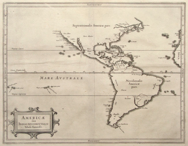
Seminal early map of the Americas and the Pacific, by Hessel Gerritsz, arguably the best cartograper of the day, and offical map maker of both the East and West India Company.
It is the elegant overview map of what is only the second atlas devoted to the Americas (after the Wytfliet of 1597).
The map shows the latest discoveries of the Dutch in North America and in the Pacific.
Condition
First issue. Excellent collector's condition.
The Mapping of North America
Considerable effort went into making the text and maps of this work the most accurate available at the time. It is arguably the fines description of the Americas published in the seventeenth century. The exhaustive research involved de Laet reading all of the published and manuscript material that he could find.
For the cartographic work he had much to call on, being a director of the recently formed Dutch West India Company in charge of all Dutch interests in America and Africa. He therefore had access to the latest geographic knowledge.
He also drew upon the fine talents of Hessel Gerritsz, the official cartographer to the Dutch East India Company since 1617. This was a post he attained before Willem Blaeu under whom he was apprenticed, and who was his senior by ten years.
The maps were some of the first to depart from the heavier style of the Mercator and Ortelius period. This more open style of engraving was one that both Blaeu and Janssonius would develop in their atlases. The first edition of the book in 1625 contained ten maps which concentrated on South America. Since then the Dutch had taken considerable interest in New Amsterdam (New York), and the work was expanded by some 100 pages and four newly engraved maps.
The first of these additional maps is was a general one of the continent. Its most interesting feature is that although we know de Laet had seen maps of California as an island, he relies on the more trustworthy accounts, such as Herrera, in depicting a peninsular form. The map has the best west coast delineation to date. He also does not get drawn into the debate about the North West passage, preferring to cut his map short of these latitudes. It appeared in the subsequent editions in Latin, 1633, and French, 1640. In all of these there is no text on the reverse.
(Burden map 229).
In 1630 Johannes de Laet's volume L 'Histoire du Nouveau Monde ou Description des Indes Occidentalis included 14 maps engraved by Hessel Gerritsz. These fine maps are restrained in style but were the best of the period and influenced the subsequent maps of Blaeu and Jansson, particularly in the regions of the eastern seaboard of North America.
(Potter).