Leen Helmink Antique Maps & Atlases
www.helmink.com
Sanson
Les Isles de la Sonde entre lesquelles sont Sumatra, Iava, Borneo, &c.
Certificate of Authentication and Description
This is to certify that the item illustrated and described below is a genuine antique
map, print or book that was first produced and published in 1652, today 374 years ago.
June 27, 2026
Cartographer(s)
Sanson
First Published
Paris, 1652
This edition
First edition first state
Size
19.4 x 25.0 cms
Technique
Copper engraving
Stock number
19821
Condition
mint
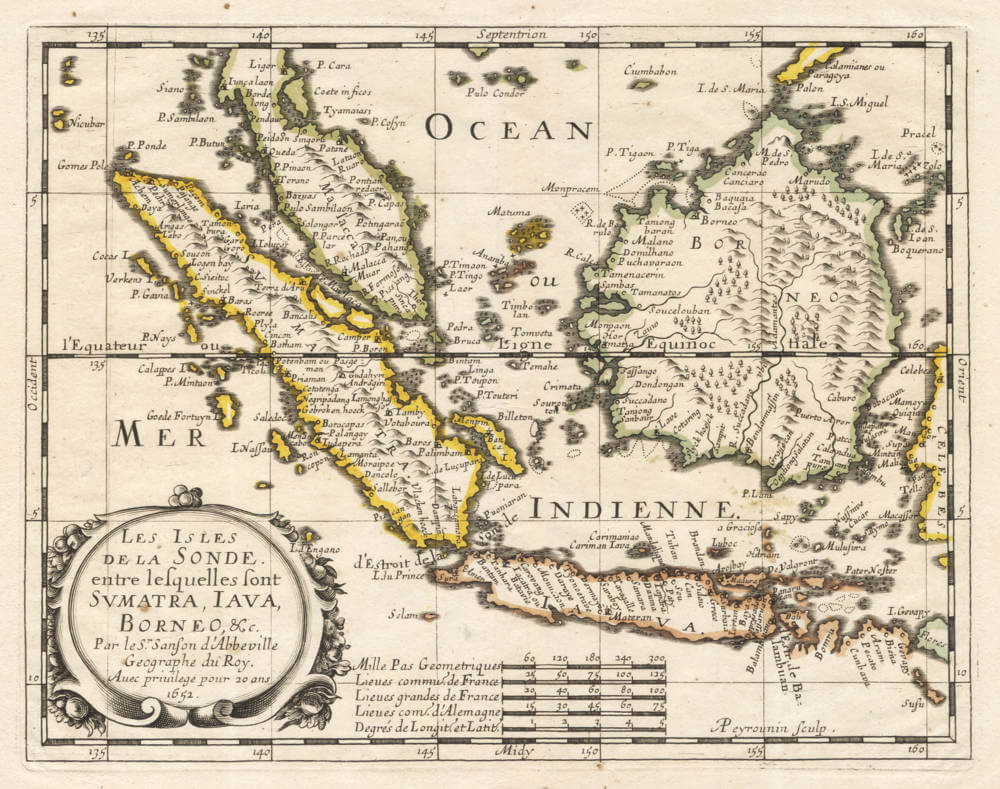
Description
A important map covering Indonesia, from the first 1652 edition of the atlas L'Asie en plusieurs cartes nouvelles, et exactes & en divers traittés de Géographie, et d'Histoire.
The maps were engraved by A. Peyrounin, and copied several times by various map publishers througout the century.
Nicolas Sanson was to bring about the rise of French cartography, although the fierce competition of the Dutch would last until the end of the century. His success was partly owing to the partnership with the publisher Pierre Mariette. In 1644 the latter had purchased the business of Melchior Tavernier, and helped Sanson with financial support in producing the maps.
Significance
First edition first state of this highly significant map of the region.
Rarity
The original French first edition is very rare.
Condition
Pristine example in attractive original colour.
Nicolas Sanson (1600-1667)
Nicolas Sanson was the foremost French mapmaker of the period.
Sanson was born in Abbeville where as a young man he studied history, particularly of the ancient world, and it is said that he turned to cartography only as a means of illustrating his historical work. For this purpose he prepared a number of beautifully drawn maps, one of which, after his move to Paris, came to the attention of Louis XIII. In due course the King appointed him ‘Géographe Ordinaire du Roi', one of his duties being to tutor the King in geography.
In the preparation of his major atlas, Cartes Générales de Toutes les Parties du Monde, Sanson employed a number of engravers, one of whom, M. Tavernier, engraved important maps showing the Post Roads and River and Waterway system of France (1632–34) and a map of the British Isles (1640). In all, Sanson produced about 300 maps of which two of North America were particularly influential: Amerique Septentrionale (1650) and Le Canada ou Nouvelle France (1656), the first map to show all the Great Lakes. After Sanson's death the business was carried on by his two surviving sons and grandson, in partnership with A. H. Jaillot.
It is generally accepted that the great age of French cartography originated with the work of Nicolas Sanson but credit must go also to A. H. Jaillot and Pierre Duval for re-engraving his maps, many still unprinted at his death, and re-publishing them in face of strong competition from the Dutch, who continued to dominate the market until the end of the century.