Leen Helmink Antique Maps & Atlases
www.helmink.com
de Laet
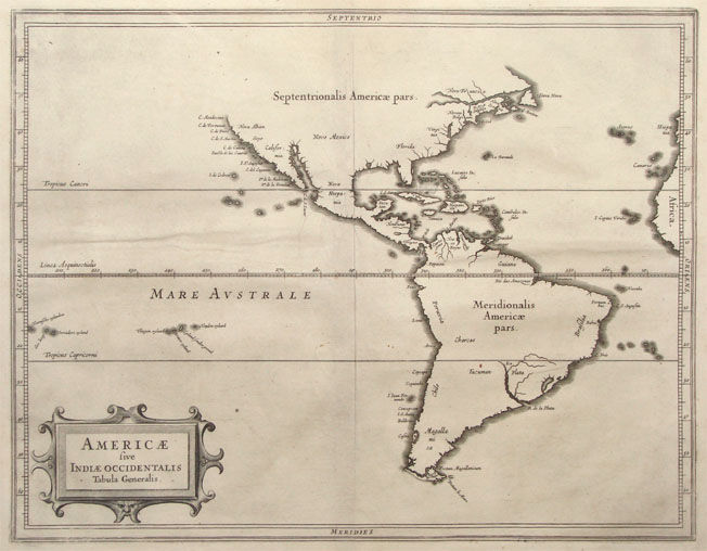
Americae sive Indiae Orientalis Tabula Generalis
Certificate of Authentication and Description
This is to certify that the item illustrated and described below is a genuine antique
map, print or book that was first produced and published in 1630, today 396 years ago.
July 26, 2026
Cartographer(s)
de Laet
First Published
Leiden, 1630
This edition
1630 first edition
Size
27.8 x 35.5 cms
Technique
Copper engraving
Stock number
18564
Condition
excellent
Description
Seminal early map of the Americas and the Pacific, by Hessel Gerritsz, arguably the best cartograper of the day, and offical map maker of both the East and West India Company.
It is the elegant overview map of what is only the second atlas devoted to the Americas (after the Wytfliet of 1597).
The map shows the latest discoveries of the Dutch in North America and in the Pacific.
Condition
First issue. Excellent collector's condition.
The Mapping of North America
Considerable effort went into making the text and maps of this work the most accurate available at the time. It is arguably the fines description of the Americas published in the seventeenth century. The exhaustive research involved de Laet reading all of the published and manuscript material that he could find.
For the cartographic work he had much to call on, being a director of the recently formed Dutch West India Company in charge of all Dutch interests in America and Africa. He therefore had access to the latest geographic knowledge.
He also drew upon the fine talents of Hessel Gerritsz, the official cartographer to the Dutch East India Company since 1617. This was a post he attained before Willem Blaeu under whom he was apprenticed, and who was his senior by ten years.
The maps were some of the first to depart from the heavier style of the Mercator and Ortelius period. This more open style of engraving was one that both Blaeu and Janssonius would develop in their atlases. The first edition of the book in 1625 contained ten maps which concentrated on South America. Since then the Dutch had taken considerable interest in New Amsterdam (New York), and the work was expanded by some 100 pages and four newly engraved maps.
The first of these additional maps is was a general one of the continent. Its most interesting feature is that although we know de Laet had seen maps of California as an island, he relies on the more trustworthy accounts, such as Herrera, in depicting a peninsular form. The map has the best west coast delineation to date. He also does not get drawn into the debate about the North West passage, preferring to cut his map short of these latitudes. It appeared in the subsequent editions in Latin, 1633, and French, 1640. In all of these there is no text on the reverse.
(Burden map 229).
Antique Maps - A Collectors Guide
In 1630 Johannes de Laet's volume L 'Histoire du Nouveau Monde ou Description des Indes Occidentalis included 14 maps engraved by Hessel Gerritsz. These fine maps are restrained in style but were the best of the period and influenced the subsequent maps of Blaeu and Jansson, particularly in the regions of the eastern seaboard of North America.
(Potter).
Joannes de Laet (1581-1649)
Johannes de Laet (Latinised as Johannes Latius) was one of the most important Dutch geographers, historians, and colonial administrators of the seventeenth century. Born in Antwerp in 1581 and raised in Leiden after the fall of Antwerp, he was educated within the humanist culture of the young Leiden University. Trained in classical languages and natural philosophy, he entered commerce rather than academia, spending years in London and Rouen and developing the international networks that later supported his scholarly and cartographic work.
De Laet’s decisive public role began in 1621, when he became a founding director (bewindhebber) of the Dutch West India Company (WIC). His fellow directors soon recognised him as the Company’s most informed authority on geography, ethnography, and overseas intelligence. A careful and empirical thinker, De Laet consistently argued for stable commercial expansion rather than purely military conquest. His access to reports, journals, pilot charts, and correspondence from Dutch Brazil, New Netherland, Guiana, the Caribbean, and the South Atlantic gave him an unparalleled documentary base with which to study the New World.
It is this wealth of primary material that enabled De Laet to produce his major scholarly achievement: the Nieuwe Wereldt ofte Beschrijvinghe van West-Indien, first published at Leiden in 1625. The work, expanded in several later editions, became the single most authoritative Dutch account of the Americas in the first half of the seventeenth century. Combining detailed descriptions of coastlines, peoples, flora and fauna, and natural resources with historical narratives of discovery, colonisation, and conflict, it offered European readers an unprecedentedly factual and wide-ranging synthesis of the New World.
A defining feature of the Beschrijvinghe, and a key reason for its enduring significance, is its suite of maps, executed by Hessel Gerritsz, the leading Dutch cartographer of his generation and official hydrographer of the VOC and the WIC.
Gerritsz had exclusive access to WIC archives, including pilots’ logs, reconnaissance charts, and intelligence reports that were unavailable to other European mapmakers. This resulted in some of the earliest reliable printed cartographies of the Caribbean, Brazil, the Guianas, and especially New Netherland.
Hessel Gerritsz (1581/82-1632)
Master engraver and Map Maker, who 'ruled' the Seas
Hessel Gerritsz. (1580/81) ranks among the most important and influential cartographers of the early-seventeenth-century Amsterdam. He started his career in Willem Jansz. Blaeu's workshop. About 1608 he established himself as an independent engraver, mapmaker and printer.
In his position as chart-maker of the Dutch East India Company (VOC) and West India Company (WIC) he had access to the latest ship logs, he equipped the ships to the east and the west with the latest charts, and was the best informed cartogrepher of the era.
(Schilder)
"Unquestionably the chief Dutch cartographer of the 17th century."
(Keuning)
His fame as cartographer grew rapidly to the point that on 16 October 1617 he was appointed the first exclusive cartographer of the Dutch East India Company (VOC), probably the most strategic position a cartographer could have in those days. He got the position by recommendation of Petrus Plancius, chief scientist and advisor of the VOC, who did not get along with the more senior Willem Blaeu. Gerritsz kept this post until his death in 1632, after which the position was given to Willem Blaeu after all (Plancius had passed away in 1622).
(Wikipedia)
In 1617, Hessel Gerritsz. published a large wall map of Italy in six sheets. His model for the geographical content was the wall map published by Giovanni Antonio Magini (1555-1617) in 1608, which was a milestone in the seventeenth century Italian cartography.45 He gave his wall map an extra cachet by extending the map image with town views and costumed figures. The design of the costumed figures is attributed to Pieter Lastman (1583-1633), the exquisite execution betraying the hand of the master etcher Gerritsz.
Gerritsz.' wall map of Italy was copied shortly after publication by the publishing house of Willem Jansz. [Blaeu]. To protect himself against such plagiarism in the future, he requested a patent from the States General. On 27 January 1618, they granted him a general patent in which amongst other things it was forbidden in any way to reproduce, copy or distribute his maps, descriptions of lands and prototypes ('models') both written or printed. Such an extensive patent was highly unusual, in the most cases a privilege was granted for precisely defined publications. Hessel Gerritsz. was so highly regarded in 1617, that he received such an important privilege from the States General in January 1618, shown by his appointment as instructor in geography for the Councillors of the Admiralty at Amsterdam on 15 July 1617 and as map maker for the Chamber Amsterdam of the VOC on 16 October 1617. With both appointments his old employer Willem Jansz. [Blaeu] was passed over.
With the appointment of Hessel Gerritsz. as map maker of the Chamber Amsterdam – a function which he held until his death in 1632 – the VOC brought a driven person into the house who undertook the organization of equipping the ships with charts and navigational aids with vigour. The instructions issued to him by the Chamber Amsterdam in 1619, give a good insight into what was expected from a map maker of the VOC. Because all merchants, masters and pilots were obliged to deliver the journals, maps and drawings made during the voyage to him on their arrival in Texel, with the aid of this material he was able to improve and expand the charts for the navigation to and from the Indies. The influential position that Hessel Gerritsz. held in equipping the VOC ships with charts cannot be overrated, for within a very short period he developed certain prototypes of charts, which – with some small adjustments – were part of the standard equipment of a VOC ship, sometimes until the middle of the eighteenth century.
(Schilder)