Leen Helmink Antique Maps & Atlases
www.helmink.com
Janssonius
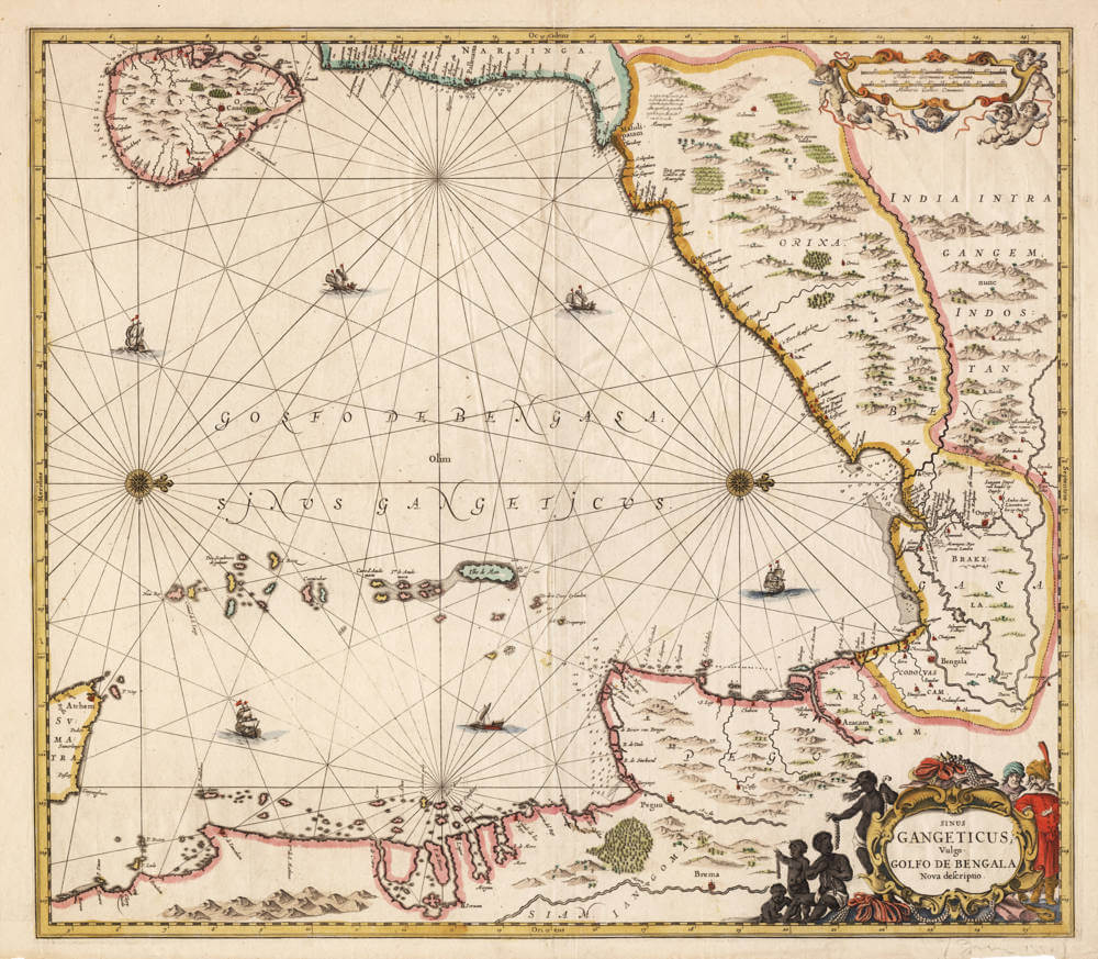
Sinus Gangeticus vulgo Golfo de Bengala
Certificate of Authentication and Description
This is to certify that the item illustrated and described below is a genuine antique
map, print or book that was first produced and published in 1657, today 369 years ago.
October 19, 2026
Cartographer(s)
Janssonius
First Published
Amsterdam, 1657
This edition
1650 first state.
Size
46.8 x 53.9 cms
Technique
Copper engraving
Stock number
19897
Condition
excellent
Description
This is one of the earliest printed sea-charts devoted to the Bay of Bengal, an attractive and sought-after chart by the great Amsterdam publisher Johannes Janssonius (1588-1664).
The sea chart is oriented with west at the top, so that north lies to the right. The chart embraces the whole of the Bay of Bengal: the island of Ceylon (Ceylon, with Candy) at the upper left, the Coromandel coast and the kingdom of Narsinga across the top, the provinces of Orixa and India intra Gangem, nunc Indostan down the right with Golconda, Bengala, and Dacca, the coast of Arakan (Aracam) and Pegu (Pegu) in Burma along the lower right, the kingdom of Siam (Siam) and the long peninsular coast toward the Strait of Malacca across the bottom, and the northern tip of Sumatra with Atchem (Aceh) at the lower left; the Andaman and Nicobar islands are below the centre, among them the Ilhe de Man and the Andeman group. The not well-known interior is embellished with mountains, forests, rice-fields, rivers, and towns, while the gulf is drawn as a working sea-space, covered with a fine web of rhumb lines radiating from two compass roses, dotted with soundings along the coasts, and enlivened with both European sailing ships and the smaller oriental vessels that plied these waters.
The Ganges estuary became a key hub for European trade in the 17th century, often called part of "Little Europe" on the Hooghly (Ougely) due to multiple colonial outposts along a short stretch of the river. The Dutch were prominent in the region and established a major presence near Hooghly, in Chinsurah (Chuchura). This was the main Dutch settlement, located adjacent to Hooghly. The VOC set up a trading post/factory here around 1635 (some sources note earlier activity from 1615 onward in Bengal). It became the headquarters for Dutch operations in Bengal by the mid-17th century. They traded in textiles (muslin, silk), opium, salt, spices, saltpetre, sugar, and more. Bengal was highly developed under the Mughals, making it a profitable area. The factory evolved into Fort Gustavus (or Gustava), a fortified settlement with warehouses, residences, and defenses. It was rebuilt and strengthened over time (e.g., walled in 1687, major work in the 1740s). A famous 1665 painting by Hendrik van Schuylenburgh depicts the bustling Dutch trading post at Hooghly, showing ships on the river, the factory compound, processions, and daily activity.
The title, held in a decorative cartouche at the lower right, reads Sinus Gangeticus, vulgo Golfo de Bengala, Nova descriptio (A new description of the Gangetic Gulf, commonly the Gulf of Bengal) and the open sea itself carries the legend Golfo de Bengala, olim Sinus Gangeticus, the gulf formerly called the Gangetic, a reminder that the bay had borne the name of the Ganges since antiquity. The title is decorated by pearl divers displaying their catch in long strings — an allusion to the celebrated pearl fisheries of these waters, above all the great fishery of the Gulf of Mannar between Ceylon and the Coromandel coast, whose pearls were among the most prized merchandise of the East.
A scale of Dutch and French miles (Milliaria Germanica Communia, Milliaria Gallica Communia) is held in a cartouche borne by putti at the upper right. The title cartouche at the lower right is flanked by local merchants and by pearl divers displaying their catch in long strings: an allusion to the celebrated pearl fisheries of these waters, whose pearls were among the most prized merchandise of the East.
This chart was published in Jansson's maritime atlas, the Waterwereld, which itself formed the first part of Volume V of his composite Atlas Novus, and was the first sea-atlas in the modern sense: a uniform collection of folio charts intended for general use.
This chart belongs to that atlas from its very first appearance: when the Waterwereld was first issued in 1650 it contained only four charts for the whole of Asia and its seas: a general chart of the Indian Ocean (Mar di India), Ceylon (Insula Zeilan), the Pacific (Mare Pacificum), and this chart of the Bay of Bengal. Thus, the Sinus Gangeticus stands among the very first printed sea-charts Janssonius devoted to the Asian waters. The regional charts of Java, Sumatra, and Borneo followed only with the Latin edition of 1659, and the chart of the Banda Islands later still.
Rarity
A foundational plate of the 1650 first state, among the earliest printed sea-charts of the Bay of Bengal; one of only four Asian charts in that first edition. The Janssonius plates were issued to about 1680; the present plate was later acquired, like much of the Janssonius stock, by Schenk & Valk, who re-issued it under their own imprint around 1700. Genuinely uncommon in the original Janssonius issues.
Condition
Excellent example of the first state, in vibrant original colour.
Johannes Janssonius (1588-1664)
Johannes Janssonius, more commonly known to us as Jan Jansson, was born in Arnhem where his father was a bookseller and publisher (Jan Janszoon the Elder). In 1612 he married the daughter of the cartographer and publisher Jodocus Hondius, and then set up in business in Amsterdam as a book publisher. In 1616 he published his first maps of France and Italy and from then onwards he produced a very large number of maps, perhaps not quite rivalling those of the Blaeu family but running a very close second in quantity and quality. From about 1630 to 1638 he was in partnership with his brother-in-law, Henricus Hondius, issuing further editions of the Mercator/Hondius atlases to which his name was added. On the death of Henricus he took over the business, expanding the atlas still further, until eventually he published an 11-volume "Atlas Major" on a scale similar to Blaeu's "Atlas Maior".
The first full edition of Jansson’s English County Maps was published in 1646 but some years earlier he issued a number of British maps in the Mercator/Hondius/ Jansson series of atlases (1636–44); the maps were printed from newly engraved plates and are different from the later 1646 issue and are now rarely seen. In general appearance Jansson’s maps are very similar to those of Blaeu and, in fact, were often copied from them, but they tend to be more flamboyant and, some think, more decorative.
After Jansson's death his heirs published a number of maps in an "Atlas Contractus" in 1666 and later still many of the plates of his British maps were acquired by Pieter Schenk and Gerard Valck, who published them again in 1683 as separate maps.
(Moreland and Bannister)