Leen Helmink Antique Maps & Atlases
www.helmink.com
Janssonius
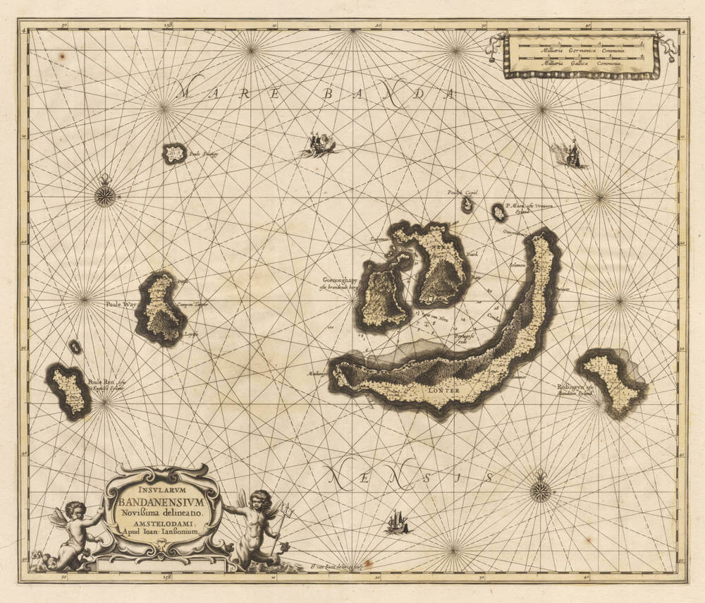
Insularum Bandanensium Novissima delineatio.
Certificate of Authentication and Description
This is to certify that the item illustrated and described below is a genuine antique
map, print or book that was first produced and published in 1664, today 362 years ago.
October 22, 2026
Cartographer(s)
Janssonius
First Published
Amsterdam, 1664
This edition
1664
Size
54 x 62 cms
Technique
Copper engraving
Stock number
19869
Condition
excellent
Description
This large-scale sea chart is the first to depict the Banda Islands, the small volcanic archipelago lying south of Seram in the Molucca (Maluku) group within the Banda Sea of present-day Indonesia. The composition is centred on the active volcano of Gunung Api and the adjacent central islands, with the channels between Lontor (Banda Besar), Neira, and Gunung Api carefully sounded, reflecting the chart's function as a navigational aid as much as a geographical record.
The cartographic significance of the chart is inseparable from the commercial and political history of the region. Until nutmeg cultivation was successfully established elsewhere in the tropics during the later eighteenth and nineteenth centuries, the Banda Islands were the world's sole source of nutmeg and its associated spice mace, both derived from the endemic Myristica tree; this monopoly of supply made the archipelago an object of intense European competition and lent strategic value to any accurate chart of its waters.
Geographical knowledge of Banda, Ambon, and Seram was deliberately controlled to protect the Dutch East India Company's commercial dominance, and the VOC enforced its monopoly with severity, including the destruction of spice trees on islands beyond its direct control.
To the west the chart includes Pulau Run (Poule Ron, ofte 't Engelse Eylant), the small nutmeg-bearing island that became the "genesis" of English overseas colonies and the British Empire. English East India Company vessels first reached the Bandas in 1603, and in 1616 the inhabitants of Run, fearing Dutch encroachment, formally pledged allegiance to the English Crown, the island being held for the Company under Captain Nathaniel Courthope until his death and the eventual Dutch ascendancy. By the Treaty of Breda in 1667, England formally ceded Run to the Dutch in exchange for the retention of Manhattan, a settlement that secured the VOC's nutmeg monopoly while confirming English possession of what became New York. The chart is a first hand document of a contested and economically pivotal corner of the early modern world.
The work was engraved by Johannes van Loon (1611-1686), a mathematician and astronomer who from 1650 collaborated with Joannes Janssonius and contributed plates to several of his cartographic projects, including the celestial atlas after Cellarius. The chart first appeared in the 1657 edition of Janssonius's maritime atlas, the Waterwereld, issued as the fifth volume of his Novus Atlas.
Following Janssonius's death in 1664, his heirs continued the firm until 1676, when much of the atlas stock and a number of the copperplates were dispersed; this plate ultimately passed to Pieter Schenk and Gerard Valk, who erased the original imprint and substituted their own, the resulting state bearing the line 'Apud P. Schenk et G. Valk. Cum privil.' and dating from about 1694 or later.
Significance
The first printed map of the Banda Islands, the sole source of nutmeg and mace. Based on VOC charts of the same.
Rarity
The rarest of all Janssonius charts of the East Indies.
When the Waterwereld first appeared in 1650 it carried only four charts for all of Asia (a general Indian Ocean chart, Ceylon, the Bay of Bengal, and the Pacific). The charts of Java, Sumatra, and Borneo were added only in the 1659 Latin edition; and this chart of Banda belongs to neither phase, appearing only as a later added map, issued after 1664 (Janssonius having died that year), with its latest recorded appearance c. 1680.
Its scarcity is compounded by that of the editions in which alone it occurs. Throughout the middle decades of the century the houses of Janssonius and Blaeu were locked in a sustained rivalry, each enlarging its atlas to outmatch the other, both building multi-volume editions of the Atlas Novus and the contest culminating in the Atlas Maior of either house. Blaeu generally held the prestige, and his crowning work, unlike that of Janssonius, contained no sea-atlas; yet many buyers preferred it even so, augmenting their Blaeu set with a separately published sea-atlas (for instance that of Pieter Goos} bound up to match, rather than purchasing the less fashionable Janssonius composite with its Waterwereld. The late Janssonius editions consequently sold in small numbers and survive in few complete sets, so that an added map found only in them, such as this chart of Banda, is hard to find. The plate was later acquired, like much of the Janssonius stock, by Schenk & Valk, who replaced the imprint with their own and re-issued the chart around 1700.
Johannes Janssonius (1588-1664)
Johannes Janssonius, more commonly known to us as Jan Jansson, was born in Arnhem where his father was a bookseller and publisher (Jan Janszoon the Elder). In 1612 he married the daughter of the cartographer and publisher Jodocus Hondius, and then set up in business in Amsterdam as a book publisher. In 1616 he published his first maps of France and Italy and from then onwards he produced a very large number of maps, perhaps not quite rivalling those of the Blaeu family but running a very close second in quantity and quality. From about 1630 to 1638 he was in partnership with his brother-in-law, Henricus Hondius, issuing further editions of the Mercator/Hondius atlases to which his name was added. On the death of Henricus he took over the business, expanding the atlas still further, until eventually he published an 11-volume "Atlas Major" on a scale similar to Blaeu's "Atlas Maior".
The first full edition of Jansson’s English County Maps was published in 1646 but some years earlier he issued a number of British maps in the Mercator/Hondius/ Jansson series of atlases (1636–44); the maps were printed from newly engraved plates and are different from the later 1646 issue and are now rarely seen. In general appearance Jansson’s maps are very similar to those of Blaeu and, in fact, were often copied from them, but they tend to be more flamboyant and, some think, more decorative.
After Jansson's death his heirs published a number of maps in an "Atlas Contractus" in 1666 and later still many of the plates of his British maps were acquired by Pieter Schenk and Gerard Valck, who published them again in 1683 as separate maps.
(Moreland and Bannister)
Johannes van Loon (1611-1686)
Joannes van Loon was an accomplished mathematician and astronomer. His first cartographic involvements were with Theunis Jacobsz during the 1640s. From 1650 he worked with Joannes Janssonius, engraving amongst other worksthe plates for his Celestial Atlas by Cellarius, 1660.
In 1661 he published his first work with his brother, Gillis; the 'Zee Atlas' contained thirty-five maps. In 1666 the plates were Jan Jansson van Waesberge, with whom he then co-published the atlas. This edition was expanded to forty-seven maps, and by 1676 there were fifty.
(Burden)