Leen Helmink Antique Maps & Atlases
www.helmink.com
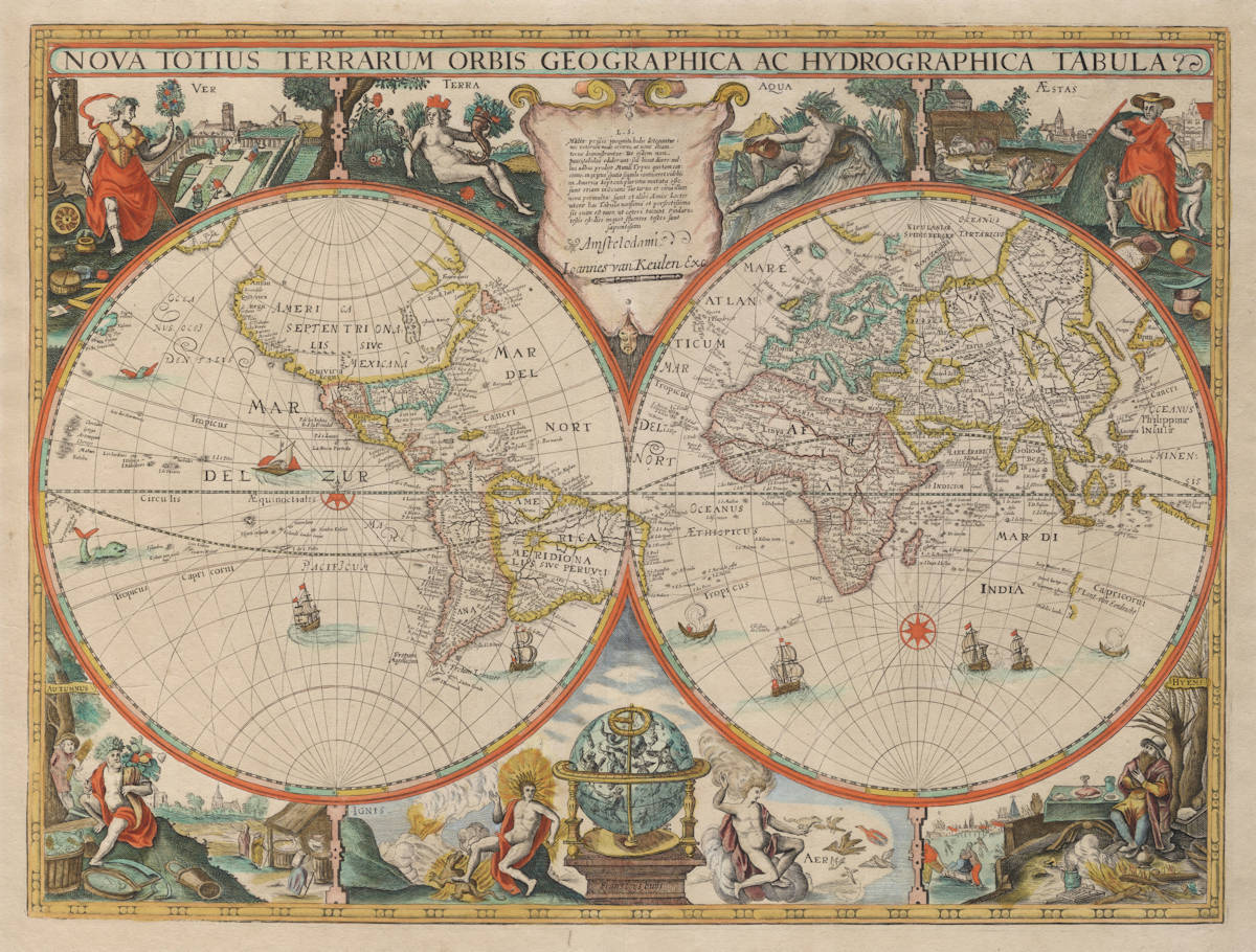
Jodocus Hondius II
NOVA TOTIUS TERRARUM ORBIS GEOGRAPHICA AC HYDROGRAPHICA TABULA
Certificate of Authentication and Description
This is to certify that the item illustrated and described below is a genuine antique
map, print or book that was first produced and published in 1621, today 405 years ago.
July 4, 2026
Cartographer(s)
Jodocus Hondius II
First Published
Amsterdam, 1621
This edition
1680
Size
41.5 x 54 cms
Technique
Copper engraving
Stock number
18995
Condition
excellent
Description
The first printed map to show any of the Dutch discoveries in Australia, made by Jodocus Hondius the Younger between 1621-24. Here in the 1680 state with the impressum of Johannes van Keulen. All states are of exceptional rarity.
A milestone in the cartography of the fifth continent and the beginning of the cartographical development and the mapping of Australia. Of the utmost rarity and significance.
(Günter Schilder)
Jodocus Hondius Jr.'s extremely rare world map of 1621-24 has the distinction of being the first printed map to show the discovery of the fifth continent, marking the beginning of the cartographical development and the mapping of Australia. The map is of the highest significance.
The double-hemisphere design, decorations, and cartography are modelled after Hondius’ own world map of 1617, which bore the same title and, in the eastern hemisphere on the great unknown south land, contained a dedication to Henry Briggs and Edward Wright.
The most striking innovation is the replacement of the vast Terra Australis Incognita, which had appeared in the southern oceans for centuries. In its place are the Dutch discoveries on the west coast of Australia between 1616 and 1619, recorded with the following names, which appear for the first time in print:
Iacop Remmer Rivier
Dirck hartogs ree
F Houtmans acbrooleus
’t Lant van Eendracht
Dedelis landt
The first discovery was made in 1616 by the Eendracht, commanded by Dirck Hartochsz. Although no logbooks survive, the discovery is confirmed by several contemporary letters. On 25 October 1616 the Eendracht sighted “several islands, though uninhabited” (“differente eylanden, doch onbewoont”). They anchored off present-day Dirk Hartog Island, where Hartog left a pewter plate inscribed to commemorate the landing (entries 15, 17). He named the new land after his ship, Eendrachtsland or Land of Eendracht, a name thereafter applied to much of the west coast.
In the following years more VOC ships unintentionally touched on the Australian west coast. In July 1619, the East Indiamen Dordrecht and Amsterdam sighted land at several points along the coast. The names F Houtmans acbrooleus [sic] and Dedelis landt record these contacts, referring to commander Frederik de Houtman and Councillor of the Indies Jacob Dedel. Also inscribed is Iacop Remmer Rivier, marking an otherwise undetermined incidental landfall of a VOC ship.
This geographical content derives from the VOC plane chart of the Indian Ocean by Hessel Gerritsz, first produced in 1621 (entry 18) and carried aboard all VOC East Indiamen. This is the only known earlier map to include the name “Iacob rēmens rivier,” establishing 1621 as the terminus post quem. Apart from the Indian Ocean on plane degrees, Gerritsz also equipped the ships with an additional Indian Ocean chart on Mercator projection, of which no early examples have survived, but which no doubt had the same information (see entry 101 for a later example). In 1622 the English East Indiaman Trial was wrecked on reefs that were quickly recorded on maps as Trial Rocks. News of this disaster could not have reached Amsterdam until 1623, explaining its absence from Gerritsz’s Indian Ocean chart and Hondius’ world map.
In 1623 the VOC sent an expedition to explore the Gulf of Carpentaria under the command of Jan Carstensz. As Hondius’ map does not yet show the Pera results (entries 25–27), even though these spread rapidly (entry 71), we must assume that they were not yet known in Amsterdam. The terminus ante quem is therefore 1624. Hondius’ map is thus dated securely to 1621–24 and stands as the first printed map of Australia.
Although the VOC did not publicise the discoveries in Western Australia, knowledge circulated rapidly. The Brouwer route, its sailing instructions and Indian Ocean charts with the Australian west coast were impossible to keep secret. Hundreds of VOC ships, crewed with Dutch and foreign steersmen, carried such charts and instructions, providing ample opportunity for copies to be made. To illustrate how quickly the information spread, the Royal Exchange successfully copied the route in 1620 for the British East India Company. As mentioned, Trial, the second English ship to attempt the route, was wrecked in 1622. The English then avoided the route for decades.
Hondius had intended this map for his world atlas, a project cut short by his premature death in 1629 (entry 28). The map is known in the following states, with unchanged cartography but different publisher’s imprints.
- State 1 - Jodocus Hondius [undated, but 1621–1624]
- State 2 - Franciscus Hoeius 1630
- State 3 - Clement de Jonghe 1664
- State 4 - Johannes van Keulen 1680
None were incorporated in regular atlases. The first state survives in only a single copy. The later states are of the utmost rarity, each surviving in only a handful of examples.
Significance
The map has the honour of being the first printed map to show the discovery of Australia.
Rarity
The map is known in four states, all of them as separate issues and of utmost rarity. The first state is only known in one single example. The map is lacking in all collections.
Condition
Thick paper, with ample margins. No restorations or imperfections. Attractive early colour. Overall a very fine and desirable collector's example of an unobtainable icon for any Australia collection.
Jodocus Hondius (1563-1612)
Jodocus Hondius II (son) (1594-1629)
Henricus Hondius (son) (1597-1651)
Jodocus Hondius the Elder, one of the most notable engravers of his time, is known for his work in association with many of the cartographers and publishers prominent at the end of the sixteenth and the beginning of the seventeenth century.
A native of Flanders, he grew up in Ghent, apprenticed as an instrument and globe maker and map engraver. In 1584, to escape the religious troubles sweeping the Low Countries at that time, he fled to London where he spent some years before finally settling in Amsterdam about 1593. In the London period he came into contact with the leading scientists and geographers of the day and engraved maps in The Mariner's Mirrour, the English edition of Waghenaer's Sea Atlas, as well as others with Pieter van den Keere, his brother-in-law. No doubt his temporary exile in London stood him in good stead, earning him an international reputation, for it could have been no accident that Speed chose Hondius to engrave the plates for the maps in The Theatre of the Empire of Great Britaine in the years between 1605 and 1610.
In 1604 Hondius bought the plates of Mercator's Atlas which, in spite of its excellence, had not competed successfully with the continuing demand for the Ortelius Theatrum Orbis Terrarum. To meet this competition Hondius added about 40 maps to Mercator's original number and from 1606 published enlarged editions in many languages, still under Mercator's name but with his own name as publisher. These atlases have become known as the Mercator/ Hondius series. The following year the maps were re-engraved in miniature form and issued as a pocket Atlas Minor.
After the death of Jodocus Hondius the Elder in 1612, work on the two atlases, folio and miniature, was carried on by his widow and sons, Jodocus II and Henricus, and eventually in conjunction with Jan Jansson in Amsterdam. In all, from 1606 onwards, nearly 50 editions with increasing numbers of maps with texts in the main European languages were printed.
(Moreland and Bannister)