Leen Helmink Antique Maps & Atlases
www.helmink.com
Pieter Goos
OOST INDIEN
Certificate of Authentication and Description
This is to certify that the item illustrated and described below is a genuine antique
map, print or book that was first produced and published in 1659, today 367 years ago.
October 23, 2026
Cartographer(s)
Pieter Goos
First Published
Amsterdam, 1659
This edition
1680
Size
47 x 85.5 cms
Technique
Copper engraving
Stock number
19877
Condition
excellent
Description
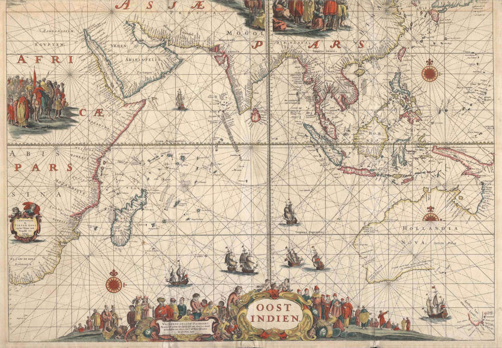
This is the large sea chart of the entire Indian Ocean, a Mercator-projection passage chart (wassende-graade paskaart) embracing the whole maritime sphere of the Dutch East India Company, here in the first state issued by Joannes van Keulen about 1680. As its title declares, it extends along the easternmost coast of Africa and the sea coasts of Asia from the Cape of Good Hope (C. de Bona Esperance) to Eso, north of Japan, taking in Arabia, Persia, India, the East Indies, the China coast, and the northern and western coasts of Australia.
The chart is a foundational document of Dutch maritime expansion in the East. Archival evidence indicates that it was drawn by the mathematician and cosmographer Dirck Rembrantsz van Nierop and first engraved about 1658 to 1660 for Pieter Goos, rather than being reworked from an existing plate; on this dating it is the first newly engraved chart to name all the Dutch discoveries along the Australian coast, from the earliest landfall of 1616 through to the momentous voyages of Abel Tasman in 1642 to 1644.
Gunter Schilder observed that the chart amounts to a complete survey of Dutch expansion in the East Indies and that it incorporates the results of Tasman's two expeditions. The coast of Hollandia Nova (Australia) is accordingly shown as established by Tasman, expressly noted as discovered in 1644 (Detecta Ao 1644), with the adjoining shore named Anthony van Diemens Landt and the southern continent's outline trailing off where exploration ceased.
The work is at once a navigational instrument and an emphatic decorative statement. Rhumb lines radiate from compass roses across the oceans, the equatorial line and the Tropics of Cancer and Capricorn are drawn across the sheet, and the seas are enlivened with numerous Dutch East Indiamen under sail.
The lower portion of the chart carries a large title cartouche set upon a shoreline thronged with merchants and figures of the various peoples of the East, alongside a second cartouche bearing the descriptive subtitle; ethnographic vignettes of Eastern peoples occupy the upper corners.
The plate is known in four states. The first, published by Pieter Goos about 1660, was followed by a second Goos state of about 1665 or later, in which the islands of Dina and Marseveen were added in the ocean to the south of the Cape of Good Hope. These are real islands, the sub-Antarctic group known today as the Prince Edward Islands (Marion Island and Prince Edward Island); they were sighted in the spring of 1663 by the VOC ship Maarsseveen under Commander Lam, who, rather than following the usual east-southeast heading of the Brouwer Route, which passed well to their north, stood sharper to the south to reach the roaring forties sooner and so came upon islands the conventional track had always bypassed.
The plate then passed to Joannes van Keulen, whose first state of about 1680, the present issue, retains the original imprint of Pieter Goos op het Water in de Vergulde Zee-Spiegel in the cartouche set into the African interior at the lower left and adds beneath it the line Seyn nu te Becoomen by Johannus van Kuelen, advertising the chart as now available from his house; the form Kuelen is one of the orthographic variants by which the name was written in the period. A second Van Keulen state of about 1700 is further distinguished by additional soundings along the West Australian coast, copied, very belatedly, from Hessel Gerritsz's pioneering chart of 't Landt van de Eendracht of 1627.
Charts of this kind were working instruments, equipping the Company's ships and requiring constant revision; the heavy attrition of shipboard use means that surviving examples are scarce, and impressions were issued both on durable vellum for use at sea and on paper for atlas and library use.
Examples are usually found cut short at the top, lacking the upper few centimeters along the top; the missing area is largely ornamental together with the China coast above Japan, while South-East Asia, the East Indies, and Australia remain intact. This trimming is caused by the constraints of binding the oversized sheet into atlases, or to the dimensions of the vellum, rather than to any deliberate revision.
As a record of the Dutch maritime world at its height, and of the freshly charted coasts of Australia, the chart ranks among the most important and decorative sea charts of the East Indies of its century.
Pieter Goos (1616-1675)
Pieter Goos: A Master Cartographer of the Dutch Golden Age
Early Life and Background
Pieter Goos, born in 1616 in Amsterdam, was a significant figure in the cartographic history of the Netherlands during the early 17th century. He was the son of Abraham Goos (1590–1643), who was also a renowned cartographer, map seller, and engraver. Abraham Goos had worked in Antwerp before moving to Amsterdam, where he contributed to the vibrant cartographic scene by publishing maps and globes, often in collaboration with other notable figures like Jodocus Hondius and Johannes Janssonius. This familial background provided Pieter with a rich heritage in mapmaking, setting the stage for his own illustrious career.
Pieter's mother, Stijntgen Theunisdaughter de Ram, and his family connections, including his uncle Pieter van den Keere, further immersed him in a milieu where cartography was not just a profession but a family tradition and skill. Growing up in Amsterdam during the Dutch Golden Age, a time when the city was a bustling hub of commerce, art, and science, Pieter was exposed to the latest techniques in engraving, printing, and map production from a young age.
Career and Contributions
Pieter Goos began his career following in his father's footsteps, initially focusing on creating pilot books which were essential navigational aids for sailors. These books included detailed charts and instructions for navigation, particularly around the Mediterranean, which were crucial for the Dutch maritime trade that dominated the period. His early work was marked by a notarized agreement with Jacob Lootsman and Hendrick Doncker to publish these pilot books, ensuring their validity and distribution from 1643 to 1680.
In 1666, Pieter Goos made a significant leap in his career with the publication of his "De Zee-Atlas ofte Water-Wereld" (The Sea Atlas or Water World), which is considered one of the finest maritime atlases of its time. This atlas was not only a compilation of the latest navigational knowledge but also a work of art, featuring richly colored maps with detailed illustrations of ships, compass cards, and wind roses. The atlas was so well-regarded that it dominated the Dutch market until the 1670s, when the Van Keulen family began to rise in prominence.
Goos's maps were known for their accuracy and aesthetic appeal, with embellishments like large descriptive cartouches that added to their decorative value. His work was not limited to sea charts; he also ventured into mapping land areas, with his atlas "Atlas ofte Water-Weereld" being noted for its comprehensive coverage of the known world's coastlines. Goos was innovative in his approach, being the first to map Christmas Island, which he named "Mony" on his 1666 map of the East Indies.
Legacy and Influence
Pieter Goos's influence extended beyond his lifetime. His son, Henrik Goos, continued the family tradition in cartography and publishing, ensuring that the Goos name remained synonymous with quality mapmaking. After Pieter's death in 1675, his widow managed the business for a short period, maintaining the high standards set by Goos. The maps created by Goos were used well into the 18th century, showcasing the enduring value of his work. However, later evaluations pointed out some inaccuracies, particularly in the depiction of geographical features like sandbars and islands in areas like the Gulf of St. Lawrence.
Goos's work was not just functional; it was also a status symbol. His atlases were printed on thick paper, often with gilding, making them desirable items for decoration in homes and offices of the affluent. This dual purpose of utility and decoration reflects the broader trend in Dutch cartography of the time, where maps served both practical navigational needs and the aesthetic tastes of the wealthy.
Conclusion
Pieter Goos's life and work encapsulate the spirit of the Dutch Golden Age's cartographic achievements. His contributions to navigation through his detailed sea charts and atlases helped solidify Amsterdam's position as a center of mapmaking excellence. His legacy is one of precision, artistry, and innovation, with his maps being both tools for explorers and collectors' items that adorned the walls of the era's elite. Pieter Goos passed away in 1675, but his impact on the field of cartography is still recognized today, with his maps being sought after by collectors and historians for their historical significance and artistic beauty.
Johannes van Keulen (1654-1711)
Gerard van Keulen (son) (1678-c.1727)
Johannes van Keulen II (grandson) (active 1726-1755)
The Dutch produced a remarkable number of enterprising and prolific map and chart makers but not even the Blaeu and Jansson establishments could rival the vigour of the van Keulen family whose business was founded in 1680 and continued under their name until 1823 and in other names until 1885 when it was from wound up and the stock dispersed at auction.
Throughout the history of the family, the widows several of the van Keulens played a major part, after their husbands' deaths, in maintaining the continuity of the business. The firm was founded by Johannes van Keulen who was registered as a bookseller in Amsterdam in 1678. In 1680 he published the first part of his 'Zee Atlas' which, over the years, was expanded to 5 volumes and continued in one form or another until 1734. More ambitious and with a far longer and more complicated life was his book of sea charts, the 'Zee-Fakkel', first published in 1681–82, which was still being printed round the year 1800. A major influence in the development of the firm was the acquisition in 1693 of the stock of a rival map publisher, Hendrik Doncker.
Although the firm was founded by Johannes van Keulen, he was primarily a publisher; it was his son, Gerard, a talented engraver, mathematician, Hydrographer to the East India Company, who became mainspring of the business which not only published charts but also books on every aspect of geograpy, navigation and nautical matters,
(Moreland and Bannister)
It was grandson Johannes van Keulen (II) who in 1753 produced Volume VI of the Zee-Fakkel for the VOC East Indiamen, containing printed charts for the navigation covering the waters from the Cape of Good Hope to Nagasaki . The atlas was not commercially sold and only for use on board of VOC ships, therefore it is also refered to as the 'secret atlas' odf the VOC. The engraving quality and craftmanship surpasses that of all earlier printed sea charts.
Sea charts from the secret atlas are among the rarest and most desirable sea charts for collectors.