Leen Helmink Antique Maps & Atlases
www.helmink.com
Coronelli
Mar del Sud, detto altrimenti Mare Pacifico
Certificate of Authentication and Description
This is to certify that the item illustrated and described below is a genuine antique
map, print or book that was first produced and published in 1690, today 336 years ago.
July 21, 2026
Cartographer(s)
Coronelli
First Published
Venice, 1690
This edition
Size
44.8 x 60.0 cms
Technique
Copper engraving
Stock number
18457
Condition
mint
Description
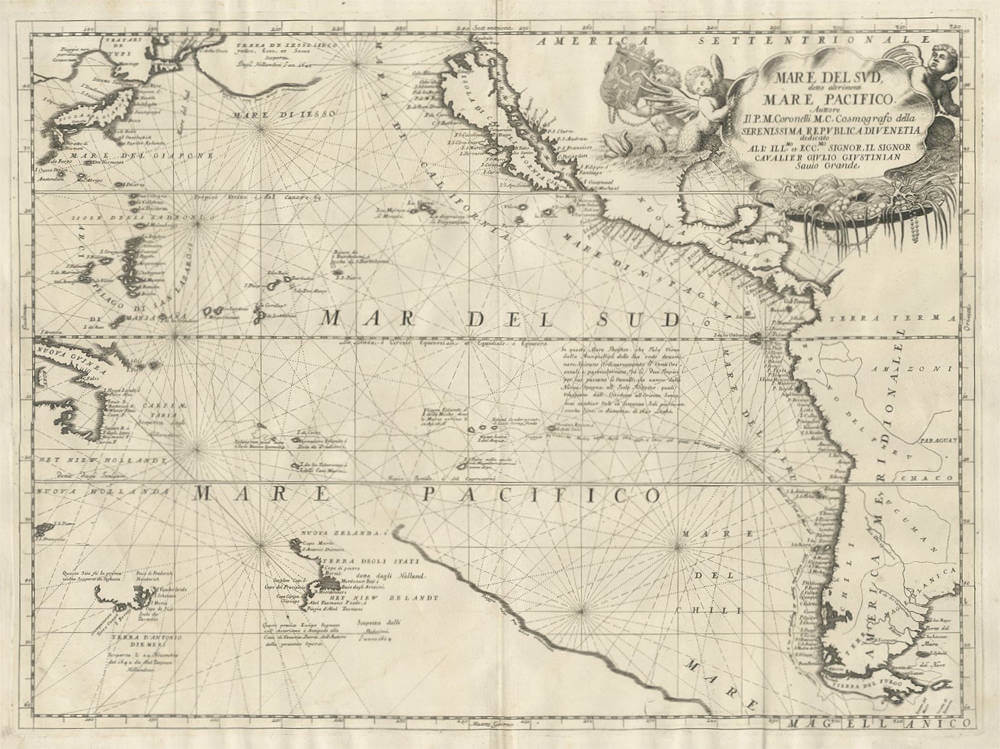
This is Vincenzo Maria Coronelli's map of the Pacific Ocean, engraved at Venice and issued in his Atlante Veneto during the 1690s. The map embraces the whole of the world's largest ocean, from the western coast of the Americas, traced from beyond California southward to Tierra del Fuego, across to the eastern margin where Tartary, Japan, the Ladrones, New Guinea, and the partially known coasts of New Holland, Van Diemen's Land, and New Zealand are shown. The Italian title preserves the older European name for the ocean, Mare del Sud or South Sea, which derived from Vasco Nunez de Balboa's first sight of its waters to the south after crossing the Isthmus of Panama in 1513.
Coronelli (1650-1718), a Franciscan friar who served as Cosmographer to the Republic of Venice and founded the Accademia Cosmografica degli Argonauti, was among the most accomplished cartographers and globemakers of his age, and the present map reflects both his ambition and the limits of geographical knowledge in his time.
It is in several respects a record of error as much as of discovery. California is shown as an island, a misconception that gained wide currency after about 1622 and persisted for decades; in the northern Pacific the lands reported by the Dutch navigator Maarten Vries are conflated, so that Yesso (Terra de Iesso, for Hokkaido) merges with the speculative Compagnies Land into a great landmass extending far towards America, with the Stretto Vriez named to its east. The outlines of Australia and New Zealand are necessarily those of the pre-Cook era, New Zealand trailing off into a coast not yet known.
The map is styled as a nautical chart, with rhumb lines radiating across the ocean and detailed coastal nomenclature, the western American shore alone carrying upwards of a hundred place names. Its principal track is that of Jacob Le Maire and Willem Cornelisz Schouten, who in 1615 to 1617 rounded Cape Horn to prove that Tierra del Fuego was insular rather than part of a southern continent, a route undertaken in part to evade the Dutch East India Company's monopoly over passage through the Strait of Magellan. Numerous legends record other voyages and observations, among them the Dutch reaching Terra de Iesso in 1643 and Australia in 1642, the discovery of New Zealand, the Spanish crossing from New Spain to the Philippines, and the trade winds and reckoned distances of the ocean passage. A note placed off the coast of New Zealand observes that the spot marked is antipodal to Venice, the author's own city.
The ornate title cartouche in the upper portion of the sheet is held aloft by nereids bearing a shell filled with marine treasures of seaweed, pearls, and coral, while a further figure displays the double-headed eagle of the Holy Roman Empire, its two heads looking east and west; the map is dedicated to the Venetian nobleman Cavalier Giulio Giustinian. The work stands as one of the most decorative and historically telling European maps of the Pacific of its century.
Vincenzo Maria Coronelli (1650-1718)
Ordained as a Franciscan priest, Coronelli spent of his life in Venice, becoming a noted theologian an being appointed, in 1699, Father General of his order. By that time he was already famous as a mathematician cartographer and globe maker and his influence led to a revival of interest in these subjects in Italy at the end of the seventeenth century. He was certainly the greatest cartographer of his time there and became Cosmographer to the Venetian Republic, taught geography in the University and, in 1680, founded the first geographical society, the Academia Cosmografica degli Argonauti.
In his lifetime he compiled and engraved over 500 maps including a large 2-volume work, the Atlante Veneto, somewhat reminiscent of Robert Dudley's Dell' Arcano del Mare; he is equally well known for his construction of very large terrestrial and celestial globes even finer than those of Blaeu, including one, 15 feet in diameter, made for Louis XIV of France.
(Moreland and Bannister)