Leen Helmink Antique Maps & Atlases
www.helmink.com
Matthijs Waterloo
NIEUWE KAART VAN BANDA
Certificate of Authentication and Description
This is to certify that the item illustrated and described below is a genuine antique
map, print or book that was first produced and published in 1795, today 231 years ago.
October 2, 2026
Cartographer(s)
Matthijs Waterloo
First Published
Banda, 1795
This edition
Size
56 x 76 cms
Technique
Manuscript on paper, watercolours and ink
Stock number
19977
Condition
excellent
Description
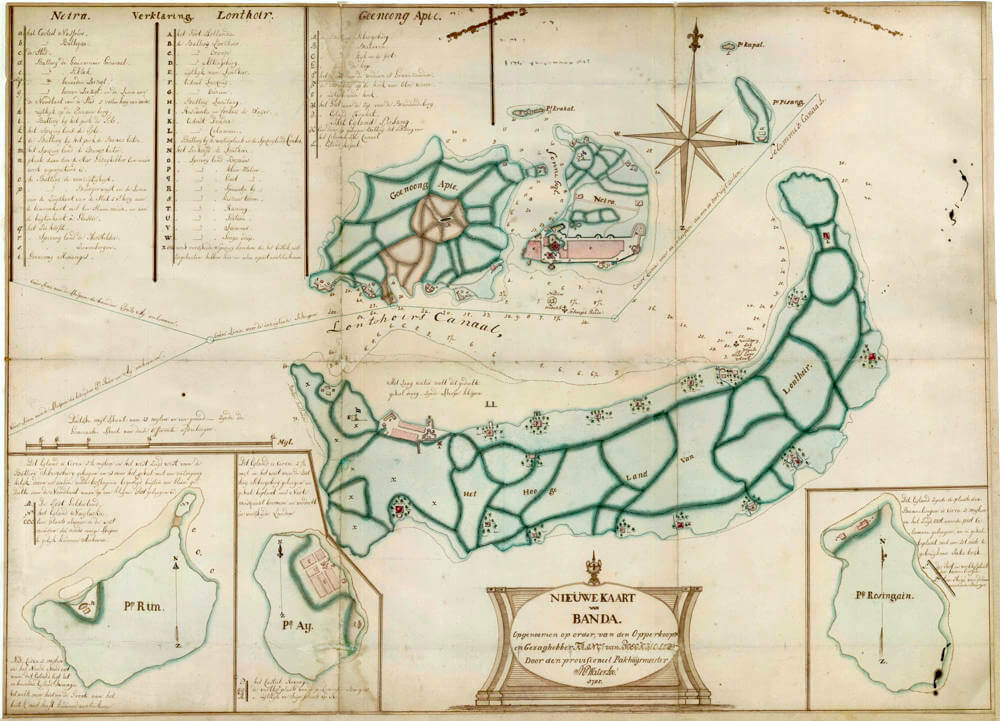
Nieuwe Kaart van Banda. Opgenoomen op order van den Opperkoopman en Gezaghebber Franc(iscus) van Boeckholster. Door den provisioneel Pakhuijsmeester M Waterloo. 1795.
Made by Matthijs Waterloo of Amsterdam, acting pakhuismeester (warehouse-master) of the VOC at Banda.
Commissioned by François van Boeckholtz (on the chart: Franciscus van Boeckholster), Opperkoopman and Gezaghebber of Banda, 1794–1796.
Covering the Governorate of the Banda Islands (Neira, Lonthoir, Gunung Api, Pulau Ai, Pulau Run, Rosingain and outliers), Moluccas.
Scale: Duitsche mijl, 15 miles to one degree (the German/Dutch geographical mile of 4 minutes of arc, c. 7.4 km or 4 modern nautical miles).
Orientation: North indicated by an eight-point compass rose with fleur-de-lis, upper right of the principal sheet.
Type: Hydrographic, cadastral and military chart of a VOC spice colony, with sailing directions.
Status: Unpublished unique manuscript. No printed counterpart of this survey is known.
This large manuscript is the last official Dutch survey of the Banda Islands executed while the Vereenigde Oostindische Compagnie still governed them. Drawn in 1795 on the order of the last VOC gezaghebber, it records the archipelago at the precise moment when the Company’s two-century nutmeg monopoly was about to end. Within months of the date on the cartouche, Rear-Admiral Peter Rainier’s squadron would take Banda Neira (8 March 1796) and the chart’s newly raised batteries would prove insufficient. As a working instrument it combines three registers that printed maps of Banda almost never unite at this scale: a hydrographic chart of the inner channels, a cadastral plan of the nutmeg perken, and a military inventory of forts, redoubts and the emergency batteries thrown up in 1795.
The Islands and the Monopoly
The Banda group is a cluster of small volcanic islands in the Banda Sea, some 140 kilometres south of Seram. Until nutmeg (Myristica fragrans) was successfully transplanted to other tropical colonies in the later eighteenth and nineteenth centuries, these islands were the world’s only source of nutmeg and of mace, the aril of the same fruit. That monopoly made an otherwise insignificant archipelago one of the most fiercely contested commercial prizes of the early modern world.
The Portuguese reached Banda in 1512, a year after Albuquerque’s capture of Malacca, but never established a fort. The Dutch followed at the turn of the seventeenth century. After the Bandanese orang kaya ambushed and killed forty Dutch officers at Fort Nassau in 1609, and after a bitter contest with the English East India Company for the outlying islands of Ai and Run, Governor-General Jan Pieterszoon Coen enforced a spice monopoly by conquest in 1621. The campaign reduced a population estimated at 13,000–15,000 to a remnant of perhaps a thousand, who were retained as forced cultivators; the productive land, some half a million nutmeg trees, was parcelled into sixty-eight perken of about 1.2 hectares and granted to Dutch planters (perkeniers): thirty-four on Lonthoir (Banda Besar), thirty-one on Ai and three on Neira. Slaves, convicts and indentured labourers were imported to work them. The VOC monopolized the export.
Run, the westernmost nutmeg island, occupies a special place in this history. English factors first landed there in 1603; in 1616 Captain Nathaniel Courthope obtained the islanders’ allegiance to James I, and Run is often described as the first English overseas colony. After Courthope’s death and a long Dutch siege the English withdrew. The Treaty of Breda (1667) confirmed the Dutch in Run in exchange for English retention of Manhattan, the famous swap of a nutmeg islet for New Amsterdam. The VOC, unable to police Run as tightly as the central islands, had already extirpated its nutmeg trees. On the present chart Run appears as an inset, described as overgrown with impenetrable thorn except for a small northern post, with the uninhabited island Swangie noted but omitted for want of space.
The 1664 printed chart
The first printed map devoted to the group is Johannes Janssonius’s Insularum Bandanensium Novissima delineatio, engraved by Johannes van Loon and issued after 1664 as a late addition to the Waterwereld, the maritime fifth volume of the Novus Atlas. That chart, based on VOC hydrography, is centred on Gunung Api and the sounded channels between Lonthoir, Neira and the volcano; it already marks Pulau Run as “Poule Ron, ofte ’t Engelse Eylant.” Geographical knowledge of Banda, Ambon and Seram was otherwise tightly controlled. The Janssonius plate is a navigator’s reduction of Company surveys. Waterloo’s 1795 sheet belongs to the same official tradition, but it is not a copy of the printed map. It is a new, large-scale survey made on the ground 130 years later, recording the mature perk landscape, the eighteenth-century forts and, decisively, the 1795 battery programme. Where Janssonius gives a first printed image of a still-contested archipelago, Waterloo gives the last Dutch manuscript image of a completed plantation colony on the eve of its surrender.
The authors and the date
The cartouche names two men. The survey was “opgenoomen op order van den Opperkoopman en Gezaghebber Franc(iscus) van Boeckholster” and executed “door den provisioneel Pakhuijsmeester M Waterloo.”
François van Boeckholtz (the form used in the VOC records and in later literature; the chart spells the surname Boeckholster and expands the Christian name as Franciscus) arrived at Batavia in July 1774 as a sergeant in the ship Dankbaarheid (Gratitude). He served as second resident, secretary and pay-bookkeeper at Surakarta from 1783 to 1789, drew Hindu antiquities in central Java, and is counted among the earliest European observers of Javanese archaeology. In 1794 he was appointed gezaghebber of Banda, the last Company governor of the nutmeg islands. News that Britain had gone to war with the Batavian Republic, and that a British expedition would almost certainly demand the Moluccas, reached him in 1795. The existing posts were weak. Van Boeckholtz therefore ordered a programme of new batteries and a survey that would show, on a single sheet, every channel, perk, watering-place and gun.
The draughtsman signs the cartouche “M Waterloo.” He is identifiable as Matthijs Waterloo of Amsterdam, who entered VOC service on 19 September 1784 as jongmatroos, noted als militair, in the hired fluit Dordrecht (formerly Berlin), Kamer Amsterdam. The Dordrecht left Texel that day and reached Batavia on 15 April 1785 (DAS voyage 4458.2). His scheepssoldijboek (NA, VOC 1.04.02, inv. 6731, fol. 80) then tracks him through Asia: Semarang in 1791; Banda in June 1795, the month of this survey, where the ledger abbreviation Ct is unresolved (capitein of a small detachment, commandant of a post, or constabel of the magazine); Batavia in 1797, after Rainier took Banda on 8 March 1796; Semarang in 1798; Yogyakarta in 1799; and Semarang again in 1801, when the account was left open, the usual fate of ledgers after the Company collapsed. The chart’s own rank, provisioneel pakhuismeester, is the better statement of his office on Neira. The pakhuis was the nerve of the monopoly: nutmeg and mace left the perken only through Company stores. An acting warehouse-master who could also survey was the natural author of a sheet that had to be at once a sailing directory, a plantation cadastre and a plan of defence. No other signed work by Waterloo has so far been identified; the present sheet is his monument.
The date 1795 is not a publisher’s imprint but a working date. Amboina surrendered to Rainier on 16 February 1796; the same squadron stood off Great Banda on 7 March and landed on the 8th under cover of HMS Orpheus and the armed ship Harlingen. Two batteries of two guns each exchanged fire and were silenced. Fort Nassau and the dependencies capitulated the same evening on terms similar to those granted at Amboina. The treasury yielded 66,675 rix-dollars; the warehouses 84,777 lb of nutmeg and 19,587 lb of mace. Van Boeckholtz obtained an honourable withdrawal. The VOC itself was already in liquidation: the Batavian Republic had replaced its directors in March 1796 and formally nationalised the Company on 17 March 1798. Waterloo’s chart is therefore both a last VOC document and a first document of the interregnum.
Cartographic construction
The sheet is composed as a working harbour plan rather than as a small-scale atlas map. The principal field is given to Lonthoir (Banda Besar), the crescentic “high land,” with Neira and Gunung Api (Goenoong Apie)
closing the inner channels to the north. Three inset plans occupy the lower margin: Pulau Run at left, Pulau Ay beside it, and Pulau Rosingain (so lettered on the inset; also Rosengain, Rosengeijn, Rozengain; modern Pulau Hatta) at right, each with its own short geographical note and lettered key. A title cartouche in the form of an architectural tablet, bottom centre, carries the full imprint. An eight-point compass rose with a fleur-de-lis stands above Neira. Course-lines for inbound and outbound shipping are drawn across the western approaches and annotated in a small formal hand.
The scale is the Duitsche mijl of fifteen miles to a degree, the German/Dutch geographical mile of four minutes of arc, approximately 7.4 kilometres or four modern nautical miles, expressly called “the general scale for all the sections.” Distances in the island notes (Ay 2½ miles west of battery Sibergsburg; Run 5½ miles west-southwest of the same; Rosingain 3 miles south-east of post Celamme) are given in this unit. Soundings, in vademen, fill Lonthoirs Canaal, the roads off Neira and the western approaches. A note in mid-channel records that a stretch of sharp rock dries at low water; another marks a “safe anchorage for a fleet” and a “newly discovered ship’s road.” Sailing directions distinguish ships coming north-about Pulau Ay, ships coming south-about Run and Ay, ships entering, and ships leaving to the east. The narrow north–south passage called Sonne Gat (Sun’s Gate) is so named because the sun stands in it at midday.
Land is washed in a cool green that also serves as a cadastral tint: the nutmeg gardens of Lonthoir are divided by brown tracks and field boundaries into named perken. Forts, batteries, redoubts, jetties and a few civilian buildings are picked out in rose or carmine, so that the military skeleton of the colony can be read at a glance. The three lettered keys, Neira (a–t), Lonthoir (A–X), Goenoong Apie (A–L), are written in a clerkly hand in the upper left, in the same ink as the toponyms.
The military landscape of 1795
The keys and the drawn works correspond, almost battery for battery, with the emergency programme recorded in the VOC histories of Banda. Van Boeckholtz’s additions, undertaken after the English declaration of war, are precisely the works this chart is concerned to locate.
On Neira the old pair of forts remains the core: Castle Nassau (a), the first Dutch fort, completed in 1609 on the abandoned Portuguese foundations of 1529; and Castle Belgica (b), begun in 1611 on the hill that commands Nassau, the most substantial European fortress in the Moluccas. Around them the key lists the town (c); the new battery “de Gouverneur Generaal” (d), thrown up below Nassau in 1795; batteries Tiktak, lower Zeezigt and upper Zeezigt (e–g), with an earthen wall five feet high on the north of the town; the look-out on the Paapenberch (h), the “Pope’s mountain,” a Dutch nickname recalling the earlier Portuguese and Franciscan presence; batteries and spice-fields at de Polo and Banco Batoe (i–m); a site where the governor had “projected new works” (n); battery De Voorzigtigheid (o); the Burgerwacht and the southern town wall, five feet of earth faced with stone on the inside and, on the outside, what the key describes as glass cullet or glasis (p); the sea jetty (q); and the spice-fields Herstelder and Zeevenbergen (r–s). Gunung Menangis (t) closes the Neira list.
On Lonthoir the key opens with Fort Hollandia (A), the inland redoubt built under Pieter Vlack in 1628 and strengthened again in 1795, and continues through batteries Lonthoir, Oranje and Altingsburg (B–D), the last of these raised in 1795 on the inner side at Batu Wolanda, the look-out of Lonthoir (E), redoubts Lacqouij, Ourien, Dender and Celamme (F, G, K, L), battery Laoulang (H), the residence and fortress De Waijer (I), the battery at the watering-place and perk Comber (M; the “Notenburg” of the written accounts), the sea jetty (N), and a long series of named nutmeg gardens: Bejauw, Klein and Groot Walim, Spaantje bij, Keizers toorn (“Emperor’s wrath”), Raning, Foetera, Sammer, Songie adap (O–W). Letter X stands for “several spice-fields more, that could not be drawn separately because of the scale.”
On Gunung Api the 1795 works dominate: batteries Sibergsburg, Batavia, Kijk in de Pot and De Kop (A–D), built to command the Lonthoirse Gat; the land of the widow ’s Gravezande (E); a battery at the hook of Oloe Weroe (F); the “burned hook” (G); the crater itself, “het Gat aan de top van de Brandende berg” (H); the islets Krakat and Piesang (I), the latter with a covering battery for the Selammelsche Canaal (K; battery Nederburg in the written sources); and Pulau Kapal (L). Pulau Krakat was armed specifically to cover the Zonnegat.
The insets complete the defensive and penal geography. Pulau Ay, 2½ Duitsche mijlen west of Sibergsburg, is “fully planted with nutmeg trees and divided into several fields,” with Castle Revenge (P), the fort taken from the English in 1616 and so renamed, the residences of perkeniers and burghers (q.q.), and a look-out and semaphore on the rocks (R). Pulau Run, 5½ miles west-south-west of the same battery, is almost abandoned: thorn and wild wood, a small outpost Gelderland (M) on the north, the islet Nailaka (N), and an anchorage usable by several ships in the west monsoon (O.O.O.). Pulau Rosingain, lettered on the inset itself and known in the printed tradition as Rosengain, Rosengeijn or Rozengain (modern Pulau Hatta), is introduced as “de plaats der Bannelingen,” the place of the exiles, three miles south-east of post Celamme on Lonthoir. The note continues that the island “is geheel beplant met een tot niets te gebruijkene Jatie bosch”: entirely planted with a jatie wood of no use whatsoever. Jatie is the ordinary VOC spelling of Malay jati, teak (Tectona grandis). After nutmeg had been stripped from the island in the 1630s to concentrate cultivation on Neira, Lonthoir and Ay, a teak plantation on the emptied ground would have been a plausible experiment; Waterloo’s verdict that the stand was worthless suggests that teak on thin coral-limestone soil in a small-island climate had grown stunted and crooked, yielding nothing worth felling as construction timber. The island’s other use was penal. Janssonius already marks it Bandieten Eyland (Bandit’s Island); Valentijn calls Rosingein the Banditen-eiland, where condemned men cut firewood and ship’s timbers and burned coral lime; later accounts still have convict gangs in the djati woods, lime kilns and brickyards into the nineteenth century. The 1795 key marks only the post and residence of the banished (S) and a civilian house (F). A resolution of 20 December 1695 had ordered Rosingain replanted with nutmeg, briefly with success; that revival is not what Waterloo records.
Hydrography and the inner channel
The chart’s first duty is to ships. Lonthoirs Canaal, the sheltered road between Lonthoir and the Neira–Api pair, is densely sounded and labelled. The inner harbour of Neira, historically the VOC roadstead, is shown with its jetty and the batteries that face it. Course-lines approach from the west around Ay and around Run, then turn into the channels; a separate line serves ships leaving to the east. The drying ledge of sharp rock in the canal, the “newly discovered road,” and the “safe anchorage for a fleet” are the annotations of a man who expected either a relieving squadron or an enemy one. In the event it was the latter. British accounts of 8 March 1796 describe a landing on the north side of Neira under cover of Orpheus and Harlingen, and an exchange of fire with two two-gun batteries: precisely the class of work Waterloo had just drawn.
Place names
A comparison with Janssonius’s 1664 Insularum Bandanensium is instructive. The printed chart already knows Lonthoir (Lontor), Neira (Nera), Gunung Api, Poule Ron / ’t Engelse Eylant, Poule Wai and Rosengeyn, and it sounds the inner channels. Waterloo’s sheet keeps that skeleton and fills it with the toponymy of a lateeighteenth-century plantation colony: perk names that are Dutch, Malay and occasional hybrids (Banco Batoe, Klein Walim, Keizers toorn, Songie adap); batteries named for Batavia, for governors-general (Altingsburg, Sibergsburg, De Gouverneur Generaal), and for local jokes (Kijk in de Pot, Tiktak); the Paapenberch; Sonne Gat; Selammelsche Canaal. The language of the keys is the language of the garrison and the pakhuis, not of the atlas publisher. That is the difference between a reduced printed derivative of mid-century VOC charts and a unique local survey drawn for the last governor.
Significance
The detail and historical moment gives the manuscript a documentary value that no other chart can match. It is the last image of Banda as a VOC spice colony, drawn in the year Britain went to war with the Republic. Made by order of the last Company governor, and showing the very batteries that would face Rainier’s landing the following March. It is at the same time the most detailed surviving graphic record of the perk system on Lonthoir, of the exile station on Rosingain (Janssonius’s Bandieten Eyland), and of the neglected English island of Run a century after Breda. For the history of cartography it stands at the end of the closed VOC tradition: a local officer’s chart, executed just as the Company itself was being wound up.
Rarity
Large-scale VOC manuscript surveys of the perken and batteries were never intended for publication; they were working papers of the gezaghebber and the pakhuis, and they survive, when they survive at all, in the Nationaal Archief and a handful of colonial collections. No second example of Waterloo’s 1795 survey has been located, and the sheet does not correspond to any printed derivative.
Condition
Condition is excellent for a working sheet. One horizontal and two vertical folds. The drawing remains strong, the wash legible, the lettering of the keys and cartouche excellent. At 56 x 76 cm it is of a size that implies table use in the governor’s house.