Leen Helmink Antique Maps & Atlases
www.helmink.com
Georges-Louis Leclerc, Comte de Buffon
Nouvelle Hollande. Carte des Déclinaisons de la Boussole levées par les ...
Certificate of Authentication and Description
This is to certify that the item illustrated and described below is a genuine antique
map, print or book that was first produced and published in 1776, today 250 years ago.
March 25, 2026
Cartographer(s)
Georges-Louis Leclerc, Comte de Buffon
First Published
Paris, 1776
This edition
Size
43 x 53.5 cms
Technique
Copperplate engraving
Stock number
19827
Condition
excellent
Description
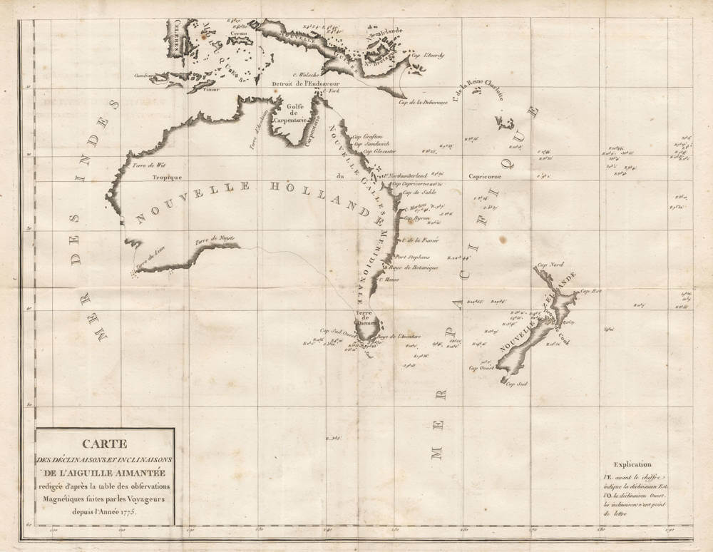
A French chart of Australia and New Zealand showing the discoveries made by Cook in 1770, during his first voyage and the discoveries made by Capt. Furneaux in Tasmania in 1773. Although complete in itself, the map is the lower-left corner of a larger four-sheet sea chart of the Pacific Ocean that could be joined.
This rare chart represents a significant early scientific mapping effort focused on magnetic declination in the vicinity of New Holland, the European designation for Australia during the eighteenth century. Compiled by the renowned naturalist Georges-Louis Leclerc, Comte de Buffon, the map draws upon navigational observations gathered by French explorers over the period 1771 to 1774.
Buffon, director of the Jardin du Roi and author of the monumental Histoire Naturelle, integrated this cartographic work into his Supplément à l'Histoire Naturelle, reflecting his broad interest in geophysical phenomena alongside biological classification. The chart meticulously plots isogonic lines—curves connecting points of equal magnetic declination—derived from compass variations recorded during voyages in the South Pacific and Indian Oceans.
Central to the map is the outline of New Holland, depicted with a conjectural eastern coastline extending southward, incorporating recent discoveries while leaving vast interiors unexplored. Van Diemen's Land (Terre de Diemen, Tasmania) appears as a detached entity, consistent with contemporary uncertainties prior to Bass Strait's confirmation in 1798.
Annotations detail declination values in degrees east or west, with intricate hatching denoting regions of easterly variation predominant around the continent. Buffon's synthesis amalgamates data from multiple expeditions, notably those under Yves-Joseph de Kerguelen-Trémarec, whose 1771–1774 voyage sought a southern continent and skirted Australian waters, as well as contributions from earlier navigators like Louis Antoine de Bougainville and Marc-Joseph Marion du Fresne. The involvement of Jean-François de Galaup, comte de La Pérouse, is implied through his early naval surveys, though his principal Pacific explorations postdate this chart; his later works would reference similar geomagnetic studies. Cartographically, the projection employs a modified mercatorial framework suited for navigational purposes, with north orientation. Coastal features include rudimentary sketches of bays and capes, such as those near the Great Australian Bight and the southwest coast, informed by Dutch charts and reconfirmed by French sightings.
The engraving, executed with fine precision typical of Parisian ateliers under Buffon's supervision, features delicate linework and shaded gradients to differentiate declination intensities. This map holds scholarly value as one of the earliest thematic charts dedicated to geomagnetism in Australasia, predating systematic surveys by Matthew Flinders and others. It underscores the Enlightenment combination of exploration, natural history, and applied science, wherein magnetic data aided longitude determination amid imperfect chronometers. Buffon's publication in 1776 disseminated these findings to European savants, influencing subsequent hydrographic efforts by the Dépôt des Cartes et Plans de la Marine.
Significance
This map holds important value as one of the earliest thematic charts dedicated to geomagnetism in Australasia, predating systematic surveys by Matthew Flinders and others.
Condition
Excellent collector's confition. Folded as issued.