Leen Helmink Antique Maps & Atlases
www.helmink.com
Willem Barentsz
Tabula hydrographica, in qua Hispaniae orae maritimae a civitate Setubal usque ...
Certificate of Authentication and Description
This is to certify that the item illustrated and described below is a genuine antique
map, print or book that was first produced and published in 1595, today 431 years ago.
July 30, 2026
Cartographer(s)
Willem Barentsz
First Published
Amsterdam, 1595
This edition
1595 first edition
Size
40.2 x 53.9 cms
Technique
Copper engraving
Stock number
19755
Condition
very good
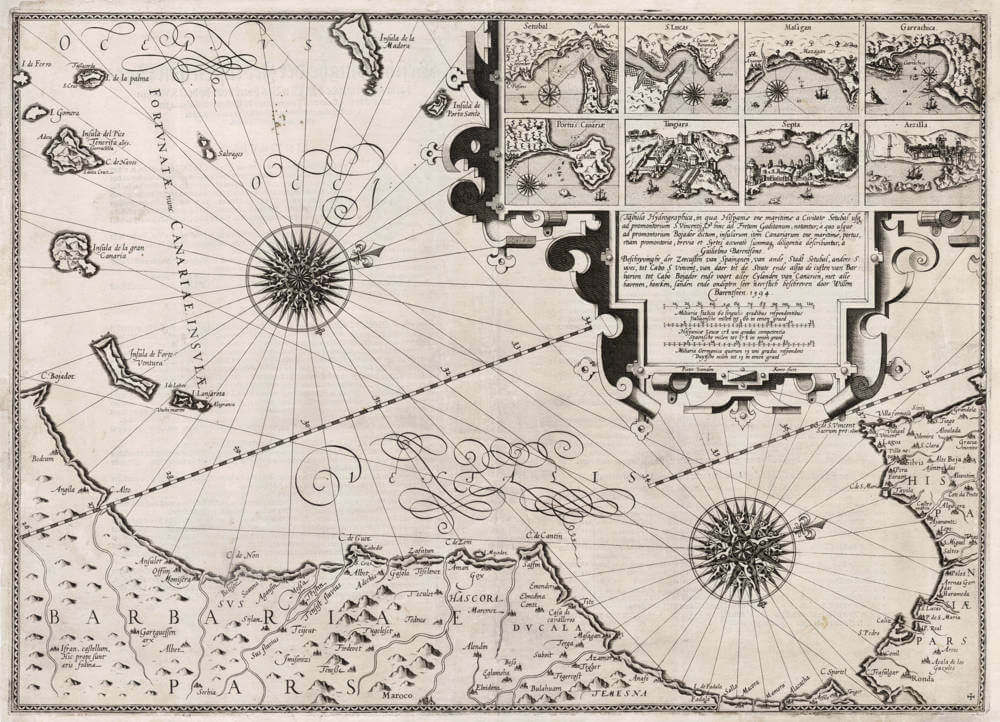
Description
The rarest and most splendid sea chart of the area, covering all the waters, capes and shoals from the Strait of Gibraltar, the coasts of Southern Spain and Portugal, Morocco down to Cape Bojador, the Spanish Canary Islands, and the Portuguese islands of Madera and Porto Santo. Among the most spectacular sea charts that the 16th century has to offer, and of extreme rarity.
The chart is from Willem Barentsz Caertboeck van de Midtlandse Zee ("Chart book of the Meditterrannean sea"), now of exceptional rarity. The copperplate is signed by Pieter van den Keere (Petrus Kaerius), one of the master engravers of the day.
The seas are adorned with elaborate swash lettering, two diagonal latitude degree bars, and two large compass roses. The upper right has detailed bird eye views of eight important sea ports along the coasts, framed in a spectacular strapwork cartouche that also features the title as well as three scale bars with Italian, Spanish and Dutch nautical miles, respectively. The following port cities are illustrated:
- Setubal (Setúbal in central Portugal)
- San Lucas (Sanlúcar de Barrameda, from where Magellan and Columbus set sail)
- Masagan
- Garrachice (Garachico in northern Tenerife)
- Portus Canariae (Las Palmas de Gran Canaria)
- Tangiara (Tangier)
- Septa (Ceuta, Spanish city in Morocco)
- Arzilla (Asilah, Portuguese city in Morocco)
The title is given in Latin first, followed by Dutch, as follows:
Tabula hydrographica, in qua Hispaniae orae maritimae, a civitate Setubal usque ad promontorium S. Vincentii, & hinc ad Fretum Gaditanum, notantur, a quo usque ad promontorium Bojador dictum, insularum item Canariarum orae maritimae, portus, etiam promontoria, brevia et Syrtes, accurate summaque diligentia describuntur a Guilielmo Barentsono.
[ Hydrographic Chart, in which the maritime shores of Hispania, from the city of Setubal even unto the promontory of S. Vincentii, & hence unto the Strait of Gades, are noted; from which even unto the promontory called Bojador, likewise the maritime shores of the Canary Isles, harbours, also promontories, shoals and Syrtes, are accurately & with utmost diligence described by Willem Barentsson. ]
Beschryvinghe der Zeecusten van Spaingnen, van ande Stadt Setubal, anders S. uves, tot Cabo S Vincent, van daer tot de Strate ende alsoo de custen van Barbarien tot Cabo Bojador ende voort aller Eylanden van Canarien, met alle havenen, hoecken, sanden ende ondipten seer neerstich beschreven door Willem Barentsoen. 1594.
[ Description of the Sea-Coasts of Spain, from the City of Setubal, otherwise Saint Uves, unto Cabo San Vincent, from thence unto the Strait (of Gibraltar) and also the coasts of Barbarien unto Cabo Bojador and further all the Eylands of Canarien, with all harbours, cliffs, sand shoals and shallows very diligently described by Willem Barentsson. 1594. ]
The chart is also known in a 1626 second state by Jansson, but with all decorations removed.
Rarity
With the Dutch merchant fleets dominating European maritime trade from the Levant in the southeast to Scandinavia and the Baltic in the north, Barentsz’s chartbook of the Mediterranean was highly successful and widely used. Because most copies served aboard ships, surviving examples of the charts and the book are today of the utmost rarity.
Condition
Strong and even impression of the copper plate. Thick and clean paper. A small area reinstated in the upper right border, into the view of the port of Arzilla, not affecting the map area. Overall a very desirable example of a chart that is lacking in nearly all collections.
Willem Barentsz (c.1550-1597)
Willem Barentszoon was a pilot and Arctic explorer who was convinced by the theorists of the day that it was possible to reach and China and the Far East via a North East passage through the Arctic. On his first voyage in 1594 accompanied by Jan Huyghen van Linschoten he reached Novaya Zemlya but was for back by ice: he failed again the following year. On his third voyage in 1596-97 his ship was trapped in pack ice and, although many of his crew survived in open boats, Barentsz himself died on the return voyage.
He is noted for this 1595 chart book of the Mediterranean, the first of its kind, which was complementary to Waghenaer's charts of the Atlantic coasts, and which is sometimes found bound up with the later editions of Waghenaer.
(Moreland and Bannister)