Leen Helmink Antique Maps & Atlases
www.helmink.com
de Bry
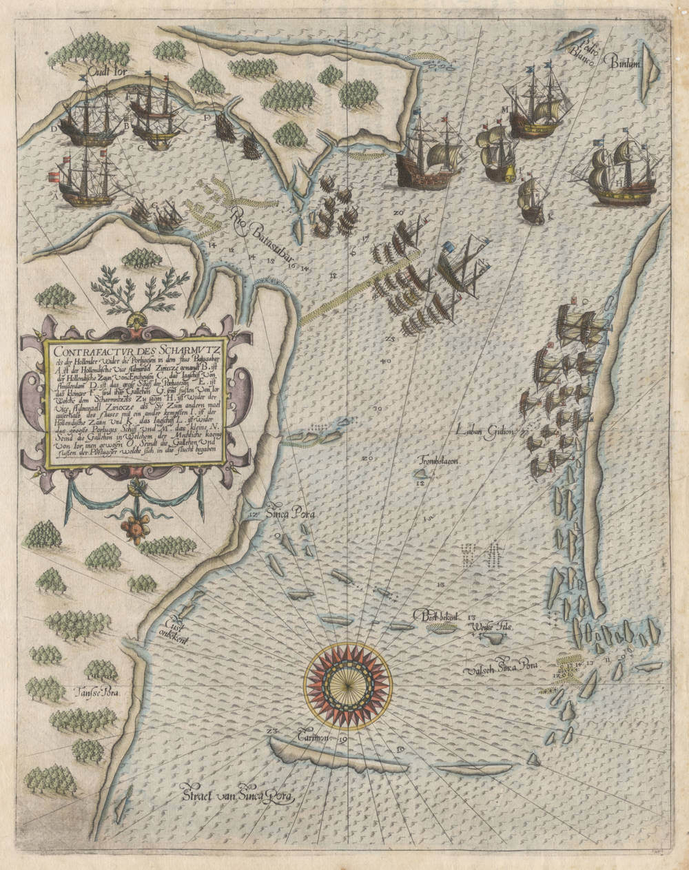
Untitled [Singapore]
Certificate of Authentication and Description
This is to certify that the item illustrated and described below is a genuine antique
map, print or book that was first produced and published in 1607, today 419 years ago.
July 16, 2026
Cartographer(s)
de Bry
First Published
Frankfurt, 1607
This edition
1607
Size
32 x 25 cms
Technique
Copper plate engraving
Stock number
19737
Condition
excellent
Description
The first and most desirable maps of Singapore, lacking in all collections.
North is on the left. Sinca Pura is in the center of the map, below it is Cust onbekent (Unknown coast).Valsch Sinca Pora (False Singapore) in the lower right. Oudt Ior (Old Johor) is at the top of the map, with Rio Batasubar (Johor River) leading up to it. Bintam (Batam} in the upper right. Below the large compass rose is Carimon (Karimunbesar Island), below that the entrance of Straet van Sinca Pora (Singapore Strait) is marked. The strait is filled with depth soundings and shoals/sand banks, as well as cliffs along the coasts.
1603 saw three major battles between the VOC and the Portuguese fleets. On February 25th the Dutch under Jacob van Heemskerck had captured the Santa Catharina here, the largest and most valuable prize ever taken by the VOC, the carrack and its cargo auctioned for over two million guilders in Amsterdam, significantly helping to fund the early VOC. A second sea battle took place in June, 1603. Shown here is the third and final sea battle of October 6-11 1603, giving the Dutch a decisive victory over the Portuguese and tipping thew balance of power in the region. The battle is also referred to as the Battle of Changi.
The elaborate text legend refers to the events in the battle and translates as follows:
REPRESENTATION OF THE SKIRMISH
when the Dutch fought the Portuguese in the river Bahusabar
A. is the Dutch Vice Admiral named Zirixcze
B. is the Dutch ship Zaun from Enkhuizen
C. the yacht from Amsterdam
D. is the large ship of the Portuguese
E. is the smaller one
F. are their galleys
G. are junks from Johor which came to pursue the skirmish
H. is again the Vice Admiral Zirixcze, as he at another time fought outside the river with another
I. is the Dutch ship Zaun
K. the yacht
L. is against the largest Portuguese ship
M. the small one
N. are the galleys in which the mighty king of Johor had been
O. are the galleys and junks of the Portuguese who fled
Theodor de Bry's Petits Voyages
The map appeared in Part VIII of Theodor de Bry's Petits Voyages, posthumously issued by his sons. There is a 1607 Latin edition of the book, and a German edition later that year, both have the same copperplate map of Singapore. There are no other editions.
The Latin edition, titled Indiae Orientalis pars octava, was published in Frankfurt by Wolfgang Richter for Johann Theodor de Bry and Johann Israel de Bry. It describes five Dutch voyages to the East Indies (led by Jacob van Neck, Jan Harmensz. van Bree, Cornelis Claesz., Wijbrant van Warwijck, and Steven van der Hagen) from 1598 to 1602, including accounts of locations, peoples, customs, and Ambon and Tidore. This first edition includes an engraved title page, 100 pages of text, and 18 engraved plates (some double-page), such as views of Singapore and Macao.
The German edition, titled Achter Theil der Orientalischen Indien, covers the same content and was published simultaneously (or slightly before) the Latin version in Frankfurt by Johann Theodor de Bry and Johann Israel de Bry. It was printed by Johan Saur and includes similar engravings, with the text translated into German to reach a broader Protestant audience in the Holy Roman Empire. This edition also dates to 1607, aligning with the brothers' practice of parallel publication for the first eight parts of the Petits Voyages (1597–1606/1607).
The Petits Voyages series (13 parts total, plus an appendix, published 1598–1633) focused on voyages to Africa and Asia, contrasting with the Grands Voyages on the Americas. German editions were issued for all 13 parts (with parts 1–8 by the de Bry brothers, 9–11 by Johann Theodor alone, and 12–13 by Matthäus Merian), often alongside Latin to maximize distribution, as Frankfurt was a key printing hub. No other languages were produced for Volume VIII.
Significance
This is the first map of Singapore. It is also of importance because it illustrates the rise of power of the Dutch East India Company in the region, at the expense of the Portuguese Empire.
Rarity
The map is of utmost rarity.
Condition
No restorations or imperfections. Excellent condition. A gorgeous example of a seminal map of the area.
Theodore de Bry (c.1527-1598)
De Bry was an engraver, bookseller and publisher, active in Frankfurt-am-Main, who is known to have engraved a number of charts in Waghenaer’s The Mariners Mirrour published in London in 1588. In that same year, also in London, an account was published by Thomas Hariot, illustrated by the artist John White, describing Raleigh's abortive attempt to found a colony in Virginia, and this was to be the inspiration for de Bry's major work, the series of Grands Voyages and Petits Voyages. In all, 54 parts of these two works were issued containing very fine illustrations and beautiful, and now very rare, maps, much sought after by collectors.
(Moreland and Bannister)