Leen Helmink Antique Maps & Atlases
www.helmink.com
Laurie & Whittle
Laurie and Whittle's New Chart of the Indian and Pacific Oceans Between the ...
Certificate of Authentication and Description
This is to certify that the item illustrated and described below is a genuine antique
map, print or book that was first produced and published in 1787, today 239 years ago.
June 10, 2026
Cartographer(s)
Laurie & Whittle
First Published
London, 1787
This edition
1800
Size
71.2 x 103.3 cms
Technique
Copper engraving
Stock number
19717
Condition
very good
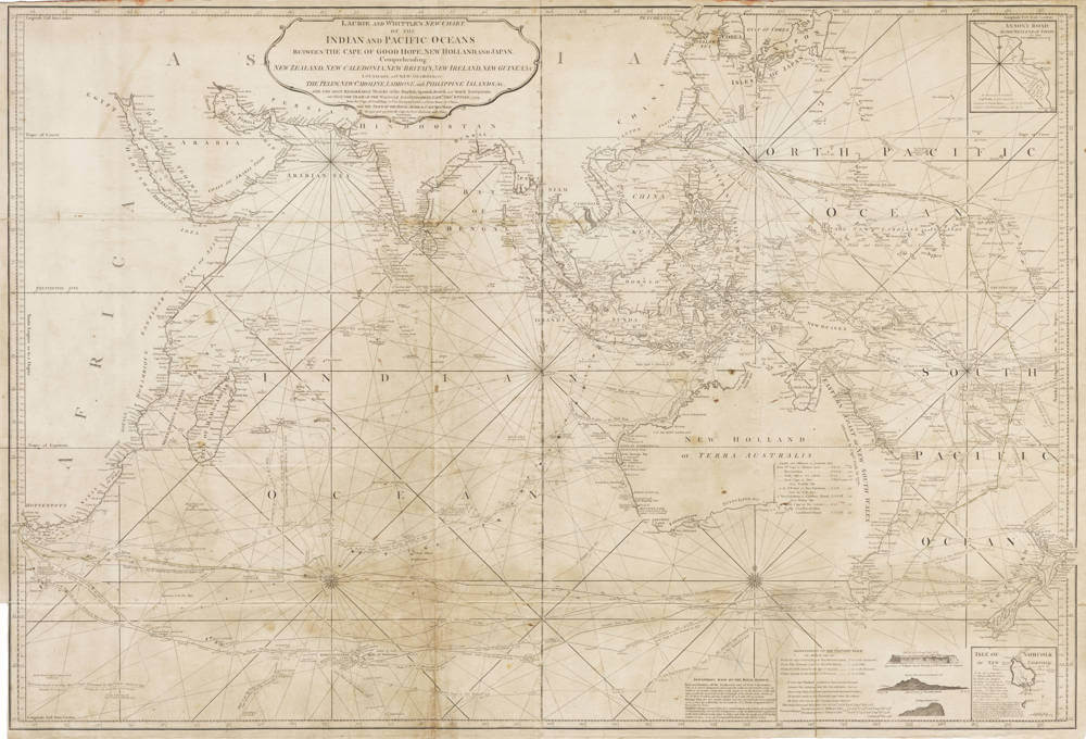
Description
A gorgeous oversized sea chart of the English East India Company for navigating the Indian Ocean from the Cape of Good Hope to Japan and from the Persian Gulf to New Zealand.
The chart was first published by Robert Sayer in 1787, and subsequently reissued by his pupils Laurie and Whittle in 1794 and in 1797 without much changes.
The 1800 state offered here adds significant additional information and seems to have been re-issued, without further changes for several more years, including a state dated 1803. It is one of the first charts to show Bass Strait, based on Flinders's explorations, proving that Tasmania (Van Diemen's Land) was a separate island and not parth of Australia's mainland.
Note on the Indian Ocean Chart Laurie and Whittle’s New Chart of the Indian and Pacific Oceans Between the Cape of Good Hope, New Holland and Japan (first published 1794, with notable editions in 1797 and 1800) was a landmark in maritime cartography. This two-sheet chart covered the Indian Ocean, Australia (New Holland), New Zealand, and parts of Southeast Asia, extending to Japan and Korea. It incorporated the tracks of key EIC voyages, such as the Walpole (1794) and Royal Admiral (1792–93), and was updated to reflect discoveries like the “Great Eastern Route” to China. The 1794 edition, based on Robert Sayer’s 1787 chart, included annotations from the Walpole’s voyage under Captain Thomas Butler, which added critical knowledge of routes via Van Diemen’s Land. The 1800 edition corrected earlier errors, such as depicting Tasmania as an island following the discovery of Bass Strait. This chart was part of The Country Trade East-India Pilot, dedicated to Marquis Wellesley, and featured coastal profiles, depth soundings, and rhumb lines, making it indispensable for EIC navigators.
The chart includes a fantastic early treatment of Australia (referred to as New Holland) and New Zealand, reflecting the discoveries in the last decades of the 18th Century. Insets describe the "Discoveries made by the Royal Admiral," "Observations on Walpole's Track" and the tracks and notes relating to many of the other 18th Century voyages of discovery in the Indian Ocean. Another insets shows a map of the island of Norfolk, as well as coastal profiles of Walpole Island, Norfolk Island and Phillip Island.
The toponyms in the south of Western Australia have been updated with "Lion's Land" named back to the original "Leeuwins Land", "South Cape" now named "C. Chatham", and adding "King George III Sound" and Land after George Vancouver's visit in 1791, and "D'Entrecasteaux's Islands" named after Antoine Bruni d'Entrecasteaux's discovery of these dangerous islands and shoals in late 1792, after a quest to find
the ill-fated expedition of Jean-François de Galaup, comte de Lapérouse.
The coastline of Australia is still incomplete, with annotations along the coast naming and dating the discoveries of various Dutch and Engish explorers.
The chart includes the following tracks:
- Torres (1606)
- Dampier (1688 Cygnet)
- Dampier (1699-1700 Roebuck)
- Hay (1739-Eagle)
- Bouvet (1739 Mary / la Marie)
- Carteret (1767 - Swallow)
- Bougainville (1768 - La Boudeuse)
- de Surville (1769 St. John Baptist)
- St. Allouarn (1772)
- Crozet (1772)
- Kerguelen (1772)
- Marion du Fresne (1772)
- Cook and Furneaux (1773 - Adventure)
- John Shortland (1778 - Alexander)
- Scarborough (1788)
- Larkins (1788 - Warren Hastings)
- Royal Admiral (1792-93)
- Walpole (1794)
Significance
The 1800 updated state of Laurie and Whittle’s New Chart of the Indian and Pacific Oceans Between the Cape of Good Hope, New Holland and Japan holds significant importance for its contributions to maritime navigation, particularly for the English East India Company (EIC), and its reflection of critical geographical discoveries, such as the confirmation of Bass Strait and Tasmania’s status as an island and the newly supported EIC trade routes around Australia. The EIC, which dominated global trade in commodities like tea, spices, and cotton, benefited from this updated route, enabling faster voyages between the Cape of Good Hope, Australia, and China.
Rarity
Even though the chart is occasionally found in the Sayer and Bennett / Laurie & Whittle East India Pilot, it is of utmost rarity, even more so when mounted on linen and used on board of East India Company ships for actual navigation.
This important 1800 state lacking in the National Library of Australia, who have the 1787 and 1797 states, but not his highly updated state of 1800 or its reissue of 1805.
Condition
Used on board for navigation with plotted ship's courses to and from the East Indies, in pencil and in ink. Linen backed as issued. Some mellowing of the paper, overall in very good to excellent condition for a used chart of this size.
Robert Laurie (c. 1755-1836)
James Whittle (1757-1818)
Origins and Formation
Robert Laurie (c. 1755–1836) and James Whittle (1757–1818) were pivotal figures in late 18th- and early 19th-century British cartography, particularly known for their contributions to maritime navigation through their work with the English East India Company (EIC). Their partnership, Laurie and Whittle, emerged as a dominant force in chartmaking following the death of their employer, Robert Sayer, in 1794. Sayer, a leading print and map publisher, had established a robust business at 53 Fleet Street, London, specializing in maritime charts and atlases. Laurie and Whittle began managing Sayer’s operations as early as 1787, taking full control in 1792 when Sayer’s health declined. Upon his death, they inherited a 21-year lease on the shop and the option to acquire Sayer’s stock and equipment for £5,000, payable over three years, forming the foundation of their enterprise.
Robert Laurie was a skilled mezzotint engraver with a background in portraiture and maritime chart production. Born around 1755, possibly in Dumfriesshire, Scotland, Laurie’s early career focused on engraving, but he shifted to business management upon partnering with Whittle. James Whittle, a charismatic London socialite and print seller, brought commercial acumen and a network of influential contacts to the partnership. His Fleet Street shop was a hub for intellectual and maritime communities, enhancing the firm’s visibility. Together, they transformed Sayer’s business into Laurie and Whittle, specializing in nautical charts and atlases critical for the EIC’s trade routes across the Indian Ocean, Southeast Asia, and beyond.
Contributions to the English East India Company
Laurie and Whittle’s work was integral to the EIC, which, by the late 18th century, was a global economic powerhouse, controlling vast trade networks and territories in the Indian subcontinent and East Asia. The EIC relied on accurate charts to navigate perilous routes, such as those from the Cape of Good Hope to China, through the Indian and Pacific Oceans. Laurie and Whittle inherited and expanded Sayer’s atlas business, notably producing editions of The Complete East-India Pilot and The Oriental Navigator, comprehensive collections of charts derived from surveys by EIC officers, Dutch manuscripts, and the work of French hydrographer Jean-Baptiste d’Après de Mannevillette. Their charts were renowned for their detail, incorporating depth soundings, rhumb lines, reef notations, and coastal profiles, which were essential for safe navigation. They published works like A New and Correct Chart of the Indian Ocean (1798), dedicated to Captain Joseph Huddart of the Royal Admiral, which included updates from his observations, improving navigation along the eastern passage to China. Their 1794 chart of the Gaspar Strait, derived from Huddart’s work, and their 1799 chart of northwest Java, based on Dutch and English surveys, exemplified their commitment to precision and practical utility for EIC mariners. These charts supported the EIC’s trade in commodities like cotton, silk, spices, and tea, which accounted for half of global trade in the mid-1700s and early 1800s.
Laurie and Whittle’s collaboration with EIC officers and other navigators ensured their charts reflected the latest discoveries. For instance, their 1794 chart of the Indian and Pacific Oceans included tracks of the Walpole (Captain Thomas Butler, 1794) and Royal Admiral (Captain Henry Bond, 1792–93), documenting new routes to China via Van Diemen’s Land (Tasmania). Their work also extended to regions like the Malacca Strait and the northern Indian Ocean, incorporating contributions from navigators like Pedro de Nova. By 1800, their charts began reflecting new discoveries, such as the determination that Tasmania was an island, correcting earlier maps that depicted it as part of mainland Australia.
Legacy and Evolution
The partnership thrived until 1812, when Robert Laurie retired, passing his role to his son, Richard Holmes Laurie (1777–1858). James Whittle continued until his death in 1818, after which the firm operated as Whittle and Laurie under Richard’s leadership. In 1858, after Richard’s death, the business was sold to Alexander George Findlay, eventually evolving into Imray, Laurie, Norie and Wilson Ltd., which remains the oldest surviving nautical chart publisher in Europe. Laurie and Whittle’s legacy lies in their meticulous charts, which facilitated the EIC’s dominance in global trade and laid the groundwork for modern hydrography.
Their work was not without challenges. The late 18th century saw intense competition from Dutch, French, and Portuguese navigators, and the EIC faced perilous routes fraught with storms, reefs, and uncharted waters. Laurie and Whittle’s ability to integrate contemporary surveys and annotations, such as those by Captain Isaac Whittemore on their 1800 Indian and Pacific Oceans chart, ensured their charts remained authoritative. Their publications, often dedicated to EIC figures like Marquis Wellesley, underscored their close ties to the company and its navigational needs.
Robert Sayer (1725-1794)
Early Life and Rise to Prominence
Robert Sayer (1725–1794) was a leading publisher of prints, maps, and maritime charts in Georgian Britain, renowned for his contributions to the English East India Company’s (EIC) navigational needs. Born in Sunderland, the youngest of three sons of lawyer James Sayer and Thomasine Middleton, Sayer entered the print and map trade through family connections. In 1747, his elder brother James married Mary Overton, widow of prominent mapmaker Philip Overton. By 1748, Robert took over Mary’s business at the Golden Buck, 53 Fleet Street, London, acquiring Overton’s stock, including plates from John Senex. Made a freeman of the Stationers’ Company in 1748, Sayer began publishing under his own name, initially focusing on decorative prints, caricatures, and topographical maps. His early work included a 1753 edition of Thomas Read’s Small British Atlas, marking his entry into cartography. Sayer’s business acumen and access to advanced production facilities allowed him to expand rapidly, adding stock from publishers like Henry Overton II, John Rocque, and George Willdey, establishing him as a key figure in London’s print and map trade.
Sayer’s early publications were diverse, ranging from mezzotints to novelty “metamorphosis” books for children, which featured interactive flaps revealing different scenes. By the 1760s, he began specializing in maritime charts, capitalizing on the EIC’s growing demand for accurate navigational tools to support its dominance in global trade, particularly in the Indian Ocean and East Indies. His collaboration with artists like Johan Zoffany, whose engravings he published, and his friendship with Zoffany, immortalized in the 1781 painting The Sayer Family of Richmond, enhanced his reputation. Sayer’s business thrived on imperial distribution channels, exploiting expanding markets in Britain and its colonies.
Contributions to the English East India Company
Sayer’s maritime charts were critical for the EIC, which controlled half of global trade in the mid-18th century through routes spanning the Indian Ocean, Southeast Asia, and China. His firm became the largest supplier of British nautical charts by the 1780s, producing works like A New and Correct Chart of the Indian Ocean, from the Cape of Good Hope to Canton (1787), which detailed the Arabian and Persian Gulfs, the China Sea, and newly discovered shoals and islands. This chart, drawn from journals of European navigators like Captain Hayter, included astronomical observations for precision, aiding EIC voyages to Canton and other trade hubs. Sayer’s charts incorporated surveys from EIC officers and foreign sources, such as French hydrographer Jean-Baptiste d’Après de Mannevillette, ensuring accuracy for navigating perilous waters.
In 1774, Sayer partnered with his former apprentice John Bennett, forming Sayer and Bennett, which boosted chart production. Notable works included The North-American Pilot (1775), featuring charts by James Cook, and A Compleat Map of the East Indies (1774), which mapped English territorial acquisitions from Persia to Borneo. These charts, often based on Samuel Dunn’s surveys, supported EIC navigation and British colonial ambitions. The partnership ended in 1785 due to Bennett’s mental health issues, after which Sayer increasingly relied on employees Robert Laurie and James Whittle. Sayer’s charts were known for their practicality, with detailed depth soundings, rhumb lines, and coastal profiles, essential for safe passage through reefs and currents.
Legacy and Transition
As Sayer’s health declined in the early 1790s, he delegated operations to Laurie and Whittle, who managed the firm from 1787 and took full control after his death in 1794. Sayer died in Bath on January 29, 1794, after a lingering illness, leaving his fortune to his second wife, Alice Longfield, and his son James from his first marriage. Buried at St. Mary’s Church in Richmond, where he owned a villa built between 1777 and 1780, Sayer’s legacy endured through Laurie and Whittle, who continued his chartmaking tradition, notably updating charts like the 1800 New Chart of the Indian and Pacific Oceans to reflect discoveries such as Bass Strait. Sayer’s business pioneered the commercialization of mapmaking, leveraging imperial networks to supply the EIC and other mariners. His firm’s evolution into Laurie and Whittle, and later Imray, Laurie, Norie and Wilson Ltd., cemented his influence on British hydrography, supporting the EIC’s trade dominance and shaping modern nautical cartography.