Leen Helmink Antique Maps & Atlases
www.helmink.com
van der Aa
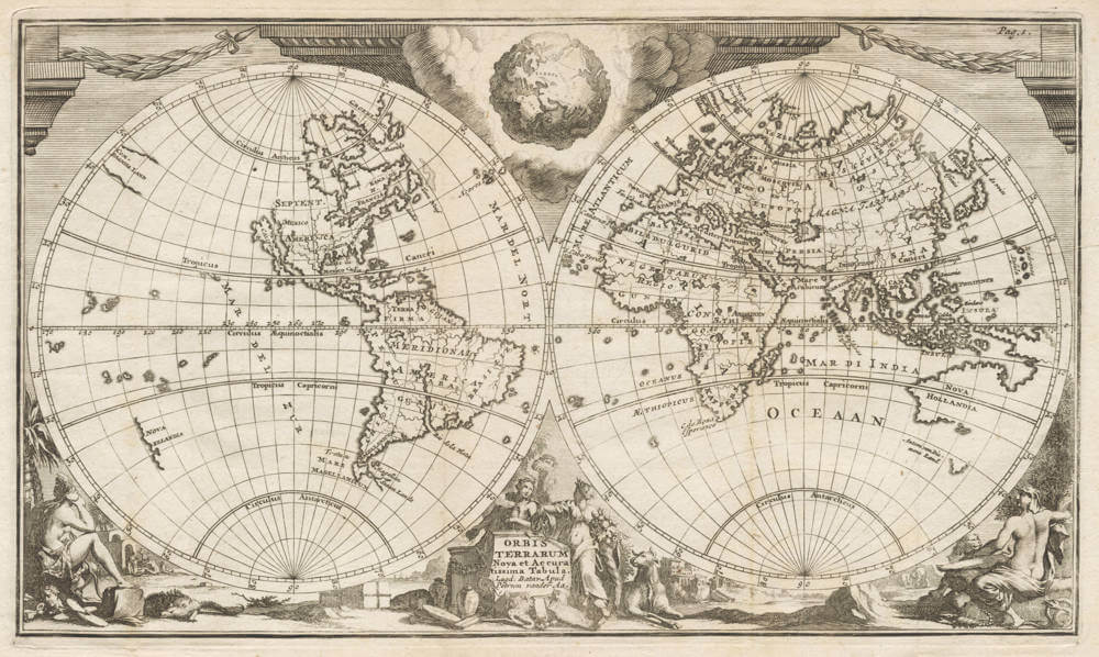
Nova Orbis Terrarum Tabula Accuratissima Tabula
Certificate of Authentication and Description
This is to certify that the item illustrated and described below is a genuine antique
map, print or book that was first produced and published in 1710, today 316 years ago.
July 31, 2026
Cartographer(s)
van der Aa
First Published
Leiden, 1710
This edition
1710
Size
17.0 x 29.5 cms
Technique
Copper engraving
Stock number
19283
Condition
excellent
Description
Elaborate double-hemisphere copper engraved map of the world. Shows California as an island, large "Compagnies Land" between the Asian and American continents, and unfinished coast lines of North-West America, Australia and New Zealand with Tasman discoveries. Many curious shaped areas, like Florida, South America, Japan, etc.
At the bottom of the map are allegorical female representations of the four continents. Above the map are garland-draped columns, and tucked between the spheres in a mass of clouds is a fascinating view of the earth as seen from space.
Further with animals and goods surrounding the title cartouche.
A highly sought-after beautiful and rare map in good condition.
Pieter van der Aa (1659-1733)
Records show that van der Aa, born in Leiden in 1659, made an early start in life by being apprenticed to a bookseller at the age of nine and starting his own in business as a book publisher by the time he was twenty-three.
During the following fifty years he published an enormous amount of material including atlases and illustrated works in every shape and size, two of them consisting of no less than 27 and 28 volumes containing over 3,000 maps and plates.
(Moreland & Bannister).