Leen Helmink Antique Maps & Atlases
www.helmink.com
Charles Le Normand
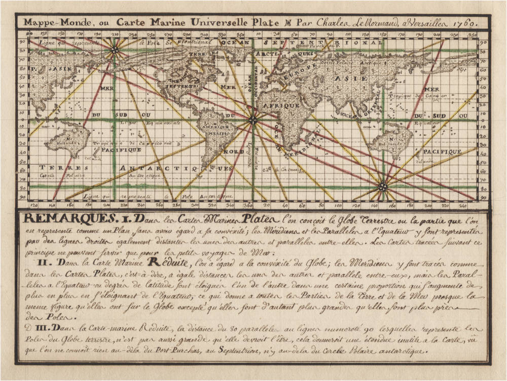
Mappe-Monde, ou Carte Marine Universelle Plate
Certificate of Authentication and Description
This is to certify that the item illustrated and described below is a genuine antique
map, print or book that was first produced and published in 1760, today 266 years ago.
July 13, 2026
Cartographer(s)
Charles Le Normand
First Published
Versailles, 1760
This edition
Size
21.0 x 15.3 cms
Technique
Manuscript
Stock number
19209
Condition
Excellent
Description
A fascinating 1760 French manuscript map of the world, with a special focus on Australia or Nouvelle Hollande, less than a decade before James Cook would explore it and fill in the blanks.
The map shows the strong interest of France in the exploration of the Pacific and the Indian Ocean, going even so far to show Australia twice (!), once in the east and once in the west, by showing longitudes 110-250 degrees twice, meaning almost 40% of the circumference of the earth, from the middle of the Indian Ocean to the middle of the Pacific Ocean is shown in both east and west, to give an unobstructed view of the sailing routes there using the southeast or southwest passage. Note that the northeast and northwest passage are also shown as navigable.
The map is very up to date for the time, including Cape Circoncisiona, a peninsula on the north-western edge of subantarctic Bouvet Island. The small peninsula was sighted by the French naval exploration that was led by Jean-Baptiste Charles Bouvet de Lozier on 1 January 1739, the Feast of the Circumcision day -- thus the name. The map features Port Purchas, the northernmost cape known at the time.
Below the map are three legends that explain the difference between map projections on increasing degrees vs flat projections as used here.
The map is drawn, signed, dated and annotated by Charles-Guillaume Le Normant d'Étiolles (8 May 1717 – 18 March 1799), who is best known as being the husband of Madame de Pompadour or Jeanne-Antoinette Poisson, the illustrious mistress of King Louis XV of France.
Condition
Thick paper, wide margins, no imperfections or restorations. Delicate original colour of the rumblines, the zero meridian, the equator and the Arctic and Antarctic circles. Pristine collector's condition.
Transcriptions and translations
Mappe-Monde, ou Carte Marine Universelle Plate.
World Map, or Universal Maritime Chart on plane degrees.
Par Charles Le Normand, a Versailles 1760.
By Charles Le Normand, Versailles 1760.
REMARQUES.
REMARKS.
I. Dans les Cartes Marines Plates l'on concoit le Globe Terrestre ou la partie que l'on en represente comme un plan, sans avoir egard a sa convexite; les Meridiens et les Parallelles a l'Equateur y sont representes par des lignes droites egalement distantes les unes des autres et parallelles autre-elles. Les Cartes tracees suivant ca principe ne pauvent servir que pour les petits voyages de Mer.
In Flat Marine Charts the Globe or the part of it which is represented is conceived as a plane, without regard to its convexity; the Meridians and Parallels to the Equator are represented by straight lines equally distant from each other and parallel to each other. The maps drawn according to this principle can only be used for small sea voyages.
II. Dans la Carte Marine Reduite, l'on a egard a la convexite du Globe; les Meridfiens y sont traces comme dans les cartes Plates, c'est a dire, a egale distances les uns des autres et parallele entre-eux, mais les Paralleles a l' Equateur ou degree de latitude sont eloignes l'un de l'autre dans une certaine proportion qui s' augmente de plus en plus en s'eloign... de l'Equateur, de qui donne en toutes les Parties de la Terre et de la Mer presque la meme figure qu' elles ont sur le Globe excepte qu' elles sont d' autant plus grandes qu' elles sont plus pres des Poles.
In the Redrawn Nautical Chart, the convexity of the Globe is taken into account; the Meridians are traced as in the Flat Charts, that is to say, at equal distances from each other and parallel to each other, but the Parallels to the Equator or degree of latitude are distant from each other in a certain proportion which increases more and more the further they are from the Equator. ... from the Equator, which gives in all the Parts of the Earth and Sea almost the same figure as they have on the Globe except that they are all the larger as they are nearer the Poles.
III. Dans la Carte Marine Reduite, la distance du 80 paralleles au lignes numerote 90 lesquelles represente les Poles du Globe terrestre, n'est pas aussi grande qu'elle devroit l'etre, cela donneroit une etendue inutile a la carte, vu que l'on ne connoit rien au-dela du Port-Purchas, au Septentrion, n'y au dela du Cercle Polaire antarctique.
In the Redacted Nautical Chart, the distance of the 80 parallels to the lines numbered 90, which represent the Poles of the Globe, is not as great as it should be, as this would give a useless extension to the chart, since nothing is known beyond Port Purchas, in the North, nor beyond the Antarctic Polar Circle.
Charles Le Normand (1719-1799)
Charles-Guillaume Le Normant d'Étiolles (8 May 1717 – 18 March 1799) is best known as being the husband of Madame de Pompadour or Jeanne-Antoinette Poisson, the illustrious mistress of King Louis XV of France.
A scion of a family of officials from Orléans, his father was Hervé-Guillaume Le Normant du Fort, trésorier général des Monnaies. His uncle was the financier Le Normant de Tournehem in 1741, a tax farmer and legal guardian of Jeanne-Antoinette Poisson. By arrangement of his uncle, Le Normant d'Étiolles married Madame de Pompadour in 1741. He also followed his uncle as a financier.
The couple had two children, a boy in 1741, who died the year following his birth, and a daughter, Alexandrine-Jeanne d'Étiolles, nicknamed "Fanfan", born on 10 August 1744. She died in June 1754 at the age of 9 years old from a stomach ailment, possibly peritonitis.
In June 1745, Louis XV, who had taken a particular liking to the enigmatic and beautiful Madame de Pompadour, (1721–1764) arranged for her to become his official mistress, a position she came by with the blessing of her husband's father. Louis XV offered Le Normant the position of ambassador to the Ottoman Empire, to remove him from the scene, but he refused. Louis then arranged a legal separation of Madame de Pompadour from her husband. He never forgave his wife for her treachery. He consoled himself with affairs with other women in Paris, having several children. After Pompadour's death, he discreetly married Marie-Aimée Maltha, formerly a dancer and the mother of his children, and they lived quietly at the manoir de Baillon, near the Royaumont Abbey.
He and his new wife were detained for over a year in the Reign of Terror. Later released, Charles-Guillaume died peacefully in his home on the rue du Sentier.
(Wikipedia)