Leen Helmink Antique Maps & Atlases
www.helmink.com
Coronelli
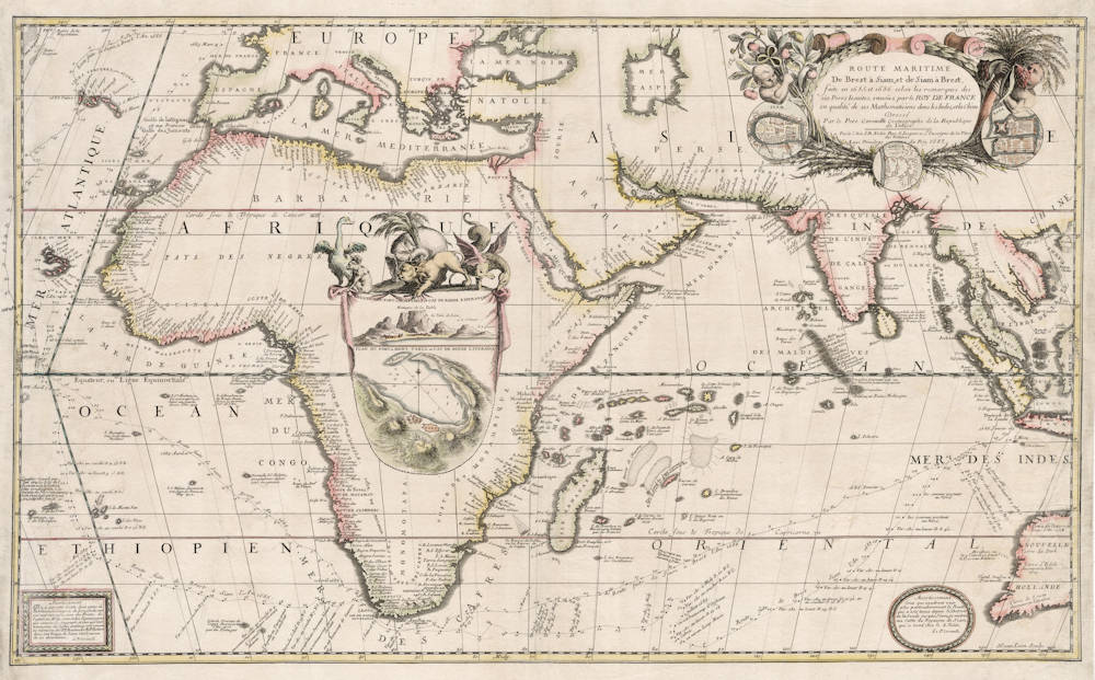
Route maritime de Brest à Siam, et de Siam à Brest, faite en 1685 et 1686 ...
Certificate of Authentication and Description
This is to certify that the item illustrated and described below is a genuine antique
map, print or book that was first produced and published in 1687, today 339 years ago.
July 31, 2026
Cartographer(s)
Coronelli
First Published
Paris, 1687
This edition
1687
Size
44.2 x 73.0 cms
Technique
Copper engraving
Stock number
19193
Condition
excellent
Description
Very rare and famous double-size sea chart detailing the maritime route of the famous French scientific expedition to Siam. The chart is sought-after for its decorative depiction of the Indian Ocean and surrounding lands, and is of particular importance to Thailand and to Australia.
Condition
Printed on two sheets of paper joined. A strong and even impression of the copperplate. Several paper restorations as often, especially on the left and right borders. The map was sold as a loose map and not included in any regular atlases at the time, which accounts for its rarity today, as well as for the usual imperfections.
Summary
The title cartouche in the upper right has inset plans of Siam (Ayutthaya), Batavia (Jakarta) and Louvo (Lop Buri), the town where Siamese King Narai the Great resided eight months a year and where the French build a celestial observatory to accurately establish the longitude of Siam, by observation of the eclipse of the moon of December 11th, 1685. The King was an enthousiastic participant in this event.
The expedition was endowed with a veritable laboratory, including several large telescopes ranging in length from 12 to 80 foot.
King Narai the Great was very open to foreign contacts. modern science, and cross-cultural exchange. He received and sent many foreign embassies, the Kingdom effectively closed its doors to foreigners after King Narai's death in 1688, and the French records provide most of what is known about the region from that period.
The chart here is a product of the collaboration between Jean-Baptiste Nolin, who was one of the official mapmakers to the King of France, Louis XIV, and Vincenzo Coronelli, who had been invited to Paris by the King to undertake cartographic projects, including the construction of a globe for the King. The result of this collaboration was the most up to date and detailed maps of many parts of the World at a time when France's explorations in America and Asia were of great importance.
The large cartouche in Africa is topped with a mythical gryphon, elephant, lyon, ostrich and a gorilla. It has a view and map of the Cape of Good Hope, of which the expedition also established the accurate longitude using another eclipse of the moon.
The route track of the outbound and inbound voyage is given in detail, with daily positions. It is the Indian Ocean "Brouwer route" that the VOC used for its mandatory sailing instructions. The track has interesting notes on observations of birds, sea lions, currents, calms, thunder storms, etc. The chart shows that the two ships ported in Batavia in early August 1685, two months after sailing from the Cape of Good Hope.
The coast of Australia lists and dates the Dutch discoveries there. It also includes the location and date of the famous shipwreck of VOC East Indiaman "Batavia" on the Abrolhos.
Vincenzo Maria Coronelli (1650-1718)
Ordained as a Franciscan priest, Coronelli spent of his life in Venice, becoming a noted theologian an being appointed, in 1699, Father General of his order. By that time he was already famous as a mathematician cartographer and globe maker and his influence led to a revival of interest in these subjects in Italy at the end of the seventeenth century. He was certainly the greatest cartographer of his time there and became Cosmographer to the Venetian Republic, taught geography in the University and, in 1680, founded the first geographical society, the Academia Cosmografica degli Argonauti.
In his lifetime he compiled and engraved over 500 maps including a large 2-volume work, the Atlante Veneto, somewhat reminiscent of Robert Dudley's Dell' Arcano del Mare; he is equally well known for his construction of very large terrestrial and celestial globes even finer than those of Blaeu, including one, 15 feet in diameter, made for Louis XIV of France.
(Moreland and Bannister)