Leen Helmink Antique Maps & Atlases
www.helmink.com
Loots / de Hooghe
No title [Nova Totius Orbis Tabula]
Certificate of Authentication and Description
This is to certify that the item illustrated and described below is a genuine antique
map, print or book that was first produced and published in 1707, today 319 years ago.
July 24, 2026
Cartographer(s)
Loots / de Hooghe
First Published
Amsterdam, 1707
This edition
Size
101 x 62 cms
Technique
Copper engraving
Stock number
19169
Condition
excellent
Description
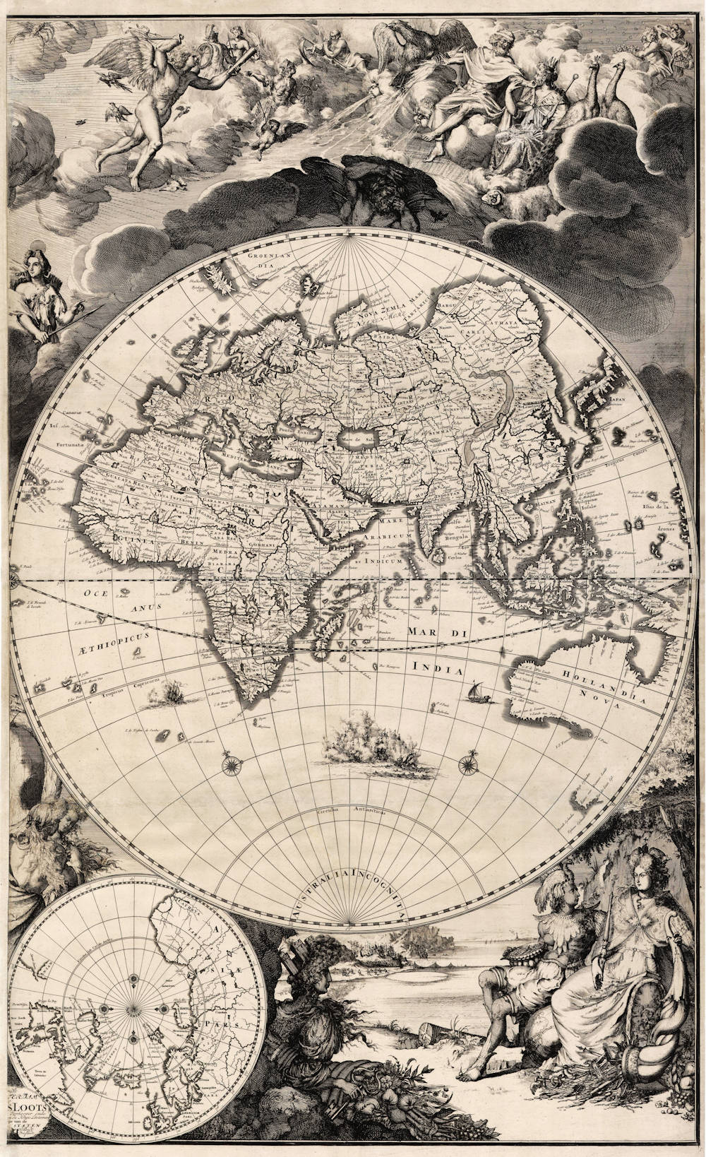
Unrecorded wall map by Romeyn de Hooghe
An unfinished and unknown large wall map of the world of high interest for the depiction of China and of Australia.
eastern hemisphere only
by Johannes Loots and Romeyn de Hooghe, 1707-1708
[ NO TITLE ]
[ Ged ] rukt |
[ tot AMS ] TERDAM |
[ b ] y |
[ IOHANNES ] LOOTS |
[ Boek en Kaart ] Verkooper inde |
[ Nieuwenbrugsteeg ] in de Jonge Lootsman |
[met privile ] gie van de |
[ HOOGMOGENDE ] STATEN |
[ van ] Hollandt |
[ en West ] Vrieslandt
Printed from two copperplates on two large sheets, joined.
Combinatined technique of copper engraved map and etched decorations.
Size of printed area height x width 101 x 62 cm.
Summary
This very large but unfinished and incomplete wall map of the world is a one-of-a-kind show piece of the 17th century Dutch cartography. No other example of this monumental work is known, nor any reference to it in the literature. Interestingly, the work is unfinished and shows only the eastern hemisphere.
This unique item is the result of a co-operation between the Amsterdam publisher and engraver Johannes Loots and the exceptionally talented artist and etcher Romeyn de Hooghe. The map is undisputedly one of the most beautifully decorated wall maps of the world, as well as a map that visualizes in an extraordinary way the cartographic development of the Far East and of Australia in the early Dutch discovery phase.
The map is the largest etching work known by the etcher Romeyn de Hooghe, and because it is unfinished it may well be his last work, because this project most likely started not before late 1707, whereas Romeyn de Hooghe died soon afterwards in mid 1708. A wall map like this, with rich decorations, was intended to serve as an impressive show piece to decorate the homes of rich VOC merchants in Amsterdam, and it would be an impressive show piece for any collection or exhibition today.
Prominent and double depiction of China
Because of its monumental size, the map shows a large representation of China (SINA) and Japan (IAPAN). The cartographic knowledge is very limited and confused, due to the distance and strict isolation politics of these countries. In southern China, the port of Guangzhou or Kanton is shown as Quangcheu. Nearby Macao is shown, where the Portuguese had their trading post. To the east the island of Taiwan (Formosa) is shown. We see the Yangtze River (Chekiang) and the old capitals of Hangzhou (Hengeheu) and Nangking. In the north, the capital of Peking (Xuntien) is shown in the province of Peking (Pecheli). The mysterious country of Korea (Corea) is depicted correctly as a peninsula. The Chinese wall stands out prominently. Inland China is highly inaccurate and mainly based on Jesuit sources. Little is known of central Asia. Cities along the Silk routes can be recognized (Samarchand, Tasjkent), as well as some of the vast deserts (Lop, Xamo) and the river of Ob (Oby). Curiously, China is shown twice, once as the newly discovered SINA in the east, and once as CATHAYA, the mysterious empire that Marco Polo had visited in the 13th century. It has Peking or Cambalu (Cumbalich) on the sources of the Ob river (Oby), and the imperial summer residence of Xanadu (Xandu) shown twice near the coast. The fruitless Dutch efforts to find a sea route to China by sailing along the north pole are visible in Novaya Zemlaya (Nova Zemla) where Willem Barentsz wintered in 1595. In the northeast is legendary Cape Tabin (Tibia promontoriumi Plinio), an unknown cliff that marks the furthest corner of Asia, according to the ancient theory by the Greek cartographer Pliny from classical antiquity.
Japan is largely unknown, despite having an important trading post of the Dutch East India Company there. The Japanese Shoguns maintained a policy where it was strictly forbidden to for foreigners to travel and to chart the country or its waters. The imperial city of Kyoto is shown by its old name Meaco.
Prominent depiction of Australia
Because of its monumental size, the map shows a large image of Australia (HOLLANDIA NOVA), bigger than on virtually all other printed maps of the day. The south-eastern part focuses all attention to the depiction of the recent Dutch discoveries in Australia with detailed results of the voyages of Abel Jansz. Tasman (1642/43 and 1644)) and his predecessors. Western Australia has all the discoveries, from north to south, G.F. de Wits Landt, ‘t Landt van de Eendragt, Dirck Hartochs Ree, Houtmans Abrolhos, Tortelduyf, I. de Edels Landt, and ‘t Landt van de Leeuwin. Southern Australia has ‘t Landt van Pieter Nuys, and the islands of I.S. Fancois and I.S. Pieter. In the lower right corner is Tasmania (Anthony van Diemens Landt) with West Eylanden, Boreels Eylanden, Tasmans Eylandt and Van der Lints Eyl. Of special interest is that the usual "unknown southern continent" (Terra Australis Incognita) has disappeared and the Antarctic areas are filled with water and a prominent AUSTRALIA INCOGNITA. Within the southern Indian Ocean, between South Africa and Australia, Romeyn de Hooghe has etched a spectacular naval battle scene with lots of ships, smoke of cannon fire, wreckage and drowning sailors. A smaller naval battle scene is in the southern Atlantic Ocean. A galley ship is off the coast of Western Australia.
Because it covers the whole eastern hemisphere, the cartographic image depicts the vastness of the Dutch East India Company (VOC) area at the summit of her power. The map shows all the waters of the VOC around the coasts of Africa, Australia and Asia starting from Europe in the upper left, the Atlantic Ocean, to the Cape of Good Hope (C. de Bona Esperanca), where the Dutch ships were obliged to anchor and call in, the Indonesian Archipelago, then all the way up to China and Japan. In the south, the cartographic image shows the vast Indian Ocean, that had to be crossed by VOC East Indiamen on their way from the Cape of Good Hope to Batavia.
The iconography by Romeyn de Hooghe
The large hemisphere map is surrounded by extensive decorations etched by Romeyn de Hooghe. As with many of De Hooghe’s works the design of the etchings is a complex one. It is not a random arrangement of decorative elements, but a carefully balanced scheme. The grand scene in the upper section of the map has an entirely mythological content, showing all the important gods of the Olympus, home of the gods of the upper world.
A depiction of a crab is visible as part of the zodiac in the upper left, which according to Greek mythology had been placed there by the goddess Juno (Hera). From left to right, the first figure we encounter is Diana, the goddess of the hunt and moon and birthing. She is depicted with her typical symbols hunting spear, bow and arrows and a moon disc over her head. The next figure is Apollo or the sun god, son of Zeus and twin brother of Diana. He is also associated with wisdom and medicine. The interpretation is somewhat mixed, because the torch he is carrying also refers to Prometeus, who stole fire from the gods to introduce to mankind. The man and women seated in the clouds behind Apollo are Mars, god of war, and Venus, goddess of love. He is easily recognisable by his helmet, sword and shield; she is
holding a burning heart of love. Going further, the figure in the clouds with the winged helmet and staff with intertwined snakes is Mercurius, messenger to the gods and protector of trade and negotiation. The large owl next to his feet is not just any bird, but she is the symbol of Minerva, goddess of wisdom and reason.
The old man with a scythe, eating a child, depicts Cronus (Saturn), the forefather of the classical gods, also god of agriculture and harvest, and a symbol of the passing of time and history. Because of a prediction that one day a mighty son would overthrow him, he ate all of his children when they were born to prevent this. Cronus’s wife Rhea hid her sixth her sixth child, Zeus, and offered him a large stone wrapped in clothes which he promptly devoured. Zeus later managed to overthrow him.
Next to him is Zeus (Jupiter) depicted with his symbols of the eagle and the flaming arrows of lightning. He is the king of all gods and ruler of the upper world.
Zeus is accompanied by his wife Juno (Hera), who was also his sister. She is the goddess of marriage. Her symbols, the two peacocks who stay together for life are next to her. She is depicted wearing a goatskin cloak to symbolize her warlike aspects.
Finally, the dark figure below all other gods is Pluto (or Hades), brother of Zeus and ruler of the underworld. He is equipped with large bat wings. While the upper world is a place of joy and light, the underworld is full of sadness and darkness. Here he also symbolizes the night (nocturnus), overshading the earth below.
Curiously, from all the important gods only Neptune (Poseidon) is missing, but it could be argued that this is a depiction of the Olympus or home of the gods. Because all other important gods are present, we
may wonder what allegories Romeyn de Hooghe had planned for the design of the upper part of the other hemisphere. One possibility is biblical scenes, or perhaps scenes from mythology.
At the bottom of the map is a depiction of the earth and the sea.
The figure seated in the centre, supporting the small polar map is Cybele, the earth-goddess and the goddess of towns, with her turreted crown and a large key to the city gates. She is also known as the city virgin, that serves as the allegorical depiction of the city of Amsterdam. Crowned with her tiara in the form of a city wall and holding the city key and a cornucopia on her lap, she symbolizes the power and wealth of Amsterdam.
The two figures, seated in the lower right corner, represent two of the four continents (the other two were no doubt intended for the design of the western hemisphere).
The woman on the right represents Europe or the Old World. She is depicted as a queen in full ornate dressing. She holds a Christian sceptre with a cross and a cornucopia which is filled with symbols of wealth and science, fruits, coins, crowns, tiaras and weapons. At her feet lies a large globe of the world. On her lap are books to symbolize wisdom and scales to symbolize justice.
To the left is America or the New World in the form of an Indian woman, depicted as a half-nude noble savage, wearing a feathered crown in the form of a peacock. She is holding a vase filled with gold or silver coins. Next to her feet is a roll of unprocessed tobacco.
In the background are maritime scenes, with detailed depictions of fishing and trading activities. A lighthouse is visible in the far right.
The map owes its beauty especially to its allegorical decorations, that were designed and etched by Romeyn de Hooghe. To assess and appreciate these allegorical scenes, it is essential to understand the importance of this etcher.
This work is the largest known etching from his hand and possibly his last work.
Dating of this unfinished wall map
This work of art is unrecorded, no other examples are known to this date, neither in collections nor in early references. It shows the eastern hemisphere only, there is no western hemisphere yet. The map engraving is signed by Johannes Loots from Amsterdam, his signature is in the small cartouche at the bottom left. The allegorical decorations around the map, as well as the naval battle scenes inside the map, are not signed but they are unmistakably the work of Romeyn de Hooghe. This work is also the largest known copperplate etching from his hand.
Curiously, the map is printed from copperplates that are not entirely finished and therefore this is a work in progress. The imprints are from very crisp and newly engraved copperplates, meaning that not many imprints had been made with it at the time of printing. While the engraving of the map image is complete, the etching work is not entirely finished yet, parts of it still need to be intensified with an engraving burin to emphasize the black contrasts. The lower right corner still needs to be filled in. Further, the hatched clouds near the border to the right of Asia suffer from a common etching error, caused by insufficient use of wax during the etching process, this would be corrected in a subsequent round of work. Above the title cartouche in the lower left is a laurel wreath that is not complete yet. This imprint is a proof state of a work in progress.
The history of this map is uncertain. Because no other examples are known, and because only the eastern hemisphere of the wall map is present, and because we have no contemporary references to this work, it is very well possible that this wall map project was never finished. The reasons for abandoning a big project like this have to be guessed.
When Johannes Loots was at the height of his fame and production, Romeyn de Hooghe was already near the end of his life. One possible explanation is that this is Romeyn de Hooghe’s final work, and that he died before finishing this work. If this was a project that Loots initiated sometime after finally dissolving his troublesome contractual cooperation with Claas de Vries on Sept 17, 1707, this is plausible because Romeyn de Hooghe died within nine months of this, on June 10, 1708.
Johannes Loots (1665/66-1726)
The publisher Johannes Loots was born in Amsterdam in 1665 or 1666. He lived on the Zeedijk and his profession was that of nautical instruments maker. His wife was Sara Swigters who, as we will see further on, was not without means. Both were Catholic. Around 1693, he opened a shop in the Nieuwebrugsteeg, In de Jonge Lootsman, the fifth house from the New Bridge, on the right hand side. This precise notation was important because two colleague-ship-chandlers lived on the same street: Johannes van Keulen, at the corner near the New Bridge In de gekroonde Lootsman and Hendrick Doncker, in the third house from the New Bridge, In ’t Stuurmans Gereedschap.
In the latter shop, Johannes Loots had served his apprenticeship as a maker of mathematical and nautical instruments. The Guild of Booksellers, after some hesitation, accepted him as a member on 5 May 1693. The first record of Johannes Loots’ activities as a chart publisher is dated 1 April 1695. In anotary contract of that date he made an agreement with the engraver Antoni de Winter for the cutting of a certain number of charts at their joint risk. Presumably: these charts were used for Loots’s first sea-atlas: Het nieu en compleet Paskaart Boek van de Noord en Oost Zee, 1697.
His partner, Antoni de Winter, behaved rather unfair because he associated himself, without the knowledge of Johannes Loots, with the land surveyor and mathematician, Claas de Vries in order to make a large sea-atlas composed of 150 charts with increasing latitudes. The notary contract, dated June 1696, stipulates that the atlas should be published at their joint risk and that the preparations should not be revealed to any person. But Loots did not remain ignorant of this project and on 6 April 1698 he joined the two partners in their undertaking. In the notary contract of that date the atlas project is then described as a chart book with ca. 200 maps, all on the Mercator projection.
A privilege for the planned atlas was granted on 2 July 1698 and the atlas was even advertised in the Amsterdamsche Courant of 28 August 1698; the large atlas as such, however, was never published. During 1698-1707, various quantities of maps have been sold as atlases but the complete work never appeared. The partnership was dissolved on 17 September 1707 at which occasion Claas de Vries sold his share in the copperplates to Gerard van Keulen, with charts of the Channel and one of the entrance of Hull harbour. The largest copies of Loots’s sea- atlas known are preserved in the Amsterdam University Library (124 charts) and in the Bibliotheque Nationale, (151 charts) but the latter contains only 75 charts published by Johannes Loots. Most of the charts must have been drawn by Claas de Vries between 1695-1707. They were excellent charts indeed, much better than the charts published by Loots after that date, when the rear-admiral Christoffel Middagten made his appearance as a chart maker. Another set of charts was printed from plates obtained from Jacob Robijn. During 1706-1717, Loots published charts of the Northern Navigation drawn by Middagten. These were not based on the Mercator projection (with one exception) and less correct in the outlines of coasts, etc. The rear-admiral also edited the text for Loots’ Nieuw Groot verbeterde Straats Zeeboek, 1723. In despite of strong competition (van Keulen, Doncker, Lootsman), Johannes Loots his shop prospered. This can be deduced from Loots’s purchase of a house on 29 October 1701. This house was situated at the Binnen Amstel and was sold for 3550 guilders. A large part of Loots’s revenues came from selling the famous manual on navigation: Schatkamer ofte Konst der Stuurlieden, by Claas de Vries, a revised edition of the book with the same title written by Abraham de Graaf. Apart from this textbook, various pilot guides were published by Johannes Loots. We find them listed in the inventory of the shop, drawn up after the death of Isaac Swigters in 1750. This inventory also lists a lot of 464 copperplates which gives us an idea of the extent of the chart trade. This figure is much higher than the number of charts known.
When Johannes Loots died in 1726, his wife Sara Swigters continued the business. She was assisted by her brother Isaac who had been a member of the Bookseller Guild since 1717. From 1726 on the books and charts sold carried the address: Sara Swigters, widow of Joannes Loots & Isaac Swigters. After the death of Sara Swigters in 1743, her brother continued with the shop until his death in 1750. The books were then sold to Johannes van Keulen and the charts to Joachim Hasebroek, successor of Jacob Robijn.
Literature
D. Gernez: Le libraire néerlandais Johannes Loots et sa maison d’éditions maritimes, published in Communications de l’académie de Marine de Belgique, Tome VIII, 1954, pp 23-71.
Cornelis Koeman. Atlantes Neerlandici (1967-71), Volume IV.
Romeyn de Hooghe (1645-1708)
During his lifetime, the etcher Romeyn de Hooghe (Amsterdam 1645 – Haarlem 1708) was renowned as the most important graphic artist of its era. “Who wants to learn the art of etching, should become an apprentice of the very well educated Romeyn de Hooghe”Inleyding tot de hooge schoole der schilderkonst (Introduction to the academy of the art of painting).
This enthusiasm for the work of De Hooghe was still unchanged in the twentieth century. The famous Austrian art historian Otto Benesch considered Romeyn de Hooghe as “the most genius Dutch illustrator and one of the most important etcher of all times. His work united the universality of baroque, of which in Holland he was the last representative of European stature ...” [Otto Benesch, 1964, p. 368].
The versatility and high artistic quality are characteristic of the works of Romeyn de Hooghe. His illustrations and loose prints cover all possible subjects. De Hooghe illustrated books of every conceivable genre. In the area of loose prints, special attention is attracted to the numerous news prints, allegories, portraits, maps, topographical prints and costume prints. A good insight in his many-sided work is offered by the publications of Landwehr (1970 and 1972).
Romeyn de Hooghe also designed and etched numerous title pages of books. One of the oldest of his hand is the frontispiece of Nicolaas Witsen’s Aloude en Hedendaegsche Scheeps-Bouw en Bestier (1671). Witsen was the leading authority in the area of ship building and ship design in the late 17e century, and his profusely illustrated publications were famous internationally.
A remarkable aspect of the style of Romeyn de Hooghe is the extremely fluent and smooth manner of drawing and etching. The illustrations are filled with many human figures that suggest action: everywhere is activity and motion. Seen from a distance, the crowds have a shaping quality; a closer look reveals however a huge amount of narrative details. Especially striking are the facial and emotional expressions of the people who are depicted. In much of his work he combines often newly invented allegorical elements, inspired by classical antiquity and the Bible, with more concrete and contemporary representations. With his pictorial technique he tried to achieve emotional involvement from the spectator. This effective combination of erudition and inventiveness, of imagination and sensationalism, made his work irresistible for his contemporaries and has lost none of its charm today.
In addition to graphic art, Romeyn de Hooghe was closely involved in the design and manufacture of cartographic works. Notable examples are the large and decorative overview wall maps of Delft (1675-78), Haarlem (1688-89), Rotterdam (1694) and the Hoogheemraadschap (Water Board) of Rijnland (1687). These maps consist not only of a cartographic image, but are surrounded by city profiles, coat-ofarms of governors, decorations, separate title banners etc. Another famous example is the large portolan chart of
maritime cartography of the 17th century.
Romeyn de Hooghe rapidly developed himself to the most productive and the most popular etcher of his time, and he produced a great amount of prints for various purposes, from small book illustrations to luxury print series on large format. Despite all this, very little of his work has come to us in colour, especially in the form of his loose prints or loose charts.
Literature
Otto Benesch, Meisterzeichnungen der Albertina, Salzburg, 1964.
John Landwehr, Romeyn de Hooghe (1645-1708) as book-illustrator. A bibliography. Amsterdam, 1970.
John Landwehr, Romeyn de Hooghe the etcher. Contemporary portrayal of Europe 1662-1707. Leiden, 1972.
Georges Keyes (ed.), Mirror of Empire. Dutch marine art of the seventeenth century. Minneapolis: The Minneapolis Institute of Art, 1990.
Günter Schilder, A manuscript sea atlas, drawn by Romeyn de Hooghe in 1681. In: Publicacoes do Centro de Estudos de Cartografia Antiga. Vol. 130 (Coimbra 1981) 17 pp.
Günter Schilder, Dutch wall maps of the 16th, 17th and 18th Century. To be published, 2024.
Günter Schilder, personal communication.
Henk van Nierop et. al. (eds), Romeyn de Hooghe. De verbeelding van de late Gouden Eeuw. Zwolle: Waanders Uitgevers / Amsterdam: Bijzondere Collecties van de Universiteit van Amsterdam, 2008. Exhibition Catalogue.
Henk van Nierop, The Life of Romeyn de Hooghe 1645-1708. Amsterdam University Press, Amsterdam, 2018. Exhibition Catalogue.