Leen Helmink Antique Maps & Atlases
www.helmink.com
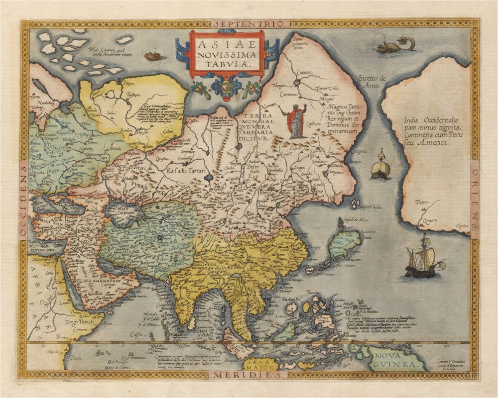
Gerard de Jode
Asiae Novissima Tabula
Certificate of Authentication and Description
This is to certify that the item illustrated and described below is a genuine antique
map, print or book that was first produced and published in 1578, today 448 years ago.
July 31, 2026
Cartographer(s)
Gerard de Jode
First Published
Antwerp, 1578
This edition
1578 first and only edition
Size
34.5 x 44.5 cms
Technique
Stock number
19138
Condition
mint
Description
Excruciatingly rare and important map of Asia, published in the first and only edition of Gerard de Jode's atlas of 1578. In the 1593 edition of his son Cornelis's atlas, the map was replaced by a different map of Asia.
The map is influenced by Gerard Mercator's 1569 wall map of the world, and Giacomo Gastaldi's ca 1561-62 wall map of Asia.
The map is famous for it's early delineation of South East Asia, the Phillipines, the Indian Ocean, the Pacific and northwest America, labelled as a "hardly known part of the West Indies, of the continent of Peru, or America".
Asia and America are separated by Gastaldi's Anian Strait, and a wide open sea route from Europe to the riches of eastern Asia is predicted, the northeastern passage, which would become one of the holy grails of the European quest for the trade with China, Japan and the Spice Islands. The Spice Islands are described with an elaborate text legend in the Pacific.
Condition
Strong paper with very wide margins. No restorations or imperfections. Stunning original color. A supreme example of this legendary map that is lacking in nearly all collections.
Gerard de Jode (c.1509-1591)
Cornelis de Jode (son) (1568-1600)
Gerard de Jode originally issued his atlas in 1578 to compete with Ortelius' atlas with little success. In 1593, two years after his death, Gerard's son Cornelius re-issued the atlas. The success of the atlas was very limited due to heavy competition with Ortelius, who also seems to have bought many copies of de Jode's atlas to take them off the market. Because of this, both editions of the de Jode atlas are exceptionally rare.
"Gerard de Jode, born in Nijmegen, was a cartographer, engraver, printer and publisher in Antwerp, issueing maps from 1555 more or less in the same period as Ortelius. He was never able to offer very serious competition to his more businesslike rival although, ironically, he published Ortelius's famous 8-sheet World Map in 1564. His major atlas, now extremely rare, could not be published until 1578, eight years after the 'Theatrum', Ortelius having obtained a monopoly for that period.
The enlarged re-issue by his son in 1593 is more frequently found. On the death of Cornelis, the copper plates passed to J.B. Vrients (who bought the Ortelius plates about the same time) and apparently no further issue of the atlas was published."
(Moreland & Bannister).
"After the death of Cornelis in 1600, the copper-plates came into the hands of Jan Baptiste Vrients, then the publisher of Ortelius' Theatrum. Apparantly Vrients must have bought them to prevent any further publication of the Speculum."
(Koeman)