Leen Helmink Antique Maps & Atlases
www.helmink.com
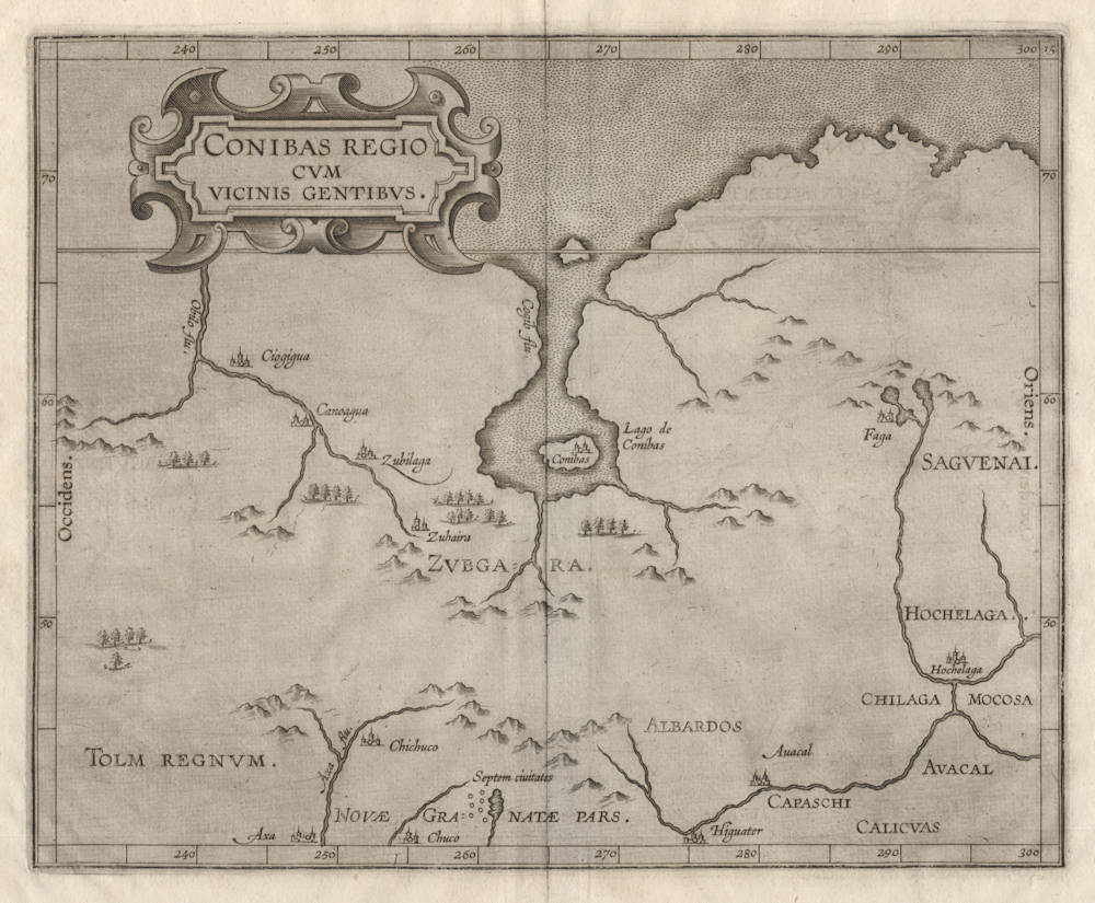
Wytfliet
Conibas Regio cum Vicinis Gentibus
Certificate of Authentication and Description
This is to certify that the item illustrated and described below is a genuine antique
map, print or book that was first produced and published in 1597, today 429 years ago.
June 30, 2026
Cartographer(s)
Wytfliet
First Published
Louvain, 1597
This edition
Douai, 1607
Size
22.8 x 26.9 cms
Technique
Copper plate engraving
Stock number
19095
Condition
mint
Description
Mint example of the first map dedicated to central Canada.
Condition
This is the final state of the map (of three), with the toponym Hignater corrected to Higuater. Blank on verso as in all editions. A strong and even impression of the copperplate. No paper restorations or imperfections. Very wide margins all around. A pristine collector's example of a rare and seminal map.
Summary
The first printed map dedicated to the central regions of present-day Canada and the American Midwest and west.
The map is based on Mercator's 1569 wall map of the world and his 1595 map of the Arctic, combining the early discoveries by Jacques Cartier in the east, and the early Spanish discoveries in the west.
The map was published by Cornelis van Wytfliet in his Descriptionis Ptolemaicae Augmentum, Louvain, J. Bogard, 1597, the first atlas dedicated entirely to the Americas.
The Mapping of North America
"Despite the fact that this map covers territory virtually unknown to the Europeans, it owes its existence to the fact that Wytfliet showed every part of the continent however little knowledge there was of it. This is, however, the first printed map of present-day central Canada.
The basic cartography derives from Gerard Mercator's world map of 1569, which first depicted a large body of water inland in the extreme north. There has been much speculation as to what this might refer to; it has been suggested that it could be a record of a voyage unknown to us that visited Hudson Bay, it could even be remnants of the Verrazano sea theory.
At the top of the map we find the North West passage. On a number of maps at this time various rivers are shown flowing north into these waters; no possible explanation can be given for these other than the assumption that in such a vast expanse of land there would be some. Some sense of the extent of the map can be seen by the incorporation of the 'Septem civitates' [7 cities of gold] of the south-west, and 'Hochelaga', or Montreal, in the east."
(Burden).
Shedding the Veil
The first map of the interior part of Canada. The map shows a lake, island, and city of Conibas, possibly based on sketchy reports of Hudson Bay before Hudson's recorded discovery of it in 1610. Though widely presumed to be fanciful, the fact that three states of the map are known suggests that Wytfliet was grappling with data, rather than creating it. Montreal (Hochelaga) appears in the eastern extreme of the map.
(Suarez).
Cornelis Wytfliet (?-1597)
Little is known of Wytfliet except that he was a native of Brabant, but there is no doubt about the importance of his only atlas, which was the first one printed to deal exclusively with America.
Although its title indicated to be a 'supplement to Ptolemy', Part I covered the history of the discovery of America and its geography and natural history and Part II consisted entirely of the contemporary maps of America and a world map based on Mercator.
(Moreland & Bannister).
Descriptionis Ptolemaicae Augmentum
In 1597 Cornelis van Wytfliet published his Augmentum to Ptolemy's Geography. This is true in as much as it covers all the Americas, a part of the world unknown to the latter; however, no other connection between them exists. Dedicated to Philip III of Spain it is a history of the New World to date, recording its discovery, natural history etc. For the book Wytfliet had engraved nineteen maps, by whom we do not know, one of the world and eighteen regional maps of the Americas. Of these the following eight maps all relate to the north of the continent. As such this book can be truly called the first atlas of America. It was an immediate success and ran to several editions. Not much is known about Wytfliet other than that he was an advocate and secretary to the Council of Brabant, whose capital at the time was Louvain.
Despite the fact that this map covers territory virtually unknown to the Europeans, it owes its existence to the fact that Wytfliet showed every part of the continent however little knowledge there was of it.
(Burden).
THE ATLAS OF AMERICA BY CORNELIS VAN WYTFLIET
The Descriptionis Ptolemaicae Augmentum (“Augmentation to Ptolemy's description”) is the only known work by Cornelis van Wytfliet, secretary to the Council of Brabant, who died in 1597 (a more correct Dutch orthography of his name is “Van Wijtvliet”). He named his work an augmentation to Ptolemy's Geography because it covers the Americas, a part of the world unknown to Ptolemy. However, there is no other connection between the works of Ptolemy and Van Wytfliet.
His book includes 19 maps, a world map and 18 regional maps, all of which were specially engraved for this edition. It was the first separately published atlas with all the maps entirely devoted to America. Most of Van Wytfliet's maps are the first or among the earliest of specific regions of North and South America. The accompanying text describes the geography, natural history and ethnography. It provides a history of exploration and the voyages of Christopher Columbus (1492-1502), John Cabot (1497-98), Sebastian Cabot (1526-28), Francisco Pizarro (1527-35), Giovanni de Verrazzano (1524), Jacques Cartier (1540-42), and Martin Frobisher (1576-78).
Two editions of the Descriptionis Ptolemaicae were published at Leuven in 1597 and 1598 respectively by Jean Bogard and Gerard Rivius. Jean Bogard was publisher in Douai in France (1574-86 and 1598-1616) and Leuven (1586-98; however, it is possible that the Leuven publisher in this period was Jean's son Jean II Bogard). In 1603 the first Douai edition was issued by François Fabri, who continued issuing various editions with Latin and French texts. The last edition of Wytfliet’s book was published in Arnhem, where Jan Jansz. issued an edition with a French text in 1615.
(van der Krogt)