Leen Helmink Antique Maps & Atlases
www.helmink.com
Thévenot
[ untitled ]
Certificate of Authentication and Description
This is to certify that the item illustrated and described below is a genuine antique
map, print or book that was first produced and published in 1664, today 362 years ago.
July 14, 2026
Cartographer(s)
Thévenot
First Published
Paris, 1664
This edition
Paris, 1683
Size
51.0 x 68.5 cms
Technique
Copper plate engraving
Stock number
19090
Condition
mint
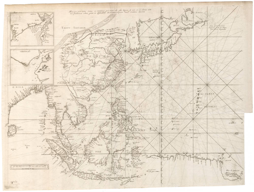
Description
".. the gem of French charts of Southeast Asia."
(Tom Suárez).
Summary
The first and only printed chart of the area which is a faithful copy of a now lost Portuguese portolan chart, in the desirable second state. A pivotal map for collections of the far east.
Condition
State 2 of 2, with mainland Asia filled with details.
Thick and clean paper. No restorations or imperfections. Folded as issued. Strong and dark imprint of the copperplate. Margins all around. A pristine collector's copy of a landmark map of the Far East, by one of the most important cartographers of its day.
Relations de divers voyages curieux
Melchisédec Thévenot's rare sea chart of the eastern part of the Indian Ocean and the Far East, on the same scale and adjacent and contiguous to the companion chart of Eastern Africa and the Middle East. Both charts were copied after now lost Portuguese manuscript charts of 1649 by João Texeira. As such, they are the only printed version of a Portuguese chart of the Indian Ocean and the Far East, covering the navigation route all the way from the Cape of Good Hope in the southwest all the way to Japan in the northeast. They are also the only printed charts with the typical style of Portuguese portolanos, with exaggerated capes and inlets to depict coastlines.
Both charts were first issued in the second part of "Relations de divers voyages curieux, qui n'ont point este publiées, et q'on a traduit ou tiré des Origineaux des Voyageurs Francois, Espagnols, Allemands, Portugais, Anglois, Hollandois, Persans, Arabes & autres Orientaux, données au public par les soins de feu M. Melchisédec Thévenot."
Early Mapping of Southeast Asia
The French chronicler Melchisédech Thévenot published an engraved rendering of a portuguese portolan chart in 1664, which was the very year that the French East India Company was formed. The map appeared in the second part of Thévenot's great compendium of voyages, Relations de divers voyages, a work which was to France what Hakluyt's writing had been to England and Ramusio's had been to Italy. Thévenot, who is believed to have invented the spirit level, based his handsome map on a portolan chart of 1649 by the royal cosmographer of Portugal, João Teixeira. The eighteenth century catographer J.N. Delisle believed that the original chart came into Thévenot's possession after a French ship had pirated it from a Portuguese carrack. Tradition also suggests that the map had actually been published in Lisbon - which would have been a noteworthy event in itself - in 1649, although there is no corroborative evidence for this and no such map is known.
Part of the portolan original are attributed to a Portuguese merchant in Macao by the name of Don João da Gama, who after sailing by a northern route from China to Mexico, reached Acapulco and was promptly arrested by Spanish authorities. Most of the chart, however, probably reflects the Portuguese 'padrão' of the time.
(Tom Suárez).
This sea chart covers the whole area from Ceylon to Japan, including Indonesia, the northern coast of New Guinea, Indochina, Taiwan, the Philippines, China and Japan. The lattitudes cover all the way from 50 degrees North to 10 degrees South. A scalebar is in the southwest, in Portuguese Leguas, with privilege to the King. The Portuguese nomenclature and toponyms have been faithfully copied from the original chart.
The Portuguese stronghold of Malacca (but taken by the Dutch VOC in 1640) is prominenlty depicted, as well as the Portuguese base of Macao, and their trading post in Japan. The map has insets of the Portuguese factory in Bengala near Hoogly at the mouth of the Ganges, and their stronghold further east at Chatigão (now Chittagong in Bangla Desh). Both insets show details of port soundings and safe anchorages. The Chatigão inset shows the 'Casas dos Portugnesos' (sic), with a little Jesuit church, as well as a Chinese pagoda. The mythical Kingdom of Thailand (Siam) is labelled SIÃO.
For China, Thévenot has updated the Portuguese Texeira chart using the Blaeu-Martini Atlas Sinensis, with the Jesuit maps of China, including details of the Great Wall. The details come from from the Blaeu Martini map and the results north of Japan originate from the reconnaissance voyage of Maarten de Vries, as first revealed in the 1652 sea atlas 'Water World' by Jansson. Interestingly, in the far northeast, Thévenot thinly shows the original outline of the Texeira portolan, with the reference to Don João da Gama:
Terra quio Do Ioão
da gama indo, da China
pera Nova Hispanha
[ Lands seen by Dom João
da Gama of the Indies, sailing from China
for New Spain (Mexico) ]
This note refers to what was most probably the first European sighting of the Kurile Islands. In 1589 they used the favorable arcing currents of the North Pacific, illegally sailing from Portuguese Macao to Spanish Acapulco where they were subsequently imprisoned.
Melchisedech Thévenot (1620-1692)
A traveller and author of books on the early voyages of discovery, Thévenot produced some striking charts, perhaps not always his own work but no less interesting because of that. In particular, his map of Australia is the first by a Frenchman, showing the continent with the latest information on Tasman's voyages.
(Moreland and Bannister)
[Tasman] Thévenot, Melchisedech. Relations de Divers Voyages Cvrievx, qui n'ont point esté pvbliées; ov qvi et esté tradvites d'Haclvyt, de Purchas, & d'autres Voyageurs Anglois, Hollandais, Portugais, Allemands, Espagnols; et de quelques Persans, Arabes, et avtres Auteurs Orientaux. Enrichies de Figures de Plantes non décrites, d'Animaux inconnus à l'Europe, & de Cartes Geographiques de Pays dont on n'a point encore donné de Cartes. Première Partie. Paris, Jacques Langlois and Gaspard Meturas, Simon Piget, Emanuel Langlois, Thomas Jolly, and Louys Billaine, 1663.
Thévenot's great collection of voyages was published over three decades from 1663 - 1696. A scholar of prodigious energy, Melchisedech Thévenot assembled his remarkable collection of accounts of the newly explored and newly discovered regions of the world from original manuscript and printed texts, conversations with travellers, and other diverse sources, including accounts of travels in China, Japan, Thailand, Tartary, Mongolia, the Philippines, India, Egypt, Ethiopia, Arabia, Persia, Russia, North, Central and South America, the Pacific, New Guinea, and New Holland. His work grew, with various sections published haphazardly and then cumulated in 1663, 1666, 1672, 1683, and 1696.
Thévenot's Relations is a bibliographically complex work. Effectively there was only one edition, issued in parts over three decades. The first part (the present lot) was published in 1663. Between 1664 and 1683 Thévenot issued further parts and cumulative volumes of the parts already issued. In each case, these subsequent issues included some reprinted sheets, plates, and maps. In its final, posthumous, form the work was issued in 1696 in two volumes. The haphazard nature of publication - with the variously paged parts issued and re-issued, printed and reprinted - means that copies are never entirely identical and often 'incomplete'. Bibliographers have generally avoided detailed descriptions; as Brunet remarks, it is a book of which wil est difficile de trouver des exemplaires complets parce que chaque partie est composé de pièces séparées"; while Sabin declines to collate this or the 1696 edition since "no simple standard arrangement or collation can be given". Brunet notes several variations from copy to copy and the present example accords with his 'ideal description. Of the specific variations he records, the following have been noted in this copy: pp. 7-8 in Terri's voyage are replaced with the map of the Indies as noted "quelquefois” by Brunet; pp. 55-6 in the “Voyage de Bontekoë" are correctly numbered; and, finally, this copy includes at the end the “Routier des Indes Orientales" and the "Privilege” that are not always present.
(Australian Book Auctions, the Davidson Collection Sale, 2005)