Leen Helmink Antique Maps & Atlases
www.helmink.com
Plancius
INSULAE MOLUCCAE celeberrimæ sunt ob Maximam aromatum copiam quam per totum ...
Certificate of Authentication and Description
This is to certify that the item illustrated and described below is a genuine antique
map, print or book that was first produced and published in 1592, today 434 years ago.
July 4, 2026
Cartographer(s)
Plancius
First Published
Amsterdam, 1592
This edition
1617 third and final state
Size
39.0 x 55.5 cms
Technique
Copper engraving
Stock number
19080
Condition
pristine
Description
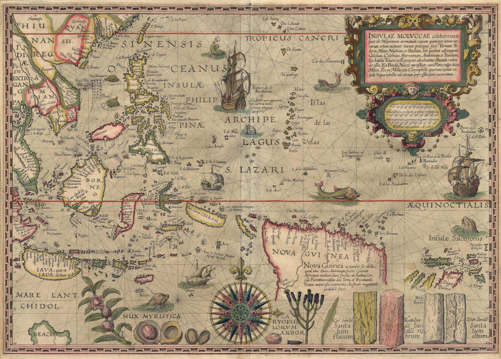
Petrus Plancius' legendary map of the Spice Islands
The campaign map that promoted the funding of the first Dutch expedition to the East Indies leading to the founding of the VOC.
FINAL STATE, of exceptional rarity. Only eleven copies known, nearly all in institutions.
The most famous, most important, most beautiful, most desirable and rarest of all Far East maps, the Spice Map designed by Petrus Plancius. First issued between 1592-94 by Cornelis Claesz, this is the third and final state of 1617, identical to the first and second state but here with the imprint of Claes Janszoon Visscher. This original Plancius copperplate is not to be confused with the relatively common English pirate copy of 1598 by John Wolfe, which was included in the English edition of Linschoten's Itinerario.
Condition
Here in the final state of 1617, with the copperplate unchamged, but signed “CJ Visscher excudebat Anno 1617”.
A dark and even impression of the copperplate. No restorations or imperfections. Verso blank as always. Attractive original colour. Pristine collector's condition.
Rarity
Schilder (2003) lists five copies of the first state, five of the second state, and eleven recorded examples of this final third state.
Summary
A spectacular and highly decorative chart of the East Indies, arguably the most famous early map of the region. Due to its extreme rarity and its splendour, the map is mythical.
The map was designed by Petrus Plancius, engraved by Johannes van Doetecum and sold as a separate chart by Cornelis Claesz’ publishing house. It is richly decorated with compass rose, ships and sea monster, as well as with depictions of spices (nutmeg, cloves, and sandal-wood), hence the nickname “spice map”. This propaganda map inspired the Dutch and the English to send fleets to Asia for direct trading.
The van Doetecum brothers were from a family of engravers and map publishers working in Deventer and Haarlem from 1587. They engraved maps for Plantijn, de Jode, Waghenaer, Ortelius, Barentsz, Hondius and Linschoten. Baptista van Doetecum also engraved Petrus Plancius’ famous wall map of the world of 1592. Like Plancius 1592 wall map of the world, this map here is based on Portuguese and Spanish sources, which can also be seen from the geographic nomenclature. The two countries were one united kingdom at the time. During an intelligence visit to Lisbon, Cornelis de Houtman had succeeded to secretly buy a set of manuscript charts from Bartholomeo de Lasso. These maps enabled the fast Dutch expansion overseas. Some maps were used also for Jan Huyghen van Linschoten’s famous Itinerario.
This map gives a good insight in the Portuguese cartographical achievements at a time when for reasons of secrecy such information was not permitted to be distributed or printed in the Iberian peninsula.
The map shows the Spice Islands at a detail never seen before. The map is of utmost importance to Australia. In the lower left is “Beach”, a legendary kingdom south of Java, described by Marco Polo who traveled to China in the late 13th Century. It is modeled after Mercator’s 1569 wall map of the world, as part of “Terra Australis”. For New Guinea and below, there is no doubt that Willem Jansz(oon) used this chart on his 1606 voyage leading to the first discovery of Australia.
The map was issued and sold as a loose separate sea chart by the Cornelis Claesz, the most important publisher of his day and a great drive for the Dutch maritime exploration and expansion. About twenty copies of this map are known in three states (5 of the first state, 5 of the second state, and 11 of the third state), nearly all in library and museum collections.
Title Cartouche:
INSULAE MOLUCCAE celeberrimæ /
sunt ob Maximam aromatum copiam quam per totum ter- /
rarum orbem mittunt: harum praecipuæ sunt Ternate, Ti- /
doris, Motir, Machian & Bachian, his quidam adjungunt /
Gilolum, Celebiam, Borneonem, Amboinum & Bandam. /
Ex Insula Timore in Europam advehuntur Santala rubea /
et alba, Ex Banda nuces myrysticæ, cum Flore, vulgo dicto, /
Macis, Et ex Moluccis Caryophilly : quorem icones in pe- /
de hujus tabellæ ad vivum expressas poni curavimus.
'The islands of the Moluccas are very famous because of
their extremely great wealth in spices, which they export
over the whole world. The most important islands are
Ternate, Tidor, Motir, Machian, and Bachian. Some would
expand this list to include: Gilolo, Celebes, Borneo,
Ambon, and Banda. From the island of Timor, red and
white sandalwood is shipped to Europe, from Banda nuts
with their flowers commonly named mace, and from the
Moluccas clove tree. At the foot of this map, we have
arranged to include pictures of these products drawn
from nature'.
Text in New Guinea:
Nova Guinea a nautis sic dicta, /
Quod eius litora, locorumque facies Guineæ /
Africanæ multum sunt similia. Ab Andrea Cor- /
Sali Florentino videtur dici Terra de Piccinacoli. /
Partem autem eße continentis Australis magnitudo /
Probabile facit.
'New Guinea is called such by the seafarers because its
coasts and the view of its places strongly resemble those
of African Guinea. The Florentine Andrea Corsali seems to
call it the Land of the Piccinacoli [Dwarfs].
Its size makes it probable that it forms part of the
southern Continent [Continentis Australis]'
Text east of Ceram:
Hic hybernavit Georgius /
de Menezes
'Jorge de Menezes wintered here'.
Jorge de Menezes was a Portuguese explorer who in 1526-27 landed on Waigeo Island, taking shelter whilst he awaited the passing of the monsoon season. He named the region Ilhas dos Papuas and is thus credited with the European discovery of Papua. He was the Portuguese Governor of Ternate (which was first visited by the Portuguese as early as 1512).
Wieder, Monumenta Cartographica Vol II, 1926:
In 1592 a privilege was given not only for a world-map, but for 14 special navigation charts. There are no maps of this kind known bearing Plancius’ name, but certain charts engraved by the Van Doetecoms have been recognized as belonging to that set of 14. In all there are now probably 11 maps known which may have belonged to that set of 14. The study of early Portuguese and Spanish cartography is not yet so far advanced that we can describe with any certainty the development of the official Spanish world-map, the ‘padron real’, or decide from what sources the maps privately made were derived, and whether their authors had access to the ‘padron real’ or not.
Wieder on this particular map:
(1592). Molucca Islands (by Plancius).
The first state was mentioned for the first time, and hesitatingly brought into relation with Plancius, by myself in the Catalogue of the Koloniaal-aardrijkskundige Tentoonstelling, Amsterdam 20 Sept - 31 Oct. 1913. No. 351.
Günter Schilder, Monumenta Cartographica Vol I, 1980:
In the privilege that Cornelis Claeszoon received in 1592 from the States General, he obtained permission
‘to print or draw with the pen all of the twenty-five special charts as received by the direction of Mr. Peter Plancius, but charged to him by Bartholomeo de Lasso, cosmographer and maestro of navigation for the King of Spain, containing all the sea-coasts of the whole earth’.
Whether Cornelis Claesz. effectively published all twenty-five charts mentioned in this privilege is something we do not know. At this moment I am confining myself to refer to the description given by F.C. Wieder in volume two of his Monumenta Cartographica, op. cit. pp. 37-38 (nos. 15-34). It is the intention to publish full-size reproductions of this set of charts in one of my forthcoming volumes of Monumenta Cartopgraphica Neerlandica [Vol VII, 2003]. One thing, however, is certain, the charts published since 1592 by him are the oldest Dutch charts showing non-European coastlines. Due to the fact perhaps, that the basic knowledge of these charts came from Portuguese and Spanish sources, they constituted a stimulant for the improvement of Dutch chart-making. All charts belonging to this series were engraved by the Van Doetecum family. By their characteristic and splendid engraving technique, the charts engraved by the van Doetecum family belong to the best examples of Dutch cartography of that period.
Günter Schilder, personal communication:
By today, this chart and the others mentioned by Wieder have been definitely identified as the Plancius' maps mentioned in the privilege, by means of a catalogue of Cornelis Claesz, found in the Wolfenbüttel collection, Claesz lists all the copperplates that he has and attributes the maps in question to Petrus Plancius.
Günter Schilder, Monumenta Cartographica Vol VII, 2003:
This improved knowledge found its way into Europe by way of Portuguese maps, among other means by its inclusion on printed maps, of which the Plancius map must be considered one of the earliest. This dependency on Portuguese sources is evident for the entire map when we compare the drawing and the toponyms with those on the manuscript maps of Bartolomeu Lasso dating from 1590.
As noted in the title, running along the lower edge of the map are drawings of the most coveted products of the Moluccas:
• Nux Myristica
'Nutmeg'
• Caryophilorum Arbor
'Cloves'
• Santalum flauum / Geel Sandel
'Yellow sandalwood'
• Santalum rubrum / Root Sandel
'Red sandalwood'
• Santalum album / Witt Sandel
'White sandalwood'
These pictures were intended as publicity for the distant voyages to be undertaken by the Dutch merchants; they were included as an incentive in attracting capital to finance these ventures.
LITERATURE
Moes-Burger IV, VI, 1900-1915.
Wieder, Monumenta Cartographica Neerlandica, Vol II, 1926.
Tooley and Bricker, Landmarks of Mapmaking, pp 122, 1968.
Günter Schilder, Monumenta Cartographica Neerlandica, Vol I, Canaletto, 1980.
Günter Schilder, Monumenta Cartographica Neerlandica, Vol VII, Canaletto, 2003.
Günter Schilder personal communication.
Robert Putman, Early Sea Charts, pp 113, 1983.
Thomas Suárez, Early Mapping of South East Asia, pp 174, 1999.
Martin Woods, Mapping our World, Terra Incognita to Australia, pp 104, on the English pirate version, National Library of Australia, Canberra, 2013.
Petrus Plancius (1552-1622)
Born as Peter Platevoet in Flanders, Petrus Plancius studied abroad and became a theologian and a mapmaker.
He produced some globes and maps, including a well-known world map in 1592. He had a great influence on the Dutch Asian expeditions.
Early Years
Peter Platevoet was born in 1552 in the Flanders village of Dranouter. Little is known about his childhood, but it seems that his parents became Protestants. Platevoet studied theology, history, and languages in Germany and England. In England he probably learned about mathematics, astronomy, and geography. When he was older, Platevoet Latinized his name, as was the custom among savants at that time.
In 1576 he became a preacher in West-Flanders, a province in Belgium, and later that year he went to Mechelen, Brussels, and Louvain. In the 1580s he stayed in Brussels for a long time, but when the city surrendered to the duke of Parma, King Philip II of Spain’s governor-general in the Netherlands, in 1585 Petrus Plancius fled to the north. He lived in Amsterdam and became a pastor of the Dutch Reformed Church. From December 1585 until his death on 15 May 1622, he fulfilled his job as preacher. Plancius was a fervent Contra-Remonstrant and discussed many theological issues.
In addition to his thorough knowledge of the Holy Bible, he was well-grounded in the study of cosmography, geography, and cartography. He was not only one of the most talked-about preachers in the Dutch republic, but also one of the important mapmakers of his time.
Early Publications
Petrus Plancius was the first caert-snyder (map cutter) in the Dutch republic to produce waxed grid maps. Therefore, on 12 September 1594 he received a patent for the publication and distribution of the world map for twelve years from the States-General. He was, together with the Flemish engraver and map-maker Jodocus Hondius and the brothers Van Langren, one of the first makers of celestial globes in the Netherlands. His first globe was produced in 1589, a revision of an earlier celestial globe. Among his revisions were four additions to the southern sky: the two Magellanic Clouds (they were unnamed on the globe) and two new constellations, Crux and Triangulus Antarticus. Their positions were taken from reports of explorers.
In 1590 Petrus Plancius made five terrestrial maps for a Dutch edition of the Holy Bible. Two years later he made a well-known world map: Nova et exacta terrarum orbis tabula geographica ac hydrographica (New and exact geographical and hydrographical map of the world). This map contained celestial planispheres in the upper corners on which he added two additional constellations.
Asian Expeditions
Petrus Plancius was one of the driving forces behind the first Dutch expeditions to Asia, assisting with preparations and providing instruction. To avoid encounters with Spain and Portugal, which were already sailing to the East Indies around southern Africa, Plancius decided to try a northeast route around Asia. He supplied maps for the voyage and advised the fleet commander, Willem Barents, in celestial navigation. The northeast voyages of 1594 and 1595 were failures, but a third attempt was made in 1596. It was on that last expedition that Barents’s ship got stuck in the polar ice, and the crew had to spend the winter in Nova Zembla, an island northwest above Russia, in what came to be called the Barents Sea. Late in the spring of the next year, the crew was able to sail south in two small boats. Barents died on the return voyage; the survivors arrived at Amsterdam in November 1597, not having found a northeast passageway.
In 1595, together with Barents, Plancius published a book titled Nieuwe Beschrijvinghe ende Caertboeck van de Middelandtsche Zee (New description and map book of the Mediterranean Sea). In this work he designed a map that was engraved by the well-known globe- and map-maker Hondius.
Because the northeast sea route around Asia did not seem very promising, even before the third voyage a group of Dutch merchants had financed a southern expedition. Plancius again helped with the planning and used the opportunity to conduct scientific research. A theory in the late sixteenth century claimed that a compass needle’s variation from north (its declination) would enable one to determine longitude. Plancius developed his own theory to ascertain longitude at sea by means of magnetic variation. To test that theory during the southern voyage, Plancius taught junior merchant Frederik de Houtman how to measure and record compass declinations. It is known that the method developed by Plancius was used from 1596 onward by mariners.
Plancius also used the voyage to discover southern stars that were not visible from Europe. He taught navigators, especially Pieter Dircksz Keyser, but also other sailors, how to measure star positions with an astrolabe and instructed them to chart the southern sky. From ship records of 1596 it is known that the astrolabe was used to measure the declination of the southern stars.
The Dutch southern expedition, known as the Eerste Shipvaart, or First Voyage, set sail from the port of Texel in April 1595. It reached the East Indies in 1596 and returned to Texel in August 1597. Plancius asked Keyser, the chief pilot on the Hollandia, to make observations to fill in the blank area around the south celestial pole on European maps of the southern sky. Keyser died in Java the following year, but his catalog included 135 new stars arranged in twelve new constellations. Most of them were invented to honor discoveries by sixteenth-century explorers. They were first published on a 1598 celestial globe made by Hondius.
After the foundation of the VOC (Verenigde Oostindische Compagnie, or East India Company) in 1602, Plancius became its first mapmaker. During the first quarter of the seventeenth century, he seemed more interested in preaching than in cartography and cosmography. But still, some of his maps were published during that time. In 1607 he produced a large revised world map. In 1612 he created a celestial globe, and later he designed an Earth and another celestial globe (1614 and 1615), both brought out by the well-known publisher Petrus Kaerius. His contemporaries described him as one of the greatest geographers of his time.
Bibliography
A complete bibliography of Plancius’s work, with descriptions of much of his maps and publications, is Günter Schilder, Monumenta Cartographica Neerlandica, Vol. VII, Cornelis Claesz (c. 1551–1609): Stimulator and Driving Force of Dutch Cartography, Alphen aan den Rijn, Netherlands: Canaletto/Repro-Holland, 2003.
(encyclopedia.com)