Leen Helmink Antique Maps & Atlases
www.helmink.com
Michiel Coignet
Nieuwe onderwysinghe op de principalste puncten der Zee-vaert / De Zeevaert ...
Certificate of Authentication and Description
This is to certify that the item illustrated and described below is a genuine antique
map, print or book that was first produced and published in 1580, today 446 years ago.
July 26, 2026
Cartographer(s)
Michiel Coignet
First Published
Antwerp, 1580
This edition
Amsterdam, 1598
Size
cms
Technique
Copper engraving
Stock number
19032
Condition
pristine
Description
Enter the Dutch
The Coignet was on board of all early Dutch ocean crossings to all corners of the world, to the East, to the West, circumnavigating the globe and on Arctic travels.
Two pilot guides (Medina and Coignet) in one binding, as published and sold at the time
Medina, P. de. De Zeevaert oft conste van ter Zee te varen, vanden excelenten Pilote Meester Peeter de Medina Spaegniaert.
Coignet, M. Nieuwe Onderwijsinghe, op de principaelste puncten der Navigatien.
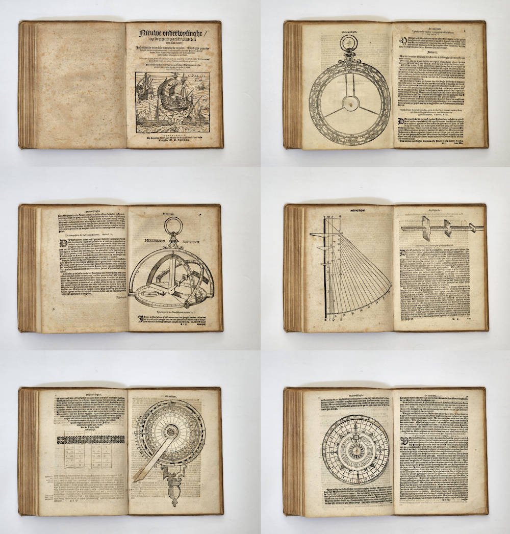
Amsterdam, Cornelis Claesz., 1598, 3rd edition, 2 parts in 1 vol, 84,(3); (2),22,(3) leaves, numerous woodcut illustrations, including four volvelles with revolving parts and diagrams, original contemporary velllum binding. On leaf 14r a small circular world map encircled by eight cherubic wind heads (Shirley 84). This map is repeated in slightly different form on leaf 79v.
FIRST DUTCH GUIDE ON THE ART OF NAVIGATION
Coignet's Dutch translation of Pedro de Medina's Arte de Navegar, issued in combination with his own practical navigation guide, was the first great book in Dutch on the art of navigation and was consequently an enormous stimulus to Dutch seamanship.
The first Spanish edition of Pedro de Medina was printed in 1545 and was followed by numerous later editions and translations into French (1554), Italian (1554), Dutch (1580) and English (1581). The Dutch edition is of highest significance as containing the important treatise of Michel Coignet.
(Nico Israel, Catalogue 22, 1980)
Background
Pedro de Medina's Arte de Navegar (the Art of Navigation) (Sevilla, 1545) was the first and only pilot guide of the 16th century on ocean crossing navigation, at a time when all other pilot guides were written for coastal navigation in European waters. The 1545 first edition is considered unobtainable and of high value. The book was translated in French, Italian, Dutch and English. Medina's Art of Navigation was instrumental for the early European age of exploration.
In 1580, Michiel Coignet of Antwerp translated Pedro de Medina's pilot guide in Dutch and issued it in combination with his own new pilot guide Nieuwe onderwysinghe op de principaelste puncten der Zee=vaert (New teachings on the principals of Navigation).
As Schilder writes:
"Coignet's contribution was even more practical than that of De Medina, and the ordinary seaman found it clearer and easier to understand. Coignet's Nieuwe onderwysinghe treats the practice of navigation in more depth. It also presents a clear discussion of the principles of navigation, the winds, sea charts, and determining one's position at sea. Furthermore, it gives an extensive description of the current instruments of navigation such as the astrolabe, cross-staff, and the noctolabe. The contribution by Coignet increased the value of De Medina's book considerably".
Noteworthy is that Coignet even gives details on how to construct accurate navigation tools.
The Coignet/Medina pilot guide for ocean navigation was a book of utmost importance. Multiple copies for the pilots and the captain were on board of all early Dutch fleets crossing the oceans and circumnavigating the globe. The book was first issued in 1580 and re-issued three times, in 1589, 1592 and 1598.
From around 1595, the Dutch commanders and pilots of the pre-VOC companies were thoroughly educated by Petrus Plancius in long-range navigation on the high seas, based on knowledge from Iberian sources. He played a big role in the education and training of officers for the Amsterdam expeditions to the Far East. The directors of these pre-companies richly rewarded him for his services.
The navigators and skippers were trained using Coignet's new navigation guide, that was bound with his Dutch translation of the Medina.
Plancius had great involvement in the training and examining of the steersmen of the first Dutch Fleet to the Indies of 1595-97, and for this fleet specifically trained Frederick de Houtman and Pieter de Keyser to map and name the unrecorded celestial constellations on the southern hemisphere, many of these still bear the names that de Keyser and de Houtman gave to them.
He was also involved, together with Robert Robertsz le Canu, in the navigational training and route planning of the three Amsterdam polar expeditions commanded by Barentsz that sought to find a northeastern passage to the Far East.
The wooden lodge where Barentsz crew wintered at Novaya Zemlaya in 1596-97 in their attempts to reach China and the Spice Islands via a northeast passage, was rediscovered in 1871, almost 400 years after their epic efforts. Many artefacts were excavated, one of the most famous of which was a frozen copy of Coignet's navigation guide, now one of the exploration treasures of Amsterdam Rijksmuseum.
This was the first time that an arctic winter was successfully faced. The voyage stands in the first rank among the polar enterprises of the 16th century, and led to a flourishing whale and seal fisheries which long enriched the Netherlands.
Rarity
Exceptionally rare navigation guide of which only a handful of examples have survived. Lacking in all collections.
Despite the high demand for the Coignet/Medina pilot guide, the book is impossible to find, because it was a practical tool used and worn out on board of ships, not a book for armchair travelers. The book is so rare that it until 1975 no copies of this pilot guide was in any the Dutch Maritime Museums. Among the few surviving copies of the first edition is the one kept in the Rijksmuseum in Amsterdam. It was left on the island of Novaya Zemlaya in 1597 after the succesful wintering of Willem Barentsz and his men and was recovered, badly damaged, by the Norwegian captain Ellis Carlson in 1871.
Condition
First part quires F and G misbound before quire E; minimally browned/ foxed; partly with water stains in lower margin. Very fine condition. Original contemporary vellum binding. A near flawless copy, no restorations or imperfections, complete with all of the requisite volvelles in pristine working order.
Content of the First Book (Pedro de Medina - "The Art of Navigation")
-01 On the world and the celestial bodies in the universe
-02 On the seas and the oceans
-03 On the winds, their names, directions and how to sail them
-04 On the declination of the Sun and how to use it
-05 On the declination of the (north and south) poles and how to use them
-06 On the directions of the compass
-07 On the trajectory of the Moon and the tides of the Sea
-08 On the days of the Year, and the various sunrises and sunsets
Content of the Second Book (Michiel Coignet - "New teachings on the principles of Navigation")
-01 On the essential principles of navigation
-02 On the Winds
-03 On the magnetic Compass
-04 On Sea charts and their proper use
-05 How to determine latitude every midday using the declination of the Sun
-06 How to constuct an astrolabium to determine the declination (latitude)
-07 How to use the described astrolabium
-08 To determine latitude at any time of day using a new instrument (hemispherical astrolabium/half sea sphere invented by Coignet)
-09 How to contruct this half sea-sphere
-10 How to use this half sea sphere
-11 To determine latitude at night
-12 How to contruct the cross-staff (Jacob's staff) for determining angles
-13 How to use the cross-staff
-14 On a new instrument to observe the movements of the Pole Star and its companions (dipper)
-15 How to determine the time of night with the aforesaid instrument
-16 On the stars around the Southern Pole (Southern Cross)
-17 How many miles to count in a degree, depending on the sailing direction
-18 The mistake introduced by sailing outside the compass direction used
-19 On the tides
-20 The way to sail (due) East and West, clarified by rules and examples
The first manual to make a clear distinction between Pilotage, Navigation and Cosmography
In the first chapter Coignet explains that navigation is divided into the "Ghemeyne zeevaringhe" [common navigation] -- navigating when land or navigational marks are in sight -- and the "groote zeevaringhe," [grand navigation] when astronomical instruments are being used.
Books on the art of navigation and cosmography, published by Cornelis Claesz
Around 1580, at the start of the great voyages that were to bring the first Dutch ships to the East and West Indies by the end of the sixteenth century, navigation took new pathways in its development. To sail on the open ocean, Dutch navigators had to have much greater skills than they had needed to sail along the European coasts. Now, they had to leave the familiar coastlines and venture out into unknown waters. Seeking guidance, Dutch seafarers naturally looked for mentors in Spain and Portugal. These two countries already had a long history of sailing the world's seas; they had built up sailing experience and had given the art of navigation a scientific basis. The knowledge that was locked up in foreign-language books suddenly took on a much greater relevance for Dutch navigation. The arsenal of information that existed in the Netherlands was greatly expanded when translations appeared of well-known reference works and textbooks from countries where navigational techniques were already more advanced. Besides the Iberian Peninsula, this also included England, where the art of navigation had reached new heights. It is not surprising that Cornelis Claesz seized the opportunity; he made sure that the pertinent publications also came out in Dutch editions.
Pedro de Medina and his Arte de navegar
Learned astronomers and geographers established working relations with men whose knowledge was drawn from experience. The problems these seamen had encountered in the course of their travels were unknown in coastal navigation. The success of such collaboration on the Iberian Peninsula led to the publication of important standard works on the art of navigation. Thanks to Pedro de Medina (1493-1567), developments in the technique of navigation could spread throughout much of Europe. His Arte de navegar, the most important manual in the field, was published in 1545 in Valladolid. No later editions of this work appeared in Spain itself. Nonetheless, the numerous editions in other languages – French (14), Italian (3), Dutch (4), and English (2) – gave this work its great importance for the advancement and proliferation of techniques of navigation.
The earliest Dutch edition, entitled De Zeevaert Oft Conste van ter Zee te varen, appeared in Antwerp in 1580. It was published by Hendrick Hendricksen in a translation by Maarten Everaert of Bruges. It was this edition that Willem Barentsz and Jacob van Heemskerck took along on the third polar expedition of 1596. It was this same Antwerp edition that they left behind after their famous winter on Novaya Zemlya. Nearly three hundred years later it was found there ([frozen in ice] now in the Rijksmuseum collection). The Dutch version of De Medina's work included a contribution by an adept in mathematics and navigation, namely Michiel Coignet (1549-1628) of Antwerp. Coignet's contribution was even more practical than that of De Medina, and the ordinary seaman found it clearer and easier to understand.
Later copies of this compilation were published in Amsterdam by Cornelis Claesz in 1589, 1592, and 1598. The Amsterdam and Antwerp editions were identical in content, except for the fact that the dedications (by the translator Everaert to Archduke Matthias of Austria, the other by Coignet to the Antwerp merchant Gillis Hooftman) were left out in the later three editions. New woodblocks were cut for the illustrations based on examples from the Antwerp edition. The title of the earliest edition published by Cornelis Claesz reads as follows:
De Zee=vaert oft Conste | van ter Zee te varen, vanden Excellenten Pilote Meester Peeter de Medina | Spaignaert.
Inde welcke niet alleene de Regels, Secreten, practijcken, en | constighe Instrumenten der seluer Consten begrepen zijn: Maer oock de | clare ende oprechte fondamenten der
Astronomijen, ende gantschen | loop des Hemels, op d'alder lichste ende duyde= |lijcxste verclaert worden.
Allen Cooplieden, Piloten, Schippers, ende anderen Liefhebbers der Astrono- | mijen tot nut en dienst: Wt den Spaensche ende Françoysche in onse Ne- | derduytsche tale ouergheset, ende met Annotatien ver- | ciert, by M. Merten Eueraert Brug.
Met noch een ander nieuwe onderwijsinghe, op de principaelste puncten | der Nauigatien, van Michiel Coignet.
T'AMSTELREDAM, | By Cornelis Claesz. opt Water, int Schrijfboeck, by deie oude | Brugghe. M.D.LXXXIX.
Michiel Coignet's contribution follows suit to Medina's work; it is also supplied with Cornelis Claesz's imprint:
Nieuwe onderwysinghe, | op de principaelste puncten | der Zee=vaert. Inhoudende
diversche nootelijcke regulen, constighe practijc= | ken, en sonderlinghe bequame
Instrumenten, die alle Piloten, Stier= | lieden, ende andere, die daghelijcx de Zee
hanteren, | vastelijcken behooren te verstaen.
Item een lichte, maer sekere ende perfecte maniere, om oost en West te varen, |
d'welck tot noch toe allen Piloten onbekent is gheweest.
Nu nieuwelijcken eerst (wt de conste van Mathematica) ghe- | practiseert, ende by een
vergadert, deur | Michiel Coignet.
T'AMSTELREDAM, | By Cornelis Claesz. opt Water, int Schrijfboeck, by d'oude |
Brugghe. M.D.LXXXIX.
Apparently, the work of De Medina and Coignet was in great demand, because Cornelis Claesz published new editions in 1592 and 1598.
Thanks to the translation of De Medina's book, Dutch seafarers could learn about subjects with which they were supposed to be acquainted: the interpretation and use of the sea chart; the technique of calculating the latitude of their position by measuring the elevation of the sun and the Polar Star; familiarity with the compass; calculation of the phases of the moon and the tides; determination of the time at night from the position of the stars.
Coignet's Nieuwe onderwysinghe treats the practice of navigation in more depth. It also presents a clear discussion of the principles of navigation, the winds, sea charts, and determining one's position at sea. Furthermore, it gives an extensive description of the current instruments of navigation such as the astrolabe, cross-staff, and the noctolabe. The contribution by Coignet increased the value of De Medina's book considerably.
(Günter Schilder Monumenta Cartographica VII)
Nico Israel, Ernst Crone and Pedro de Medina's
De Zeevaert oft Conste van ter Zee te varen
Having been asked to contribute to this Liber Amicorum of Nico Israel, I checked to see how many items were acquired from Nico Israel over the years by the Nederlands Scheepvaart Museum in Amsterdam. I discovered that the total outnumbers a hundred and consists of books, manuscripts, charts, maps and a single instrument. As the diversity of these acquisitions will not allow for a homogeneous contribution, I decided to pick out one object, a book, of which I know that Nico Israel has special memories. The book in question did not come to the Museum directly from Nico Israel, but as part of the library of the late Dr Ernst Crone, which was left to the Museum in 1975.
One of the most famous collections of early pilot guides and navigational instruments was put together over many years by Dr Ernst Crone (1891-1975) from Amsterdam. His collection, the Crone Library, is now part of the Scheepvaart Museum in Amsterdam (Maritime Museum). Ernst Crone became one of the main benefactors of the Scheepvaart Museum in Amsterdam. From 1927 onwards he was a Trustee and from 1938-67 he was Chairman of the Board of Trustees. His position as a Trustee could have given cause for conflict with his private collectorship. Rather than allowing this to happen, an agreement was made between Crone and the Museum. Whenever an important navigational manual were to turn up, which both Crone and the Museum wanted for their libraries, a consultation was to take place between the collector and the Director of the Museum. Often Crone would be the buyer as the Museum was then an unsubsidised private institution. The little money available for acquisition had to be spent with great care. It was also agreed that the Museum would not buy books already present in the Crone Library. When, eventually, the two libraries would come to be united, and there was no doubt that one day this would happen, a large library on the history of navigation would result. The merger was effected after the death of Ernst Crone when, with the help of Nico Israel, the Crone Library was sorted and valued before being transferred to the Museum.
The books of which Crone was proudest were those by Pedro de Medina. The Arte de Navegar has been of great importance for spreading the art of navigation in Europe. It was translated into French, Italian, English and Dutch.
In Crone's memoirs he explains how he acquired his first Coignet/Medina copy. In 1926 the library of Jonkheer J.W. Six van Vromade was to be auctioned in The Hague. Among the books was a 1598 edition of the book [same edition as the one on offer here]. Crone was determined to buy it but was informed by the Director of the Scheepvaart Museum W. Voorbeijtel Cannenburg that W.A. Engelbrecht in Rotterdam was also bent on getting that book. Engelbrecht became an important benefactor of the Maritiem Museum 'Prins Hendrik' in Rotterdam when, after his death, his large and important collection of charts, atlases and navigational manuals was left to that Museum. Although both he and Crone collected in the same field, they rarely crossed swords. The opportunity to buy a Dutch De Medina was such a rare occasion. Crone learned that Engelbrecht was prepared to pay no less than f 1,400 for the book, then a large sum of money. With this Engelbrecht hoped to outprice Crone. The latter, however, wanted to avoid a confrontation in the auction room which would almost certainly have led to a fancy price. Through the intermediary of Voorbeijtel Cannenburg he proposed to Engelbrecht that they should buy the book jointly and then present it to the Scheepvaart Museum where there was no copy of this book. Engelbrecht agreed and the book was bought by Voorbeijtel Cannenburg at the auction for f 140, only ten percent of the sum Engelbrecht had been prepared to spend. Many years later another copy of the 1598 edition came on the market. Crone, still without a Dutch De Medina, offered Engelbrecht half of f 140 for the right to buy this copy. Engelbrecht agreed and, at last, Crone became the owner of a Dutch De Medina.
(Willem Mörzer Bruyns, former curator of Amsterdam Maritime Museum)
Sailing School
The Iberian ventures into the New World and into the Indian Ocean quickly and profoundly changed the nautical techniques that were required to safely perform the profitable transoceanic enterprises. It required skilled pilots that mastered the new mathematized celestial navigation. This "large", blue-water navigation forced mariners to not look to the coast to orient the vessel but skyward. The questions remained the same; What was the ship's location, and how could it best reach port safely. However, further out to sea it was no longer possible to identify one's position by observing familiar landmarks or by testing the ocean floor for depth or composition (sand of specific colour, shells, mud, rocks, and so on).
In 1508, Ferdinand II appointed Amerigo Vespucci as Spain's first inaugural piloto major, charging him with examining the pilots who sailed to the Americas and with approving their maps, instruments, and rutters. Sailors had to make independent arrangements for private classes to prepare for these exams, until in 1552 the Casa de Contratación (the "House of Trade" in Seville) established a formal navigation school, chaired by a cosmographer. In the centuries ahead, it would serve as a model for maritime communities accross Europe.
The teaching was done by university-trained instructors appointed by the king, who were expected to replicate the book-bound systems with which they were familiar, in this way eliminating the limitaions and flaws of oral communication that had aided the mariners in the centuries past. As an example, the instructors were required to teach the astronomy books by Petrus Apianus and Gemma Frisius, but also the first two chapters of Johannes de Sacrobosco's De Sphaera, the standard introduction to the Aristotelian structure of the heavens that defined and explained the mutual relationship between the celestial bodies as well as their relationship to a moving vessel far below.
Our students found themselves in a classrooms with a group of fifteen or so others, listening to twice-daily lectures straight out of a university textbook. This textual, classroom-based approach was a perplexing strategy for teaching men who were in all likelyhood not literate, who had until then effectively acquired their professional skills aboard a hip under the tutelage of more senior mariners, and who were accustomed to learning with eye and hand as well as with ear.
The most important book of all was Pedro de Medina's Arte de Navegar ("The Art of Navigation"), the first comprehensive guide for ocean navigation, that combined cosmography with the techniques and instruments of practical navigation. It was profusely illustrated with endless examples, illustrations, diagrams, volvelles and detailed chapters on the heavens, the seas, the winds, the height of the Sun, the poles, and the magnetic compass. The final two chapters treat the Moon and the days of the year and their relationship to the tides. This approach - defining the components of the universe in descending order from the grandeur of the spheres down to intervals of days and minutes - is a key trait of the "cosmographical" nautical manual.The work also includes astronomical tables - the "regiments" of the Sun and stars - that enabled mariners to determine latitude by measuring the altitude of these celestial bodies.
The Arte de Navegar was first published in 1545 in Valladolid. It was dedicated to the future Philip II, in support of Medina's quest to be appointed royal cosmographer. This work was an overview of existing knowledge on this subject, and was in a sense a revision and expansion of his "Book of Cosmography" of 1538, which had already been examined by the Council of the Indies. Arte was the first treatise on celestial navigation, and would soon be followed by a book by Martín Cortés de Albacar (son of Hernando Cortes and ....), published in Cádiz in 1551. Pedro de Medina had already served the crown as a consultant on maritime matters and taught in Cadiz from 1530 on. In his dedication to Philip II, he conjured up a concerning vision of mariners on "long dangerous voyages" where few of them knew the necessities of navigation because "there were no teachers to teach them, nor books to read". His work would set the standard for navigational textbooks for years to come.
The transmission of the Arte from Spain to the Low Countries went by way of Antwerp, where Michiel Coignet published a Flemish translation of Medina in 1580. Coignet, whose own important work was published as an appendix to his translation of Medina's Arte, explained that "large navigation" not only required all common practices of coastal navigation, but also "many other diverse and ingenious rules and instruments taken from the arts of Astronomy and Cosmography." In his work, we see two different models in play: the academic framework of the Spanish tradition juxtaposed against the more practical, enrepreneurial Dutch usage, the one beginning with cosmographical definitions, the othe with pragmatic calendrical data. Coignet, an engineer and wine gauger, brought different interpretive skills to the same material, choosing different things to illustrate, striving to elucidate complex material in creative ways. His choice was to show what was important to these sailors. What did they find difficult? What did the readers already know?
There were topics that were viewed very differently. For instance, while the Spanish texts emphasized the fundamentals of astronomy and cosmography, with diagrams and definitions about the structure of the world and the heavens, the Dutch text books include lessons on how to calculate the tides. The Dutch were less interested in the physics behind the tides than in how to compute their timing. It was imperative to teach mariners how to use the tables but also to equip them to compute the tides if the tables were outdated or absent. Given the North Sea's shallow coasts and strong tides, tracking the daily cycles was crucially important, for miscalculating by an hour could mean that a fleet would be trapped in port or, worse, stranded on a sandbar. By contrast, the Iberians had only trivial tides to deal with, especially in the predictable Meditterranean.
(Margaret Schotte)
Sailing across the World's Oceans
The 1545 issue of Pedro de Medina's Arte de Navegar is one of the earliest pilot guides detailing the Art of Navigation. As it is at the basis of the development of Dutch maritime navigation, we will discuss its content.
Chapter 1 starts off as a book on Cosmography leading up to navigation at sea. It considers the earth as round but still fixed at the centre of the universe (geocentric or Ptolemaic model), which is subdivided into to eleven ‘peels' or 'heavens' with the sun orbiting the earth on the fourth of these 'heavens' in our solar system. The stars are located at the eighth 'heaven'. The moon and planets are properly sequenced from 'heaven' one for the moon to 'heaven' seven for Saturn.
Chapter 2 discusses the seas and the oceans with the movement of the waters, forecasting of storms and St. Elmo's fire.
Chapter 3 explains the winds, how they come about and stating that they are two-dimensional (sic!) only. This chapter further delves into navigation by discussing the compass, charts and distances, 'winds' or 'rhumbs', latitude on earth and the conversion of miles covered into delta values for latitude and longitude on earth.
Chapter 4 discusses the use of the sun for navigation, mostly by using shadows cast by sunlight. The explanation of the sun's declination is interwoven with the examples proffered and declination tables follow for four years, thus including a leap year. Dates refer to the Julian calendar still as the Gregorian calendar was not in use until 1582 and both calendars have co-existed for quite a number of years. Fixed holidays are marked and mobile festive holidays may be calculated for the years from 1545 to 1600.
Chapter 5 is a treatise on the Arctic and Antarctic Poles, the North Star (Polaris) and the Southern Cross and their significance for navigation at sea and calculation of local time of the night.
Chapter 6 addresses the magnetic compass, the magnetic variation and the lodestone and some problems of the needle array.
Chapter 7 covers the moon, its phases and influence on the tides, calculation of the 'golden number' and the occurrence of the tides time-wise and their effect on rivers. The moon's eclipse is discussed as well.
Chapter 8 addresses the time of day, time difference on earth, the duration of day and night, for the equator and at latitude and sunrise and sunset. Use of equinoctial time at 4 minutes per equator degree is explained; at the time maybe unusual ('vulgar hours' of daylight were common at the time), but astronomically making sense and still in use today as our regular time reference. The last tables record the longest duration of the day(-light) for any given latitude.
(Günter Schilder and Hans Kok)
The Mapping of the World
On page 26 of Medina's rare work, the Arte De Navegar, is a small round world map encircled by eight cherubic windheads. Europe, Asia, and Africa are marked and part of America is shown in simplified form.
Medina was examiner of pilots for the Indies and a historian of repute. His book on navigation was popular and was translated into French, German, English and Italian. The same world map appears in the editions from Venice in 1554, 1555 and 1609, (and possibly in other editions) but not as far as I am aware in the editions printed in France.
(Shirley Map 84 on the small Medina world map, but he is unaware aware of the similar Coignet world map)
Michiel Coignet (1549-1623)
Michiel Coignet: A Flemish Polymath of the Late 16th Century
Early Life and Education
Michiel Coignet, born in 1549 in Antwerp, was a figure of considerable influence in the late 16th and early 17th centuries. He was the son of Gillis Coignet, a renowned goldsmith and maker of astronomical and mathematical instruments. This familial background provided Michiel with an early exposure to both the practical and theoretical aspects of science and engineering. His mother, Brigitte Anthonis Hendriks, ensured the continuation of the family's workshop after Gillis's death in 1562 or 1563 when Michiel was just thirteen.
Coignet's education remains somewhat speculative, but it is believed he was trained in mathematics by Valentin Mennher, a respected teacher in Antwerp known for his advanced knowledge in algebra and trigonometry. By 1568, at the age of nineteen, Michiel was already established as a schoolmaster under the patronage of the Guild of Saint-Ambroise, where he taught French and mathematics.
Professional Beginnings
Around 1570, Michiel married Maria vanden Eynde, with whom he would have ten children. This period also marked the beginning of his multifaceted career. He was appointed as a 'wijnroeier' or wine gauger by the city of Antwerp in 1572-73, a position that required precise mathematical skills for measuring wine for tax purposes. His first known signed instrument, an astrolabe, dates from this year, highlighting his early involvement in instrument making.
Coignet's career took a significant turn when he converted to Protestantism, but after the Fall of Antwerp in 1585, he seemingly reconverted to Catholicism to join the 'kolveniersgilde', a local militia where only Catholics were allowed. This period of his life was marked by a shift from teaching general classes to focusing on educating military officers and the sons of wealthy merchants.
Contributions to Navigation and Instrument Making
In 1580, Coignet published "Nieuwe Onderwijsinghe op de principaelste Puncten der Zeevaert" (New Instructions on the Principal Points of Navigation), which was appended to the Dutch translation of Pedro de Medina's "Arte de Navegar." This work was pivotal, introducing new navigational instruments and techniques, including the nautical hemisphere, aimed at solving the longitude problem at sea. His treatise was not only scientific but also practical, making it a staple on Dutch ships exploring new routes around the globe.
Scientific Instruments and Correspondence
Coignet was also a prolific inventor and manufacturer of scientific instruments. He corresponded with many of the era's leading scholars, including Galileo Galilei, with whom he exchanged ideas from 1588, and other luminaries like Gerhard Mercator and Ludolph van Ceulen. His workshop in Antwerp became known for producing astrolabes, sundials, armillary spheres, and various surveying instruments, often incorporating innovations that would later be seen in more famous devices like the proportional compass.
Service to the Archdukes
From 1596, Coignet entered the service of the Archdukes Albert VII and Isabella Clara Eugenia, the governors of the Spanish Netherlands, where he held a position akin to that of Simon Stevin at the court of Maurice of Nassau. Here, he served as a mathematician, engineer, and cosmographer, receiving a stipend in 1604 for his work in cosmography. His role involved not only the creation of maps and navigational aids but also military engineering, contributing to fortifications along the Scheldt River.
Later Life and Legacy
After the death of his first wife in 1605, Coignet remarried Magdalena Marinus in 1606, having four more children. His second son from this marriage, Michiel II Coignet, would also make a name for himself as a painter. Despite his extensive contributions, Coignet's works were not published posthumously as planned after his death on December 24, 1623. His legacy, however, persisted through his instruments and his navigational guide, which was carried on numerous Dutch expeditions, influencing navigation in the Age of Exploration.
Conclusion
Michiel Coignet's life encapsulates the spirit of the Renaissance polymath, contributing to a range of disciplines from mathematics and navigation to instrument making and military engineering. His work, while perhaps less celebrated than some contemporaries, was foundational in advancing the scientific understanding and practical application of navigation during a period of intense maritime exploration. His influence can still be traced in the history of scientific instruments and the navigational practices that helped shape global exploration.
Pedro de Medina (1493-1567)
Pedro de Medina: The Spanish Cosmographer and Navigator
Life and Education
Pedro de Medina was born around 1493, likely in either Seville or Medina-Sidonia, Spain. Little is known about his early life, but he is believed to have been educated in mathematics and astronomy, possibly at the University of Seville. His career began in service to the House of Medina Sidonia, where he served as a tutor to Juan Claros Pérez de Guzmán y Aragón, the heir to the 6th Duke of Medina Sidonia, around 1520. This association with the nobility provided Medina with both patronage and the resources necessary to delve deeper into scientific pursuits.
Career as a Cosmographer
After amicably leaving the service of the House of Medina Sidonia in 1538, Medina sought to establish himself as a cosmographer. He presented his work "Libro de Cosmographía" to the court, seeking recognition and a license to create navigational charts and instruments. His efforts were fruitful; by February 1539, he was appointed as an examiner of pilots and masters in Seville, responsible for overseeing the training and certification of navigators bound for the Indies. This position was crucial at a time when Spain was aggressively expanding its maritime empire.
Influence on Navigation
Medina's most celebrated work, "Arte de Navegar" (The Art of Navigation), published in 1545, was groundbreaking. It was the first book in Spain to focus solely on navigational techniques, providing clear instructions on using astronomical observations to navigate. This work not only influenced other Spanish navigators but also found its way into international hands through various translations. It included detailed descriptions of navigational instruments like the astrolabe, cross-staff, and compass, and tackled issues like magnetic declination, although Medina famously held a conservative view on this topic, denying its variation.
Disputes and Contributions
His career was not without controversies, particularly with the Casa de Contratación, the Spanish government agency responsible for the administration of the Indies trade. Medina's sharp criticisms of the existing navigational charts and instruments, notably those produced by the Gutiérrez family under the protection of the chief pilot, Sebastián Caboto, led to disputes over accuracy and methodology. In 1545, he wrote a "Representation" to King Charles I, which resulted in a royal decree banning certain navigational materials, highlighting Medina's significant influence over navigational practices.
Later Works and Legacy
Beyond "Arte de Navegar," Medina authored several other works, including "Libro de las grandezas y cosas memorables de España" (1548), which chronicled historical and notable aspects of Spain, and "Libro de la verdad" (1555), which dealt with philosophical and theological dialogues. His final major work, "Crónica de los excelentes señores duques Medina Sidonia" (1561), was a tribute to his former patrons.
Despite his contentious relationship with some contemporaries, Medina's contributions to navigation were substantial. His books were used on voyages to the Americas and beyond, his methods helping to shape the skills of many navigators. His "Regimiento de Navegación" (1563) was a practical manual for pilots, further solidifying his legacy.
Death and Recognition
Pedro de Medina died in Seville in 1567. His work's influence persisted long after his death, with his books being republished and translated into several European languages. His name graces a mountain in Antarctica, a homage to his role in maritime science. Medina's insistence on accuracy and his pioneering efforts in codifying navigational science left an indelible mark on the Age of Exploration, ensuring his place in the annals of history as a key figure in the development of maritime navigation.