Leen Helmink Antique Maps & Atlases
www.helmink.com
Fries / Waldseemüller
Tabu. Nova Orbis
Certificate of Authentication and Description
This is to certify that the item illustrated and described below is a genuine antique
map, print or book that was first produced and published in 1522, today 504 years ago.
July 22, 2026
Cartographer(s)
Fries / Waldseemüller
First Published
Strassburg, 1522
This edition
1525 second edition
Size
28.5 x 45.5 cms
Technique
Woodcut
Stock number
19026
Condition
pristine
Description
From the early 1525 Strassburg edition. The woodcut decorations on the back are attributed to Albrecht Dürer, who also made the woodcut of the armillary sphere in this atlas.
Condition
First state. Strong and early imprint of the woodblock. Excellent collector's condition.
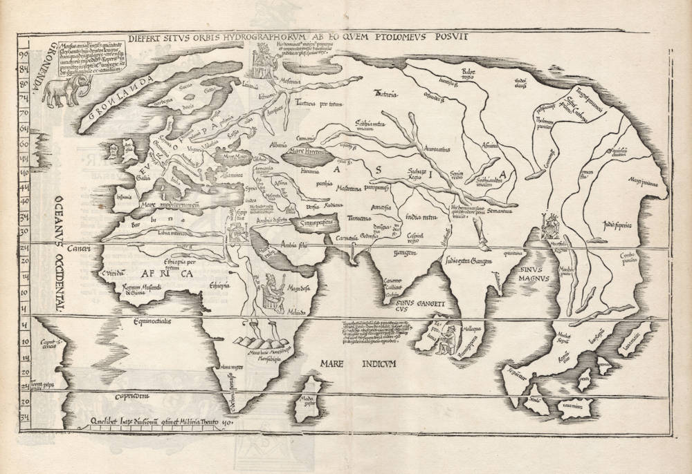
The Mapping of the World
The second modern world map in Fries' Ptolemaic atlas is placed at the very end. It is a reduced version of the corresponding map in Waldseemüller's atlas of 1513 but lacks the criss-cross directional lines. Also only parts of the Americas is shown at the very west of the map.
Fries has added five throned effigies of kings, representing those of Russia, Egypt, Ethiopia, Taprobana, and Mursuli. There is in addition a drawing of an elephant (or perhaps a mammoth [note: this is a common mistake, but a walrus is intended]) placed just off the coast of Greenland. This map is one of the earliest world maps available to a collector, and is an unsophisticated but attractive rendering of what was generally known of the world at that time."
(Rodney Shirley map 49).
The first of Fries' two versions of Waldseemuller's world map.
Fries' own version of Ptolemy's Geographia used, in most cases, reduced copies of the maps from Waldseemüller's own 1513 edition. In Fries' book there are two world maps exhibiting the new discoveries in America. One is based on the 1513 Waldseemüller map (this entry here), while the other although influenced by the Waldseemüller map, is clearly Fries' own work. Both maps are according to Shirley “the earliest world maps that collectors can still obtain...”
This is the first state of Fries' own version of the Waldseemüller 1513 world map, without a second title in a banner above the map. Unlike the other world map, Fries here makes little attempt to add any new geographical content to the Waldseemuller original. America is crudely represented, as is the Cambodian peninsula, which is elongated and curved. Only Java Minor and four other islands are shown in Southeast Asia. Whereas in Fries' other map, Java (Java Maior) and Madagascar are placed next to each other in the middle of the Indian ocean, here Madagascar is correctly positioned and Java is placed halfway up the Chinese coast. There is no mention of Terra Australis Incognita. England and Scotland are shown as separate islands. Little of the new discoveries in America are shown as Fries has effectively “trimmed' off part of the left-hand side of Waldseemüller's original map. Fries has added pictorial representations of the kings of Russia, Egypt, India, Taprobana and Mursuli and includes an elephant at the top left-hand side.
Shirley notes that Waldseemüller's original 1513 map was probably drafted several years earlier as it is generally geographically outdated in comparison with his own magnificent 1507 world map (Shirley 26). Part of the indecision towards geographical knowledge is amply shown by the portrayal of two large peninsulas east of India. The Malay Peninsula is shown to be far shorter than the Thai Peninsula, which in turn bends to the west. The China Sea is disproportionately large.
(Simon Dewez)
History of Cartography
[The 1513 prototype] is known as 'the Admiral's map', since it is mentioned in the preface as 'per Admiralem quondam serenissimi Portugaliae regis Ferdinandi ceteros denique lustratores verissimis peregrinationibus lustrata ...', and the admiral has been assumed to be Columbus himself. [Note that Spain was intended here, not Portugal].
(Leo Bagrow).
Transcriptions and translations of the text legends on the map
The geography of Fries' world map follows Waldseemüller's 1513 atlas map of the world, but Fries has added a few images and text legends that come from Waldseemüller's newer 1516 wall map of the world that had been published in the meantime.
Chet van Duzer has transcribed and translated these texts, as follows:
Upper left, next to GRONLANDA:
Morsus animal ingens quantitate Elephantis huius dentes longos duos et quadrangulares carensque iuncturis in pedibus. reperitur in promontoriis septentrionalibus Norbegie incedit gregatim agmine ducentorum animalium.
[The walrus is a huge animal, the size of an elephant, and it has two long teeth which are quadrangular, and lacks joints in its legs. It is found in the northern promontories of Norway, and they travel together in groups of two hundred animals.]
The legend certainly indicates Waldseemüller’s access to a recent source from Scandinavia, but we do not know what that source was: it was not any of the books that he lists in the long text block on sheet 9 of the Carta marina.
In 1519, a few years after the Carta marina was printed, the Norwegian archbishop Erik Walkendorf sent Pope Leo X the salted head of a walrus, and it was displayed in the city hall in Strasbourg; a sketch of a whole walrus was made based on this head in 1519, and in 1521 Albrecht Dürer sketched the head of a walrus using an unknown model. Despite the availability — at least in some circles — of these quite accurate renderings of walruses, Waldseemüller’s elephant-like depiction was copied on a number of later maps, including the 1522 (Strasbourg), 1525 (Strasbourg), 1535 (Lyon), and 1541 (Vienna) Fries editions of Ptolemy’s Geography, Lorenz Fries’s Carta marina, Olaus Magnus’s Carta marina of 1539, the Vallard Atlas of c. 1547, and Pierre Desceliers’s world map of 1550.
Upper center, under the title:
Hic dominator Magnus princeps et Imperator Russie et Moscovie podolie ac plescovie rex.
[Here the ruler is the great prince and Emperor of Russia and Moscow, the king of Polodia and Plescovia.]
This legend is right next to an image of the Emperor, who is above Moscow, which is where we are to understand that he resides. The use of the title “Emperor” is politically significant, as the use of this title by Princes of Moscow was controverted at this period.
The image of the Emperor emphasize the Christianity of him and of Moscow: the Emperor wears a crown that looks rather like a bishop’s miter; in his hand there is a staff topped by a cross.
Central Asia, near the source of the Ganges:
Hic homines sunt solo odore cuiusdam pomi vivunt.
[Here are men who live just on the odor of a certain apple.]
The text comes from d’Ailly, Ymago mundi, Chap. 16. This race is often called the astomoi or “mouthless men,” and while Strabo 15.1.57 and Pliny 7.2.25 say that they do not have mouths, many other authors do not say that they lack mouths, only that they live just on the odor of apples. Pierre d’Ailly and other writers locate this race near the source of the Ganges.
In the middle of the Indian Ocean:
Taprobanam insulam sub equatoris circulo constitutam Ptolomeus directe retulit. Solinus autem secus ostendit, ubi septentriones nequaquam conspici et virgilie nunquam apparere illic posse. Lunamque ab octava in sextam decimam tantum supra terram videri, quod ac etiam Portugaliensium nauigatio hac positione clarissime aprobat.
[Ptolemy unambiguously indicates that Taprobana is located on the equator. But Solinus shows otherwise, as the northern stars cannot be seen there, and the Pleiades can never appear there. The moon is only above the horizon there from the eighth to the sixteenth day of the month, and the Portuguese voyages in this area unambiguously confirm this.]
Ptolemy locates Taprobana on the equator in his Geography 7.4, and the passage from Solinus is in Polyhistor 53. On the Carta marina Waldseemüller uses many fewer ancient authorities generally, and much less of Ptolemy in particular, whom he had so eagerly embraced on the 1507 map, and this legend is a good example of his turn against Ptolemy — though on the other hand he is citing another ancient authority, Strabo. This legend seems to have been composed by Waldseemüller rather than being a summary of something in one of his sources.
(Chet van Duzer)
Laurent Fries (c.1490-c.1532)
Laurent Fries (Laurentius Frisius), born in Mulhouse in Burgundy, travelled widely, studying as a physician and mathematician in Vienne, Padua, Montpellier and Colmar before settling in Strassburg. There he is first heard of working as a draughtsman on Peter Apian's highly decorative cordiform World Map, published in 1520. Apian’s map was based on Waldseemüller's map of 1507 which no doubt inspired Fries's interest in the Waldseemüller Ptolemy atlases of 1513 and 1520 and brought him into contact with the publisher, Johannes Grüninger. It is thought that Grüninger had acquired the woodcuts of the 1520 edition with the intention of producing a new version to be edited by Fries. Under his direction the maps were redrawn and although many of them were unchanged, except for size, others were embellished with historical notes and figures, legends and the occasional sea monster. Three new maps were added.
There were four editions of Fries' reduced sized re-issue of Waldseemüller's Ptolemy atlas:
1522 Strassburg: 50 woodcut maps, reduced in size, revised by Laurent Fries (Laurentius Frisius) and included the earliest map showing the name ‘America' which is likely to be available to collectors
1525 Strassburg: re-issue of 1522 maps
1535 Lyon: re-issue of 1522 maps, edited by Michael Servetus who was subsequently tried for heresy and burned at the stake in 1553, ostensibly because of derogatory comments in the atlas about the Holy Land – the fact that the notes in question had not even been written by Servetus, but were copied from earlier editions, left his Calvinist persecutors unmoved
1541 Vienne (Dauphiné): re-issue of the Lyon edition - the offensive comments about the Holy Land have been deleted
(Moreland and Bannister)
Martin Waldseemüller (c.1470-1518)
Waldseemüller, born in Radolfzell, a village on what is now the Swiss shore of Lake Constance, studied for the church at Freiburg and eventually settled in St Dié at the Court of the Duke of Lorraine, at that time a noted patron of the arts. There, in the company of likeminded savants, he devoted himself to a study of cartography and cosmography, the outcome of which was a world map on 12 sheets, now famous as the map on which the name “America’ appears for the first time. Suggested by Waldseemüller in honour of Amerigo Vespucci (latinised: Americus Vesputius) whom he regarded, quite inexplicably, as the discoverer of the New World, the new name became generally accepted by geographers before the error could be rectified, and its use was endorsed by Mercator on his world map printed in 1538. Although only one copy is now known of Waldseemüller's map and of the later Carta Marina (1516) they were extensively copied in various forms by other cartographers of the day.
Waldseemüller is best known for his preparation from about 1507 onwards of the maps for an issue of Ptolemy's Geographia, now regarded as the most important edition of that work. Published by other hands in Strassburg in 1513, it included 20 ‘modern' maps and passed through one other edition in 1520. Four more editions on reduced size were issued of the Laurent Fries version.
It remained the most authoritative work of its time until the issue of Münster's Geographia in 1540 and Cosmographia in 1544.
(Moreland and Bannister)