Leen Helmink Antique Maps & Atlases
www.helmink.com
Houtman
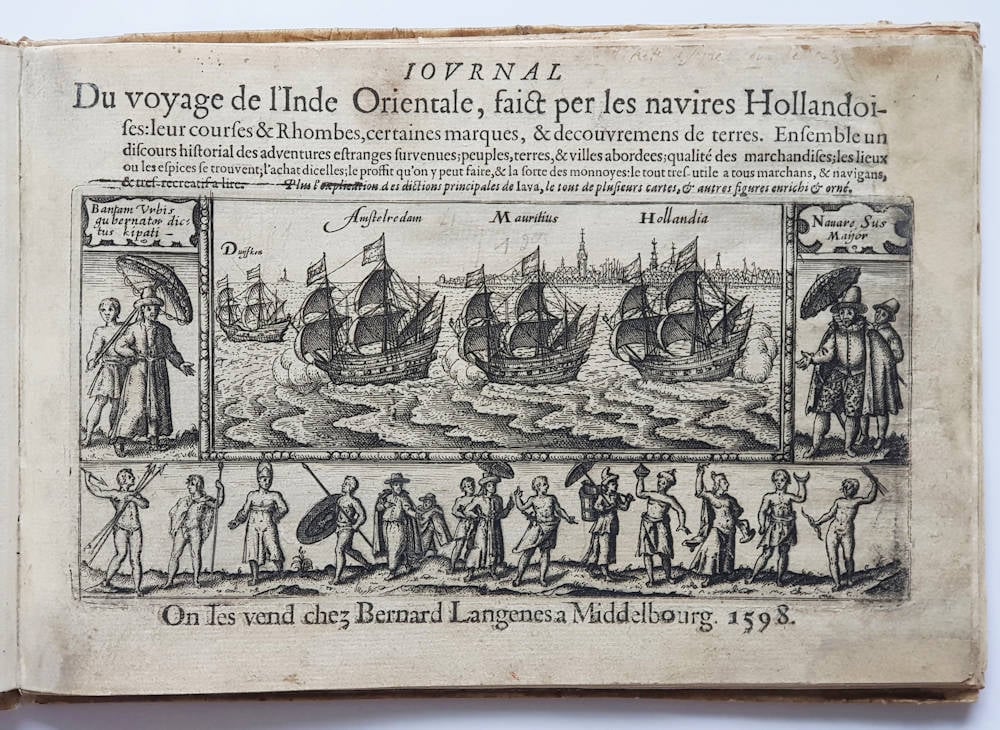
IOURNAL Du voyage de l'Inde Orientale, faict par les navires Hollandoises
Certificate of Authentication and Description
This is to certify that the item illustrated and described below is a genuine antique
map, print or book that was first produced and published in 1597, today 429 years ago.
June 27, 2026
Cartographer(s)
Houtman
First Published
Middelburg, 1597
This edition
1598 first French edition
Size
cms
Technique
Copper engraving
Stock number
19021
Condition
excellent
Description
Enter the Dutch
The dreams and labours of Petrus Plancius and Jan Huyghen van Linschoten culminated in the Dutch First Fleet to the Indies taking place from 1595 to 1597. It was instrumental in the opening up of the Indonesian spice trade to the merchants that would soon form the United Dutch East India Company (VOC). This famous pioneering voyage, commanded by Cornelis de Houtman, would abruptly end the Portuguese Empire ́s trade monopoly for the East and it would dramatically change the Indian Ocean theatre, notably the balance of power and the rules of trade. Right from this first voyage onward, the Dutch were going to dominate the East Indies and its trade for more than 350 years.
Already in 1597, shortly after the return of the first fleet, the Middelburg publisher Barent Langenes published an acclaimed account of the first voyage, predating the Lodewijcksz account published by Cornelis Claesz in Amsterdam. The journal was immediately translated by John Wolfe who issued the English version a few months later. The journal’s title page shows the fleet setting sail from Amsterdam roadstead.
The voyage is of seminal importance to the exploration and the cartography of the region.
Cornelis de Houtman (1565-1599)
Cornelis de Houtman, born in 1565 in Gouda, the Netherlands, was a pivotal figure in the Age of Exploration. He is best remembered as the commander of the first Dutch fleet to the East Indies (modern-day Indonesia) from 1595 to 1597. This expedition marked the beginning of Dutch efforts to establish a foothold in the lucrative spice trade, ultimately leading to the rise of the Dutch East India Company (VOC).
Early Life and Context
Cornelis de Houtman grew up during a transformative period in European history. The late 16th century was marked by the struggle for independence of the Dutch Republic from Spain, as well as fierce competition among European powers for dominance in the spice trade. Portugal had established a monopoly over the trade routes to Asia, particularly to the East Indies, by the early 16th century. However, the defeat of the Spanish Armada in 1588 and growing dissatisfaction with Portuguese control spurred the Dutch to seek direct access to Asian markets.
De Houtman and his brother Frederick were merchants with connections to Amsterdam’s prominent trading community. In 1592, they were sent to Lisbon to gather intelligence about Portuguese trade routes to Asia. Their observations would later inform the plans for a Dutch voyage to the East Indies.
The First Voyage to the East Indies (1595–1597)
In 1595, Cornelis de Houtman was appointed to lead a fleet of four ships — Amsterdam, Hollandia, Mauritius, and Duyfken — in what became known as the "First Dutch Fleet." Sponsored by a consortium of Amsterdam merchants known as the Compagnie van Verre ("Company of Distant Lands"), the voyage was an ambitious but perilous endeavor.
The fleet departed from Texel in April 1595, with approximately 250 crew members. The voyage was plagued by challenges, including inadequate navigation charts, harsh weather, scurvy, and conflicts among the crew. Despite these difficulties, the expedition reached the Sunda Strait (between Sumatra and Java) in June 1596. They established contact with the Sultanate of Banten, a major hub for the spice trade.
Relations with the local rulers quickly soured due to de Houtman's abrasive behavior and lack of diplomatic finesse. Hostilities broke out, forcing the fleet to leave Banten without securing a trade agreement. The fleet also explored Madura and Bali, where they managed to acquire a modest cargo of spices, including pepper.
The return journey to the Netherlands was equally arduous. Disease and hunger took a severe toll on the crew, with only 87 of the original 250 surviving the voyage. Despite its challenges, the expedition proved that it was possible for Dutch ships to reach the East Indies and return with valuable goods.
Legacy and Impact
Although the expedition was not an immediate financial success, it was a landmark achievement in Dutch maritime history. It demonstrated that the Portuguese monopoly on the spice trade could be challenged and paved the way for subsequent Dutch expeditions. Cornelis de Houtman became a symbol of Dutch ambition and resilience, even as his leadership style drew criticism for its harshness and lack of diplomacy.
The information gathered during the voyage laid the groundwork for future expeditions. Within a few years, the Dutch would establish more permanent trade routes and trading posts in the East Indies. In 1602, the Dutch East India Company (VOC) was founded, becoming a dominant force in global trade for the next two centuries.
Final Years and Death
Cornelis de Houtman did not live to see the full fruits of his pioneering efforts. In 1599, he joined another expedition to the East Indies, this time under the command of his brother Frederick. While in Aceh (northern Sumatra), de Houtman became embroiled in a violent conflict with the Sultan of Aceh. He was killed during a skirmish, ending his tumultuous career.
Conclusion
Cornelis de Houtman's first voyage to the East Indies was a milestone in the Dutch Republic’s rise as a global maritime power. His determination and leadership, despite their flaws, opened new horizons for Dutch traders and helped usher in an era of prosperity and dominance in the spice trade. Today, de Houtman is remembered as a trailblazer whose efforts marked the beginning of the Dutch Golden Age.