Leen Helmink Antique Maps & Atlases
www.helmink.com
Willem Lodewijcksz
Prima Pars Descriptionis Itineris Navalis in Indiam Orientalem.
Certificate of Authentication and Description
This is to certify that the item illustrated and described below is a genuine antique
map, print or book that was first produced and published in 1598, today 428 years ago.
August 3, 2026
Cartographer(s)
Willem Lodewijcksz
First Published
Amsterdam, 1598
This edition
1598 first Latin edition
Size
cms
Technique
Copper engraving
Stock number
19016
Condition
excellent
Description
Enter the Dutch
The dreams and labours of Petrus Plancius and Jan Huyghen van Linschoten culminated in the Dutch First Fleet to the Indies taking place from 1595 to 1597. It was instrumental in the opening up of the Indonesian spice trade to the merchants that would soon form the United Dutch East India Company (VOC). This famous pioneering voyage, commanded by Cornelis de Houtman, would abruptly end the Portuguese Empire ́s trade monopoly for the East and it would dramatically change the Indian Ocean theatre, notably the balance of power and the rules of trade. Right from this first voyage onward, the Dutch were going to dominate the East Indies and its trade for more than 350 years.
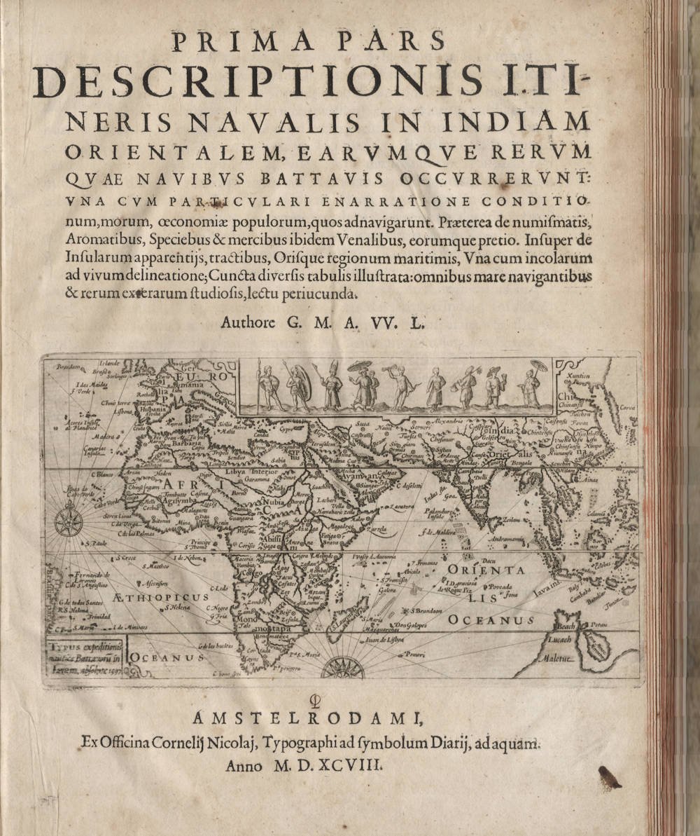
Already in 1598, shortly after the return of the first fleet, the Amsterdam publisher Cornelis Claesz published an acclaimed account of the first voyage, written by Willem Lodewijcksz, an officer on the fleet. The journal was an instant success that sold in many editions and was translated in several languages. The journal’s title page has a small overview map of the route
Willem Lodewijcksz
Prima Pars Descriptionis Itineris Navalis in Indiam Orientalem.
Amsterdam: Cornelis Claesz, 1598.
Folio (31.5 x 24 cms approx.), 51ff., including engraved title, 48 ½- or ¾-page engraved plates (of which 7 are maps), many woodcuts of coastal profiles (some full-page), one engraving of coins printed on a leaf at the end not integral to a signature.
Lacking the double-page plate of the Bantam Market as usual. Tiele (1867), pp. 127, no. 112, "Cette planche manque dans beaucoup d'exemplaires." [This plate is not present in many copies, the book was usually issued without it].
Contemporary vellum. An excellent, well-margined copy.
First Latin edition of this important journal of Cornelis de Houtman's voyage, the first Dutch fleet to the East Indies of 1595-97, extensively illustrated with more than 48 engraved illustrations of the geography, people and natural history of primarily Java and Bali.
According to Lach, this travel journal ‘provided European readers with the most detailed descriptions of Java to date and with the first continuous description of Bali in any language’. In 1598, the year after the return, Lodewyckszoon's account of the voyage instigated 'a flurry of activity among Dutch entrepreneurs' and no fewer than 25 ships set out from two provinces of Holland to the East Indies. Within a period of 18 months, the Dutch had established three trading posts in the Indies which became the foundation of their future control of the Moluccan spice trade and provided a foothold from which to launch further voyages eastward.
This first Dutch venture to the East Indies was instigated by Plancius and by Linschoten's Itinerario. Following their advice, the route took them across the Indian Ocean to the Sunda Straits. He stopped at Sumatra, engaged in trading in Bantam, and made further stops on the northern coast of Java. Lach emphasizes the importance of Lodewijcksz as the 'first eyewitness account of growing pepper and of coconut palms, along with descriptions of the people and other sights on the west coast of Sumatra'. The material on Java is very important, with elaborate ethnographical descriptions: there is an account of the institution of polygamy, a detailed description of a Javan wedding, music, dance, the writing system, language etc. The chapters on Bali present the first account and the first images and the first map of the island.
Lodewyckszoon's accurate coastline profiles were employed by later Dutch fleets, and the plates are among the earliest visual impressions formed by Europeans of this part of the world (Lach reproduces no less than a dozen). Some of the more interesting depict the merchants in Bantam (Peguan, Persian, Arab and Chinese), a Chinese temple (actually Hindu, the original religion which then still had presence on Java), the King of Bali in his ox-drawn chariot, a Javanese gamelan orchestra and a depiction of Javanese court dances (probably Gambang or Bedhaya).
The work appeared the same year in Dutch and French from the same publisher and went through a number of later editions, but the universality of this first Latin edition gave Lodewyckszoon's account its widest possible readership and makes it the best of the 1598 first editions and the best edition overall.
Tiele, Memoire Bibliographique sur les Journaux des Navigateurs Neerlandais, p127.
Lach, Asia in the Making of Europe, III, 1.438-9 & III, 3. 1222-34.
Lodewijcksz journal as a first
The Lodewijcksz journal is a first in many ways.
- first Dutch fleet to the Indies
- first printed ship's journal/log of a voyage of discovery
- first images of the Duyfken
- first ethnographic images of daily life in the Indian Ocean, Java, Sumatra, Bali
- first nautical profiles of the coasts of these areas
- first maps and views of Bantam
- first maps and views of Bali
- first printed images of the coins used in the area for trade
The voyage is of seminal importance to the exploration and the cartography of the region.
Willem Lodewijcksz
Willem Lodewijcksz was a Dutch naval officer and author, known for his detailed account of the first Dutch expedition to the East Indies from 1595 to 1597. This pioneering voyage, led by Cornelis de Houtman, marked the beginning of Dutch involvement in the spice trade and the establishment of the Dutch East India Company (VOC).
Lodewijcksz's journal, titled D'eerste boeck: Journal ofte beschrijvinghe van de reyse gedaen by de Hollandtsche schepen, provides a comprehensive narrative of the expedition. It offers insights into the challenges faced during the journey, interactions with local populations, and observations of the regions visited. His work is considered one of the earliest and most valuable Dutch accounts of Southeast Asia.
While specific personal details about Lodewijcksz are scarce, his contributions as a chronicler have been instrumental in understanding early Dutch maritime exploration and the subsequent expansion into the East Indies.
We do know from his own journal and from other sources that he was well educated in navigation and in commerce, and that he was fluent in Spanish, Portuguese and Italian.
He was important enough to take part in the ship's councils during the expedition, and was part of commercial and navigational decisions.
Possibly worried about repercussions for spreading secret information, the journal's author is named only as "G.M.A.W.L.", which was only centuries later deciphered as
G(uillaume) M(..) A(lias) W(illem) L(odewycksz)
.Interestingly, he was added to the fleet at the very last minute, on the day it was sailing, after it had already spent 10 days of waiting for favourable winds at Texel roadstead. He was added by the Amsterdam faction venture capitalist investors of the fleet, as an "Adelborst", a gentleman officer. These were the well educated young sons of successful citizens brave enough to risk their lives for a steep career in commerce and navigation.
As IJzerman notes:
On the final day of the ships' stay, Saturday, April 1, 1595, so to speak, at the very last moment, Lodewycksz came aboard the Amsterdam. He was accompanied by "some" of the shipowners (who exactly?) and had traveled from Amsterdam to Texel on Wednesday, March 29. The ships had already been anchored there since March 21, while some cadets, including Van der Does, had also traveled overland to Texel on Easter Sunday, March 26.
At the very last moment, Lodewycksz was extraordinarily appointed to the ship bearing the name of the departing Amsterdam. As evidenced by his entire First Book, he acted as a "mediator" between the factions that were noticeable from the very beginning: those on the Mauritius, the Prince's ship, led by Cornelis de Houtman as the senior merchant, and those on the Hollandia, the States' ship, where Houtman's fierce rival Gerrit van Boninghen served as merchant.
Lodewycksz was able to participate in the entire voyage and, in the end, omitting or glossing over all disputes, was able to write the official account of the First Expedition on behalf of the Amsterdam shipowners.