Leen Helmink Antique Maps & Atlases
www.helmink.com
Mercator
Septentrionalium Terrarum descriptio
Certificate of Authentication and Description
This is to certify that the item illustrated and described below is a genuine antique
map, print or book that was first produced and published in 1595, today 431 years ago.
June 23, 2026
Cartographer(s)
Mercator
First Published
Duisburg, 1595
This edition
1613 Latin edition
Size
36.5 x 39.2 cms
Technique
Copper engraving
Stock number
19005
Condition
excellent
Description
Stunning full-bodied original colour. Excellent condition. Early imprint, from the 1613 Latin edition of the Mercator-Hondius atlas. The best example that we have ever seen. A very desirable collector's copy.
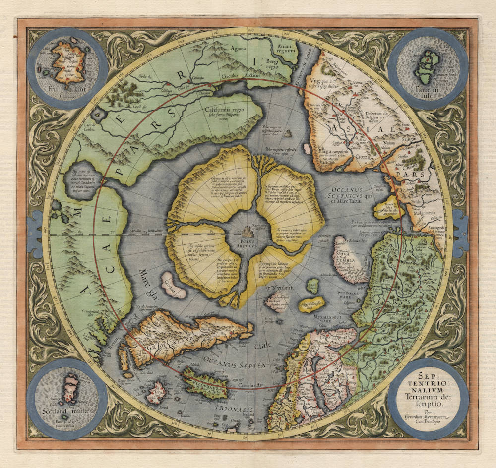
The first map dedicated to the Arctic and the North Pole, by the great Gerard Mercator. An excellent example of this collector's map, famous for it's myths and legends and its decorativeness and delightful composition.
Elements from Medieval sources are combined with the latest explorations by the English and the Dutch. In this second state Barentsz's discoveries have been included. The North Pole is depicted as a large rock from which four rivers flow, through four surrounding islands. The source for this knowledge was a now lost book, the Inventio Fortunata.
Curiously, California is situated above the Arctic circle, with the following text legend:
Califormia regio / Sola fama Hispanis nota
California region / known to the Spanish by hearsay only
Note that Califormia is spelled with an "m", which was not unusual at the time.
Separate insets are in the corners of the map, with the mythical island of Friesland, the Shetlands and the Faroer.
The land of Gog is situated in North-East Tartaria, at the far end of Asia.
The Mapping of North America
SEPTENTRIONALIVM Terrarum descriptio.
Per Gerardum Mercatorum
Cum Privilegio
Duisburg, 1595.
Copperplate engraving, 365 x 380 mm.
From:
Atlantis Pars AlteraThe author of this map, Gerard Mercator, died in December 1594; it was left to his son Rumold to publish it in the last of the three parts that formed his father's famous atlas, the Atlantis Pars Altera. This is the first map devoted to the Arctic, a hemispherical one on a North Polar projection with an attractive floral design surrounding it. In the corners are four roundels, one of these contains the title, the other three contain maps of the Faeroe Isles, the Shetland Isles and the mythical island of Frisland. The map is largely derived from the inset of the same area on his great world map of 1569. Here, however, its scope is enlarged to the latitude of 60 degrees; this enabled him to depict the recent attempts at finding the North West and North East Passages. The results of Frobisher's and Davis' attempts are recorded, largely derived from Cornelis Claesz's map of the previous year, or possibly Mercator had seen an example of the Emery Molineux globe produced in London, 1592.
Califormia is identified as Spanish territory and El streto de Anian is clearly shown. The pole itself is made up of our surrounding islands, which myth had it were separated by four strong flowing rivers. These carried the oceans of the world towards a giant whirlpool at the pole where there stood a large rock. Fortunately for us there survives an account of this myth in Mercator's own hand. John Dee of London had written to him inquiring as to what he based his cartography on. Mercator's reply is reproduced in 'Imago Mundi' 13.
There was one further edition of the atlas in Duisburg in 1602. In 1604 the plates were sold to Jodocus Hondius who updated the plate with new information. This second state was published in his first edition in Amsterdam 1606. It continued to be used until being replaced in 1636 with a map by Henricus Hondius.
- State 1: 1595. Showing four islands around the pole, all with complete coastlines.
- State 2: 1606. All changes occur to the north of Russia; the one island of the four that is lower right now has an incomplete coastline. Nova Zembla is now one island but has an incomplete coast.
(Philip Burden map 88)
Gerard Mercator (Kremer) 1512-1594
Arnold Mercator (son) 1537–1587
Rumold Mercator (son) c. 1545– c. 1599
Bartholomeus Mercator (son) fl. 1540-1563
Gerard Mercator (grandson) c. 1563-1656
Joannes Mercator (grandson) c. 1562-1595
Michael Mercator (grandson) c. 1567–1600
For nearly sixty years, during the most important and exciting period in the story of modern map making, Gerard Mercator was the supreme cartographer, his name, second only to Ptolemy, synonymous with the form of map projection still in use today. Although not the inventor of this type of projection he was the first to apply it to navigational charts in such a form that compass bearings could be plotted on charts in straight lines, thereby providing seamen with a solution to an age-old problem of navigation at sea.
His influence transformed land surveying and his researches and calculations led him to break away from Ptolemy conception of the size and outline of the Continents, Drastically reducing the longitudinal length of Europe and Asia and altering the shape of the Old World as visualized in the early sixteenth century.
Mercator was born in Rupelmonde in Flanders and studied in Louvain under Gemma Frisius, Dutch writer, astronomer and mathematician. He established himself there as a cartographer and instrument and globe maker, and when he was twenty-five drew and engraved his first map (of Palestine) and went on to produce a map of Flanders (1540) supervising the surveying and completing the drafting and engraving himself.
The excellence of his work brought him the patronage of Charles V for whom he constructed a globe, but in spite of his favour with the Emperor he was caught up in the persecution of Lutheran protestants and charged with heresy, fortunately without serious consequences. No doubt the fear of further persecution influenced his move in 15 s 2 to Duisburg, where he continued the production of maps, globes and instruments culminating in large-scale maps Europe (1954), the British Isles (1564) and the famous World Map on 18 sheets drawn to his new projection (1969). All these early maps are exceedingly rare, some being known by only one copy.
In later life he devoted himself to his edition of the maps in Ptolemy's Geographia, reproduced in his own engraving as nearly as possible in their original form, and to the preparation of his 3-volume collection of maps to which, for the first time, the word 'Atlas' was applied. The word was chosen, he wrote, 'to honour the Titan, Atlas, King of Mauritania, a learned philosopher, mathematician and astronomer'. The first two parts of the Atlas were published in 1583 and 1589 and the third, with the first two making a complete edition, in 1595, the year after Mercator's death.
Mercator's sons and grandsons, named above, were all cartographers and made their contributions in various ways to the great atlas. Rumold, in particular, was responsible for the complete edition in 1595. After a second complete edition in 1602, the map plates were bought in 1604 by Jodocus Hondius who, with his sons, Jodocus II and Henricus, published enlarged editions which dominated the map market for the following twenty to thirty years.
(Moreland & Bannister).