Leen Helmink Antique Maps & Atlases
www.helmink.com
Münster
INDIA EXTREMA XIX NOVA TABULA
Certificate of Authentication and Description
This is to certify that the item illustrated and described below is a genuine antique
map, print or book that was first produced and published in 1540, today 486 years ago.
July 1, 2026
Cartographer(s)
Münster
First Published
Basle, 1540
This edition
1550 German
Size
27.0 x 34.0 cms
Technique
Woodcut
Stock number
19004
Condition
excellent
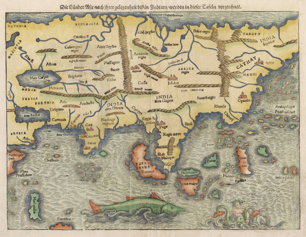
Description
The first map dedicated to the Asian continent and the earliest map of the region "that collectors can possibly hope to acquire".
Early imprint, from the 1550 German edition, in original color, which is exceptionally rare for this map. A very desirable collector's item.
Here from the early German 1550 edition. The title is here typeset in German as follows:
Die Länder Asie nach ihrer gelegenheit biß in Indiam werden in dieser Tafeln verzeichnet.
[ The countries of Asia in their locations all the way to the Indies are depicted in this map]
.This first map of Asia combines elements from antiquity (Ptolemy's Scythia, Serica), from medieval accounts (Marco Polo's Cathay, Quinsay, Archipelagus 7448 insularum, Zanzibar), from the latest Portuguese discoveries (Calicut, Malaqua), and from the discoveries of Magellan's circumnavigation (Puloan).
A double-tail mermaid is shown in the location of undiscovered Australia, and a large fish covers the center of the Indian Ocean.
The title on verso of the map has decorations all around that are attributed to the most famous artist Hans Holbein the Younger, a friend of Sebastian Münster.
Early Maping of Southeast Asia
Münster's general map of Asia is based on the reports of the Portuguese, Arabs, and Marco Polo. It includes an extremely early depiction of the Philippines (Palawan).
(Thomas Suárez).
Sebastian Münster (1489-1552)
Following the various editions of Waldseemüller's maps, the names of three cartographers dominate the sixteenth century: Mercator, Ortelius and Münster, and of these three Münster probably had the widest influence in spreading geographical knowledge throughout Europe in the middle years of the century.
His Cosmographia, issued in 1544, contained not only the latest maps and views of many well-known cities, but included an encyclopaedic amount of detail about the known - and unknown - world and undoubtedly must have been one of the most widely read books of its time, going through nearly forty editions in six languages.
An eminent German mathematician and linguist, Münster became Professor of Hebrew at Heidelberg and later at Basle, where he settled in 1529. In 1528, following his first mapping of Germany, he appealed to German scholars to send him "descriptions, so that all Germany with its villages, towns, trades, etc. may be seen as in a mirror", even going so far as to give instructions on how they should "map" their own localities. The response was far greater than expected and such information was sent by foreigners as well as Germans so that, eventually, he was able to include many up-to-date, if not very accurate, maps in his atlases.
He was the first to provide a separate map of each of the four known Continents and the first separately printed map of England. His maps, printed from woodblocks, are now greatly valued by collectors. His two major works, the Geographia and the Cosmographia were published in Basle by his step-son, Henri Petri, who continued to issue many editions after Münster's death of the plague in 1552.
(Moreland & Bannister).
The remaining modern maps, [...], are all drawn on a plane projection, undergraduated, without scales, and variously oriented with north, south, east or west at the top, "without the excuse of topographical necessity", as Nordenskjöld severely remarks. In spite of these and other cartographic defects, they constitute an important corpus of geographical knowledge and interpretation; Münster was the first atlas-maker to furnish separate maps of the four continents then known; and for England, Scandinavia and southern Germany, eastern Europe and America he brought recent and significant representations into general currency.
(Skelton).
The Cosmographia of Sebastian Münster must rank as the greatest geographical compendium of the period - an immensely detailed work illustrated with woodcut portraits, scenes, town plans and panoramas, and maps. Born in 1488, Münster was a Fransiscan who became Professor of Hebrew at Heidelberg and later at Basle, where he taught Hebrew and, amongst other works, published the first German translation of the Bible from Hebrew. In 1540 his edition of Ptolemy's Geographia was published, followed in 1544 by the Cosmographia Universalis. Together these ran to over 35 editions published mostly in Basle in Latin, German, French and Italian versions. Münster's particular cartographic importance lies in the number of 'new' maps he introduced and, above all, in the innovative, separate mapping of each of the four continents. The map of the Americas is not only the first map to show the Western Hemisphere separately, but is also the first to show North and South America joined together.
(Potter p38).
Sebastian Münster was raised as a Franciscan monk, converted to Lutheranism, taught Hebrew at Heidelberg and Basle, and was proficient in Greek and some Asian tongues. He died of the plague in 1552. First published in 1540, his atlas was the first to contain separate maps of each of the four continents.
(Suárez).
In 1540 Sebastian Münster, who was to become one of the most influential cartographers in the sixteenth century, published his edition of Ptolemy's Geographia with a further section of modern, more up-to-date maps. He included for the first time a set of continental maps, the America was the earliest of any note. Münster studied Hebrew at Heidelberg and was a scholar of geography, writing amongst other works the Polyhistor.
He was one of the first to create space in the woodblock for the insertion of place-names in metal type. The map's inclusion in Münster's Cosmography, first published in 1544, sealed the fate of "America" as the name for the New World. The book proved to be very popular, there being nearly forty editions during the following 100 years.
(Burden).