Leen Helmink Antique Maps & Atlases
www.helmink.com
Willem Blaeu
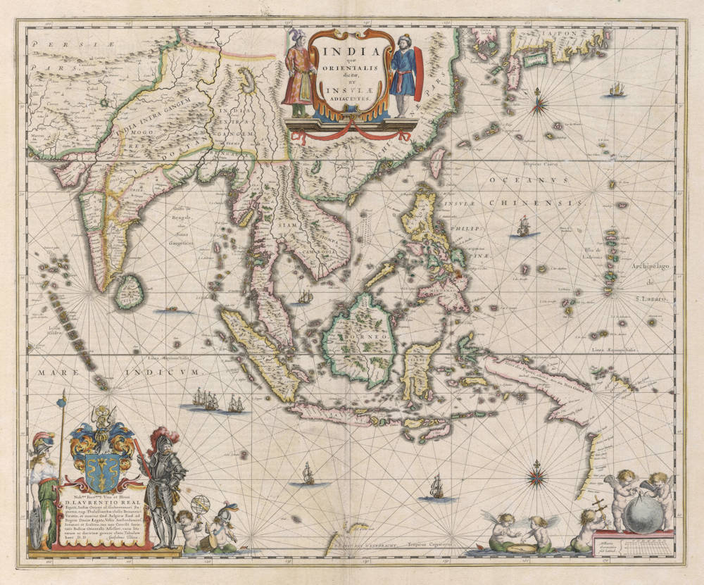
India quae Orientalis dicitur, et Insulae Adiacentes.
Certificate of Authentication and Description
This is to certify that the item illustrated and described below is a genuine antique
map, print or book that was first produced and published in 1634, today 392 years ago.
July 14, 2026
Cartographer(s)
Willem Blaeu
First Published
Amsterdam, 1634
This edition
1642 German edition
Size
41 x 50 cms
Technique
Copper plate engraving
Stock number
18993
Condition
excellent
Description
One of the best and most famous 17th century maps of the region, from the Golden Age of Dutch cartography. Boldly engraved on a network of rhumb lines, richly embellished with title cartouches, scalebar, compass roses, cherubs and galleons. Printed in black ink from an engraved copperplate, then color paint added by hand.
A seminal map stretching from India to Japan, and one of the first printed maps to show parts of Australia as discovered by the Dutch between 1606 and 1623, before the expeditions of Abel Tasman. Strait Torres between New Guinea and Cape York is not known, although the possibility is left open. Korea is considered to be an island. Japan is very inaccurate, although three main islands are acknowledged. The map shows the first relatively accurate depiction of the complex archipelago of the Philippines.
This striking map of South East Asia and the Far East comes from a series of wonderfully decorative maps by Willem (Guilielmus) Janszoon Blaeu (1571-1638), the progenitor of the famous Blaeu cartographic firm of Amsterdam. Blaeu studied astronomy and sciences with Tycho Brahe, and in 1599 established a globe and instrument making business which soon expanded to include cartographic and geographic publishing. This firm was to go on to become the largest and most important cartographic publishing firm in the world, run by his sons Cornelis (until his death in 1642) and Joan.
The maps issued by the Blaeu firm are known for their fine craftsmanship and design, and have been called the highest expression of Dutch cartographical art. This map, with its excellent original color and clear and precise detail is a premier example of the Blaeu output.
Among mapmakers of the seventeenth century the house of Blaeu is justly recognized as pre-eminent in terms of art, cartography and engraving skills. Additional to the map's aesthetic qualities is its historical significance for the charting and mapping of the region.
At centre top is a title cartouche held by two male costumed figures dressed in Asian livery. In the lower left corner is a Latinized dedication to Laurens Reael (Lavrentio Real) who had served as Governor-General of the Dutch East Indies 1616-1617. Reael had fought the Spanish in 1617 in the Bay of Manila, the English at Bantam and in the Mollucas, and the Mataram Sultanate at Japara on Java. The dedication is signed by Blaeu and is guarded on the left by Athena, the Greek Goddess and symbol of wisdom, courage, inspiration, civilization, law and justice, mathematics, strength, just warfare, strategy, the arts, crafts, and skill. On the right is an armoured knight, to emphasize the Dutch military strenght, firmness and determination. Several cherubs are depicted along the lower border, playing with maritime instruments, to illustrate the importance of the science of navigation.
Blaeu was the official cartographer to the Dutch East India Company (VOC) and as such, was privy to the best available information in the region, long before the information was generally made known to the rest of the map making community. His map of the region reflects his early access to the Dutch explorations in the region during this time period. This map is of utmost importance, as it was the first regional map in an atlas to show the latest Dutch discoveries in the region. Contrary to the Portuguese and Spanish mapmakers, who had no permission to print and publish maps of the new discoveries overseas for reasons of secrecy, the Dutch mapmakers suffered little censorship and enjoyed a large freedom of press.
Hessel Gerritsz, the official cartographer of the VOC, had produced the original copperplate between 1628-1632, but without any decorations or title cartouches. After the death of Gerritsz in 1633, Blaeu took over the position as VOC mapmaker, helped with the appointment by his friend Laurens Reael, who was back in the Netherlands and who was by now one of the VOC directors in Amsterdam.
In his new position Blaeu had access to the latest navigational information available from the East Indies, including all ship's logs and charts. Blaeu also got Hessel Gerritz' copperplate for this map, that had actually been designed as a maritime chart for use at sea by the East India Company. Blaeu changed it from a navigational chart into an atlas map to add to his two volume Atlas Novus of 1634. As a consequence the map is the first accurate atlas map of the region.
Willem Janszoon Blaeu (1571-1638)
Joan Blaeu (son) (1596-1673)
Cornelis Blaeu (son) (?-c.1642)
Willem Jansz. [Blaeu] and his son Joan are the most widely known cartographic publishers of the seventeenth century. Born as the son of a wealthy herring merchant in Alkmaar North Holland, to Anna, a first cousin of Willem. Cornelis Hooft was merchant in oil, grain and herring and twelve times mayor of Amsterdam. He hoped that Willem would take over his business.
But Willem was more interested in mathematics, astronomy and other scientific matters, however, and in 1595 he left for Denmark to study with the astronomer Tycho Brahe on the island of Ven. Brahe had established here his own observatory as well as a workshop for the manufacturing of instruments and a printing office. This enabled young Willem to acquire both theoretical and practical knowledge and provided him with contacts among like-minded people. After his return to the Netherlands he applied himself to astronomy for several years in his native Alkmaar. Here he published his first cartographic work: a celestial globe according to the observations of Tycho Brahe.
At the end of the sixteenth century Willem Jansz. moved with his family to Amsterdam. He set up a shop in celestial and terrestrial globes and nautical instruments, since the rapid growth of seafaring opened a large market for these goods. Soon he was able to offer for sale globes in various sizes. In 1605 Willem Jansz. moved to a new location at the "Op ‘t Water" (today Damrak nr. 46), a house with the sign of in de Vergulde Sonnewijwyser ("in the Gilded Sundial"). Apart from the manufacturing globes, Willem Jansz. published numerous maps and charts in folio size, along with multi-sheet wall maps, town views, and historical prints, all of which are now very rare.
Willem Jansz. made an unmatched contribution to the fields of navigation and cartography. His "Het Licht der Zee-vaert", published in 1608, was of great consequence for navigation in European coastal waters. He used the same oblong-size like Waghenaer did in his "Thresoor der Zeevaert" (1592): the work was constructed in a series of chapters, adding to each chapter sailing-descriptions for a specific stretch of coast and the corresponding chart. The coastal profiles in woodcut have been included in the text of each chapter.
In 1618 another mapmaker, bookseller and publisher, Jan Jansz. (Joannes Janssonius) established himself on the Damrak next door to Willem Jansz.’s shop. Accusing each other of copying and stealing information, the neighbours became fierce competitors. In about 1621, Willem Jansz. decided to put an end to the confusion between his name and his competitor’s and assumed his grandfather’s sobriquet, (Blauwe Willem), as the family name; thereafter he called himself Willem Jansz. Blaeu.
Responding to Janssonius’s plagiarism of "Het Licht der Zeevaert", Blaeu published a new pilot-guide in 1623: the "Zeespiegel", a description of the seas and coasts of the Eastern, Northern and Western Navigation. Approximately the same coastal areas are described as in the older "Het Licht der Zeevaert", but in a much more elaborate way and with a far greater number of charts.
Apart from pilot-guides, Blaeu also published single-sheet charts, often printed on durable vellum. As example attention is here given to the so-called "West-Indische Paskaert", a chart of the Atlantic Ocean in Mercator’s projection, published about 1630. Despite the obvious advantages for navigation, the charts drawn on this projection were only gradually accepted by navigators.
Blaeu was nearing the age of sixty when in 1630 he published his first atlas of the world and began to compete with Henricus Hondius. For many years Blaeu toyed with the idea of publishing his own atlas of the world. The initial material for an atlas was in Blaeu’s hands in the form of his own folio-maps, which he had begun publishing in 1604. Blaeu’s plan gained momentum, however, when he succeeded in 1629 in purchasing a large number of copperplates that had belonged to the late Jodocus Hondius the younger. Blaeu quickly amended these plates by replacing Hondius’s name with his own imprint, a common procedure in those days. In 1630 Blaeu published the "Atlantis Appendix", using his own maps and the amended maps of Jodocus Hondius. The world atlas consists of 60 maps, but without a descriptive text. In 1631 a new world atlas was published , titled "Appendix Theatri A. Ortelii et Atlantis G. Mercatoris", provided with a Latin text and nearly hundred maps. The intention in publishing this atlas was to produce a supplement to the works of the two famous geographers. Henricus Hondius and his brother-in-law Joannes Janssonius immediately took steps in reaction to the publication of Blaeu’s "Appendix" and published amended atlas-publications.
The fierce competition between Blaeu and Hondius-Janssonius greatly influenced the further development of their atlas productions. Blaeu now intended to distance himself completely from Ortelius and Mercator and to publish an entirely new world atlas in four languages. In 1634 a German edition was published, which contains a number of unfinished maps, a sign that the work was done hurriedly in order to have the atlas published in time.
The extent of Blaeu’s ambitious plans for the world atlas is reflected in his preface, where he states that it is his intention to describe the whole world and to depict all the ports and seas, and therefore several other volumes of the atlas were to follow shortly. In view of these plans, Blaeu’s investment in a new printing shop in 1637 is not surprising. Yet Blaeu did not live to see the publication of a new volume. After his death the business was continued by his two sons Joan and Cornelis, the elder of whom had been collaborating on the atlas since 1631. In 1640 a third volume was published (Italy), in 1645 a fourth (England and Wales), in 1654 a fifth (Scotland) and finally in 1655, a sixth volume covered China.
In addition to his activities as publisher, Willem Jansz. Blaeu continued his scientific pursuits. His expertise won official recognition at his appointment as chart maker and examiner of navigating officers by the Amsterdam Chamber of the United Dutch East India Company (VOC).
Blaeu’s new position gave him access to the enormous map archives of the VOC. He performed the function of chart maker until his death in 1638. For his task he employed the four assistants of his deceased predecessor Hessel Gerritsz. Blaeus’s work was most probably limited – given his age – to the supervision of his employees in the manufacture of charts, to the supervision of content and to any alterations and improvements required. A steady stream of charts, required to equip the ships, must have left his workshop. Thanks to his position as chart maker of the VOC, Blaeu was able to expand his world atlas of Asia with new maps and gain the edge on his Amsterdam competitors, Hondius and Janssonius.
Willem Jansz. Blaeu died in October 1638, leaving his prospering business to his sons, Joan and Cornelis.
(Schilder)
Hessel Gerritsz (1581/82-1632)
Master engraver and Map Maker, who 'ruled' the Seas
Hessel Gerritsz. (1580/81) ranks among the most important and influential cartographers of the early-seventeenth-century Amsterdam. He started his career in Willem Jansz. Blaeu's workshop. About 1608 he established himself as an independent engraver, mapmaker and printer.
In his position as chart-maker of the Dutch East India Company (VOC) and West India Company (WIC) he had access to the latest ship logs, he equipped the ships to the east and the west with the latest charts, and was the best informed cartogrepher of the era.
(Schilder)
"Unquestionably the chief Dutch cartographer of the 17th century."
(Keuning)
His fame as cartographer grew rapidly to the point that on 16 October 1617 he was appointed the first exclusive cartographer of the Dutch East India Company (VOC), probably the most strategic position a cartographer could have in those days. He got the position by recommendation of Petrus Plancius, chief scientist and advisor of the VOC, who did not get along with the more senior Willem Blaeu. Gerritsz kept this post until his death in 1632, after which the position was given to Willem Blaeu after all (Plancius had passed away in 1622).
(Wikipedia)
In 1617, Hessel Gerritsz. published a large wall map of Italy in six sheets. His model for the geographical content was the wall map published by Giovanni Antonio Magini (1555-1617) in 1608, which was a milestone in the seventeenth century Italian cartography.45 He gave his wall map an extra cachet by extending the map image with town views and costumed figures. The design of the costumed figures is attributed to Pieter Lastman (1583-1633), the exquisite execution betraying the hand of the master etcher Gerritsz.
Gerritsz.' wall map of Italy was copied shortly after publication by the publishing house of Willem Jansz. [Blaeu]. To protect himself against such plagiarism in the future, he requested a patent from the States General. On 27 January 1618, they granted him a general patent in which amongst other things it was forbidden in any way to reproduce, copy or distribute his maps, descriptions of lands and prototypes ('models') both written or printed. Such an extensive patent was highly unusual, in the most cases a privilege was granted for precisely defined publications. Hessel Gerritsz. was so highly regarded in 1617, that he received such an important privilege from the States General in January 1618, shown by his appointment as instructor in geography for the Councillors of the Admiralty at Amsterdam on 15 July 1617 and as map maker for the Chamber Amsterdam of the VOC on 16 October 1617. With both appointments his old employer Willem Jansz. [Blaeu] was passed over.
With the appointment of Hessel Gerritsz. as map maker of the Chamber Amsterdam – a function which he held until his death in 1632 – the VOC brought a driven person into the house who undertook the organization of equipping the ships with charts and navigational aids with vigour. The instructions issued to him by the Chamber Amsterdam in 1619, give a good insight into what was expected from a map maker of the VOC. Because all merchants, masters and pilots were obliged to deliver the journals, maps and drawings made during the voyage to him on their arrival in Texel, with the aid of this material he was able to improve and expand the charts for the navigation to and from the Indies. The influential position that Hessel Gerritsz. held in equipping the VOC ships with charts cannot be overrated, for within a very short period he developed certain prototypes of charts, which – with some small adjustments – were part of the standard equipment of a VOC ship, sometimes until the middle of the eighteenth century.
(Schilder)