Leen Helmink Antique Maps & Atlases
www.helmink.com
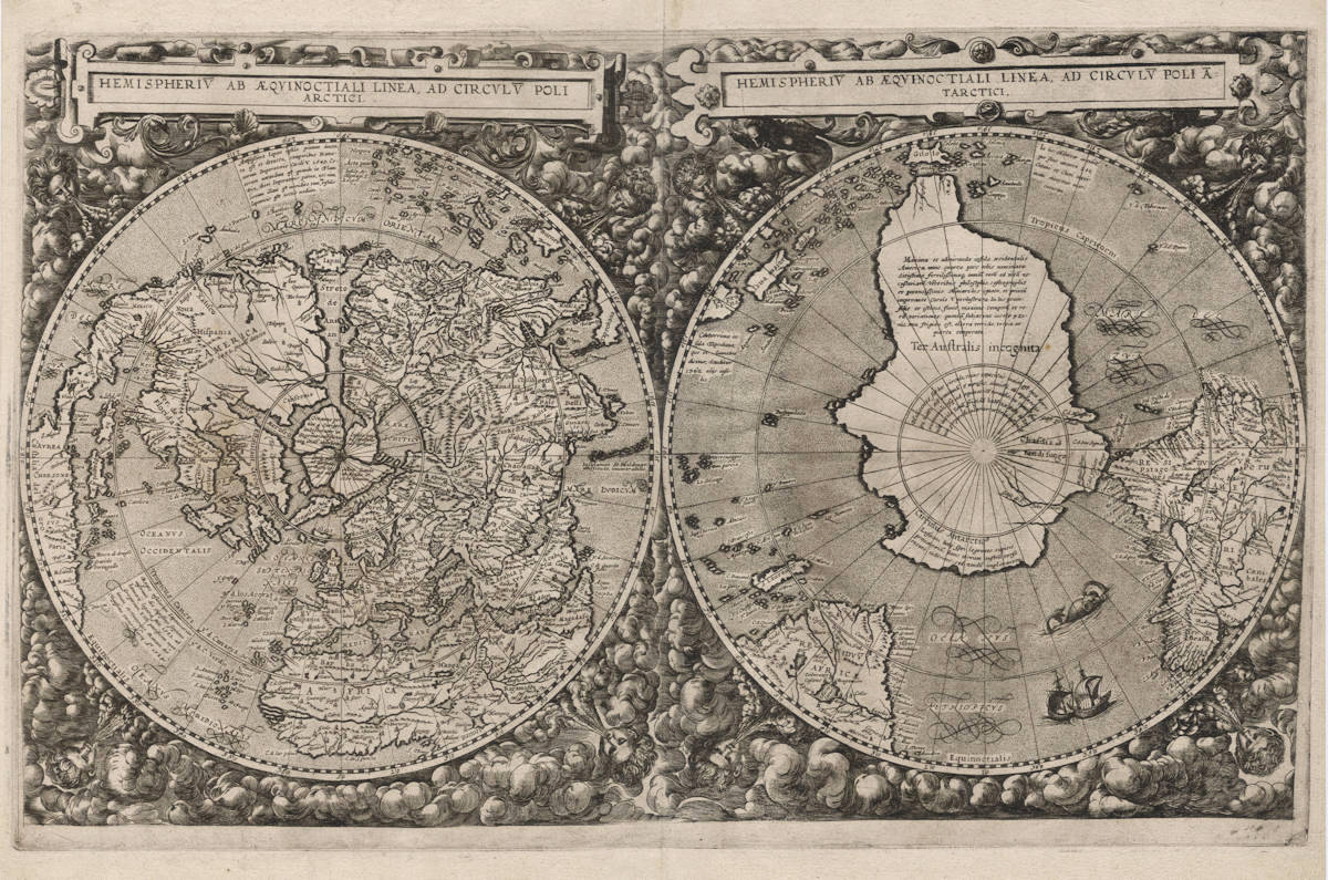
Cornelis de Jode
Hemispheriū Ab Aequinoctiali Linea, Ad Circulū Poli Arctici ... Ad Circulū ...
Certificate of Authentication and Description
This is to certify that the item illustrated and described below is a genuine antique
map, print or book that was first produced and published in 1593, today 433 years ago.
June 23, 2026
Cartographer(s)
Cornelis de Jode
First Published
Antwerp, 1593
This edition
Separate issue pre-1593
Size
32.0 x 52.0 cms
Technique
Copper engraving
Stock number
18991
Condition
mint
Description
Cornelis de Jode's dramatic and decorative map of the world, one of the greatest icons of map collecting. It is one of very few world maps on a twin polar hemisphere projection, allowing for a clear view of the northern and southern polar regions in general, and of the mythical Southland (Terra Australis Incognita) in particular.
Descriptions from the literature
The Mapping of the World
Cornelis de Jode
Antwerp, 1593.
320 x 520 mm.
Hemispheriū Ab Aequinoctiali Linea, Ad Circulū Poli Arctici . . . Ad Circulū Poli Ātarctici.
From: Speculum Orbis Terrae ...
There are two new world maps in the 1593 edition of De Jode's Speculum. The first of these is dated 1589 (Shirley 165). This second is one of relatively few drawn as two hemispheres on north and south polar projections. Surrounding each hemisphere is an elaborate border of cherubs and clouds. There is no acknowledgement as to author, engraver or publisher.
The map is an interesting adaptation of Guillaume Postel's 1581 world map (Shirley 144) with some curious features reminiscent of the large anonymous gores probably published in Antwerp in about 1587 (Shirley 156). In both maps we have the same configuration for the northern coasts — the Gulf of Merosro in North America, the placing of Ter. d Labrador and Nova Zemla, and the odd junction of the eastern part of Asia with one of the large arctic masses. Japan is to be found only a few degrees from the west coast of America, and in the delineation of South Africa and South America there are further features strongly suggesting a common source.
It has been reported that textless map sheets were issued separately prior to the atlas edition of 1593. Wagner, in the first of his references below, implies that the map is inscribed Cornelius de Jode 1590 and lists it under this date. I have not seen any examples with this designation.
The 1593 edition of the Speculum was the last. However an isolated example of a second state was uncovered recently with the southern hemisphere amended to show Le Maire's strait, discovered by Schouten and Le Maire during their passage around Cape Horn in 1616. The De Jode plates (after passing to the publisher Vrients in 1600) came into the hands of the Moretus family who, it is known, had the Ortelius world map plate in their possession reworked in 1628. Possibly Cornelis de Jode's world map was also amended at the same time.
BL Maps C.7.c. 13; LC 398.
Robert Douwma, Catalogue 22, 1979, item 22 (this describes the previously unrecorded second state); Nordenskiöld, p. 95 and plate XLVIII; Schilder, Map 14; R.A. Skelton, Introduction to the Facsimile Edition of De Jode's Speculum Orbis Terrae, Amsterdam, 1965; Wagner 161 and 170.
(Rodney Shirley map 184)
One of the Most Striking World Maps of the 16th Century
This rare, double-polar projection world map, published in only a single edition, was one of the visually most arresting maps of the 16th century; so much so that it was Rodney Shirley’s choice for the dust jacket of his canonical work on early world maps.
Geographically, the map is as striking and unusual as it is in its layout and design. A possible reason for this is that De Jode sought to differentiate his maps from those of Ortelius. So instead of using the much more common prototype derived from Mercator’s 1569 wall map of the world, De Jode, as Shirley points out, relied primarily on the more recent 1581 map by Postel and a set of anonymous gores dating from 1587, resulting in several unusual delineations.
The northeast coast of North America is highly distorted, featuring a unique, large bay in the general area of present-day New York. There is an embryonic Great Lakes system, and a large, fictional lake in the northern interior of Canada. East Asia is shown connected to one of the four mythical landmasses of the Arctic, and Japan is but a few degrees from North America. The Southern Hemisphere is dominated by the vast Terra Australis Incognita, which includes both Tierra del Fuego and New Guinea.
(Robert Augustyn, Richard Lan, James Roy)
Australia Unveiled
(1593) Gerard and Cornelis de Jode
HEMISPHERIV AB AEQVINOCTIALI LINEA, AD CIRCVLV POLI ARCTICI.
HEMISPHERIV AB AEQVINOCTIALI LINEA, AD CIRCVLV POLI ANTARCTICI.
Copper engraving
520 X 335 mm
This world map illustrates very well the changing ideas of cartographers in the second half of the sixteenth century. In the light of new discoveries, they had to adjust their ideas about the great unknown south-land. The Portuguese voyages round the Cape of Good Hope had destroyed the validity of the concept of a solid land mass there: Magellan had shown that there was also a passage at the western extremity. Ptolemy's concept of a continuous land bridge between Asia and Africa in the south was therefore abandoned in favour of the concept of a large island continent which would provide the necessary physical balance to the known continents - a concept which derived support from various statements of Marco Polo which were misunderstood. The following legend appears on the south-land:
America is a large and admirable island which is regarded now as a fourth continent. It is extremely wealthy and has an abundance of all things necessary for life. It was unknown to the ancient philosophers, geographers and regents and was explored for the first time during the reign of Charles V. In these peninsulas there is a great diversity of seasons and nature, for the inhabitants are divided into four zones of which the first is the cold zone, the second the hot and the third and fourth the warm zones.
Source: Speculum Orbis Terrae, Antverpiae, Sumptibus Vidua et Heredu Gerardi de Iudaeis 1593, M.M. Rotterdam, W.A.E. 35 fol. 2. See also: N.H.Sch.M. Amsterdam A III 1280; Ö.N.B. Vienna 393693-DK.
(Günter Schilder map 14)
In Search of Southern Soil
DE JODE, Gerard and Cornelius
HEMISPHERIU AB AEQUINOCTIALI LINEA AD CIRCULU POLI ARCTICI
(left hand hemisphere)
HEMISPHERIU AB AEQUINOCTIALI LINEA AD CIRCULU POLI ATARCTICI
(right hand hemisphere).
52.0 x 32.0 cms.
Published in Cornelius' re-issue of Gerard's Speculum Orbis Terrae, Antverpiae, Sumptibus Viduae et Heredu Gerardi de Judaeis 1593, Antwerp 1593.
A magnificent copy of de Jode's rare twin hemispherical map of the world on polar projection showing a clearly defined Terra Australis Incognita. The whole map set within a lavish border of clouds and wind heads.
Gerard de Jode started his career in Antwerp around 1550, as a printer and engraver. At one time he worked for Ortelius, publishing his 1564 world map printed on eight sheets. This alliance was not to last as when de Jode went to publish his own atlas Speculum Orbis Terrarum, the potential competition to Ortelius' own Theatrum atlas of 1570, most probably caused Ortelius to influence the delay of the necessary grant of privilege until 1577. De Jode's atlas was finally published in 1578 but lay little claim on the success of Ortelius' own atlas.
Gerard went on to commence preparing new maps for a second edition of ‘Speculum' but died in 1591 before its completion. This was left to his widow and son Cornelius. In 1593 Speculum Orbis Terrae (a slightly different title from the first Speculum) was released. In it are contained two world maps: Totius Orbis Cognitit... signed by Gerard and this world map drawn in twin hemispherical form and one of the few to be produced on polar projection.
De Jode's map was influenced by Guillaume Postel's impressive 1581 world map (Shirley 144), itself being drawn using polar projection. Like Postel's map, de Jode has filled the borders with an impressive display of clouds and windheads while each hemisphere is drawn on polar projection - one from the south, one from the north. De Jode's map is one of a few that reflected the changing view of the world during the later part of the 16th century. Portuguese discoveries around the Cape of Africa coupled with the knowledge gained from Magellan's voyage around the world had proved the Ptolemaic view of a land locked Indian Ocean untenable.
De Jode’s map shows Ter Australis Incognita as a large island with the notation describing America as a large and admirable island which is regarded now as a fourth continent... (Schilder p.270). An interesting feature of de Jode's map is the apparent omission of New Guinea. Terra Australis swells up to a large Gilolo instead of New Guinea as is usually portrayed. De Jode may be referring to New Guinea in his charting of a small island near the south China coast Papua. A Northwest passage through the Arctic region is clearly charted while Japan is shown as a large island at the entrance to Streto de Anian and far too close to America. Magellan's Strait (E strecho de Magellanes) is marked and Tierra del Fuego (C. di Fuego) is shown to be part of the Southland. Shirley notes a single copy with Le Maire's strait added. Also noted is that some copies of de Jode's map were issued without text on the verso - possibly separately issued pre-publication.
Shirley 184, pl.149, illust. dust cover; Koeman 119 Vol.1 (2); Schilder map 14, illust. p.271; Nordenskiold 119 vol.1, map 2; Potter's 1992 cat.139, col. illust. p.40.
(Simon Dewez)
Rethinking the southern continent
New Guinea and Polar hemispheres
From: Cornelis de Jode, The Mirror of the World, Antwerp, 1593.
NATIONAL LIBRARY OF AUSTRALIA, CANBERRA,
MAP RM 389 PETHERICK COLLECTION AND MAP RM 4350
Overshadowed by the power and success of Abraham Ortelius and his 1570 atlas, Antwerp's de Jode family nevertheless published two maps of great significance in the story of Australia's mapping. One, often regarded as the first printed map of Australia, shows New Guinea and the Solomon Islands to the north of a large, mountainous landmass populated by a griffin, a hunter and a snake. Both it and this early spectacular double polar view map appeared in Cornelis de Jode's extremely rare atlas Speculum Orbis Terrae (The mirror of the world) (1593), the second expanded edition of his father Gerard's atlas Speculum Orbis Terrarum (1578). Each edition sold relatively poorly, making the atlases and any maps taken from them quite rare.
Both maps are unsigned, making it unclear who was responsible for either. Though best known as an engraver and mapmaker, Gerard de Jode (1509–1591) was also a printer and printseller in Antwerp's flourishing trade. For example, he published Ortelius' 1564 world map. He also produced non-cartographical prints. He is known for producing prints, etched with a burin, that were made to look like engravings. Cornelis de Jode (1568–1600), on the other hand, was not a cartographer but an engraver, publisher and geographer.
The map of Novae Guineae (New Guinea) juxtaposes a fairly conventional treatment of New Guinea and the Solomon Islands with an unannotated southern land and seas filled with strange and mythical creatures. In this respect, it is reminiscent of the Dieppe School maps, themselves believed to owe much to now-lost Portuguese mapping. While most of the annotations, and all the accompanying text, are in Latin, several terms used are Spanish, including Islas de Salamon, the Solomon Islands. The representation of New Guinea has significant text, both on the map and on its reverse.
Text appearing on Nova Guinea explains that it was given this name by sailors because the shore was thought to be similar to that of Guinea in Africa. The mapmaker ends by stating that it is not known whether New Guinea is joined to the southern land.
One of two world maps in the 1593 edition, de Jode's twin polar view owes much to the world map of French Arabist scholar Guillaume Postel. Postel, like Mercator, allowed the possibility of a great south land, though he saw the Antipodes as part of a greater rethinking of the world along Biblical lines. Accordingly, he gave the continents names after the sons of Noah associated with them - Europe became Iapetia (after Japhet), Asia Semia (after Shem) and Africa Chamia or Chamesia (after Cham). Postel believed the south land should be called Chasdia, after the son of Cham (Africa), as he had heard it was populated by dark people. According to Posteľs account, For in that part of the coastline that has been discovered, men were seen of great blackness. De Jode's double hemisphere map follows Postel in calling the south land Chasdia and the mapping and other annotations are clearly derived from it. Most prominent in capital letters, however, are letters Ter. Australis incognita, thereby giving Chasdia secondary importance. Large and small islands labelled Iava maior and Iava minor also appear on the map making it clear that neither is associated with the south land. Polar views were popularised by Dutch mapmakers half a century later.
The questions over what informed these maps goes to the heart of debates about sixteenth-century European charting of the south Pacific. Were these maps purely speculative, or were they based on sources that no longer survive? And who drew and engraved them, if not Cornelis?
(Susannah Helman)
Harbouring Expectations
The Littoral as Contact Zone in the Visal Arts of Japan and the Netherlands around 1600
At least one copy of Ortelius’s Theatrum orbis terrarum, presented to the Tenshō mission in Padua in 1585, reached Japan when the emissaries returned in 1590. Printed cartographic compendia of this kind, supplemented by illuminated largescale maps, were crucial to the rise of the so-called world-map screens. These screens attest to the innovative cooperation between scholars, cartographic draughtsmen, and screen painters that gathered momentum in the artistic centres of the Japanese archipelago during the last decade of the sixteenth century.
In a repeated attempt to capitalise on the increasing demand for comprehensive, up-to-date publications on the geography of countries and continents, in 1593 Cornelis de Jode issued a revised version of his father’s atlas, the Speculum orbis terrae. The twin-image of the northern and southern hemispheres serves as an impressive initial to the map-collection (fig. 13, pl. XVIII).
Circular representations of the hemispheres stretching from the polar circles to the equator were hallmarks of Antwerp mapmaking, which was driven by a wide-spread interest in the nautical exploration of hitherto undiscovered passages between the world-oceans. What makes De Jode’s representation of the northern hemispherium remarkable is the special relationship it establishes between Flanders and the Japanese archipelago by visual and textual means. Japan is conspicuous as the gatekeeper to the ominous Strait of Anián, the much-discussed northern passage between the Atlantic and Pacific Oceans.
Both inserted commentaries refer exclusively to the archipelago, stating that the “most ample island of Japan” was discovered in 1549 under the reign of Emperor Charles V and mentioning the arrival of the first-ever mission of Japanese dignitaries to Pope Gregory XIII in 1585. The text continues to articulate what the cartographic arrangement is clearly meant to corroborate, namely that Flanders, the emperor’s homeland, and the Japanese heartland inhabit diametrically opposing positions on the globe that nonetheless obey the same meridian.
The upper caption reads:
Amplissima Iapan insula primum inuenta / et detecta temporibus Romanorum / Imperatoris Caroli V. 1549. Ceterum / notandum est quando in Flandria, dicti Imperatoris patria, nec non / circum illam est meridies tum in insulis Japanicis este noctis medium.
The lower caption:
Reges insularum Iapanicarum / miserunt die vigesimo septimo / Ianuarij legatos suos 1582. ad / Gregorium XIII. pontifi cem maximum / et venerunt Romam die vigesimo tertio Martij A° 1584.
The latter date is erroneous; the emissaries from Japan were received in the Vatican on 23 March 1585, only a few weeks before the pontiff ’s death.
Relying on this piece of creative geography, spectators are led to believe that Antwerp, set at the fringes of the Mare Germanicum, is linked to Kyoto/Miyako, which is correspondingly situated at the seashore, by interconnected waterways with a kind of polar roundabout located midway between them. Th e design thus off ers a striking example of how the popular cartographic formula of world maps could be used to promulgate regional interests: Retrospectively, by recalling the era when Flanders and Brabant were at the heart of the Habsburg Empire, and prospectively, by suggesting that the region - with Antwerp as its principal port – due to its advantageous position on the globe was destined to attract much of the maritime trade with the East once the northern passage into the Pacific Ocean was discovered and charted. It is in this auspicious outlook that De Jode’s cartographic design and Breughel’s pictorial imaginations seem to converge. The appealing place-image of the Antwerp emporium rests, quite literally, on its seaward orientation that captured the estuaries, seas, and straits of the northern hemisphere as one continuous littoral space.
Whether a copy of De Jode’s Speculum orbis terrae ever found its way to Japan cannot be ascertained. It is, however, safe to say that amongst the cartographic material from Europe circular representations of the hemispheres were met with a sustained interest that had lasting repercussions for Japanese screen-making. This artistic transformation of the hemispherium from cartographic design into pictorial emblem is corroborated by an outstanding byōbu in the possession of the Tōshōdaiji.
(Joachim Reese and Nora Usanov-Geissler)
Significance
One of the rarest and most important world maps of the 16th century and of all time. The map is an icon of early world maps, and of a beautiful aesthetic design. For these reasons, the map illustrates the front and back cover of Shirley's monumental carto-bibliography of world maps (Rodney W. Shirley, The mapping of the world: Early Printed World Maps 1471-1700).
Rarity
The map without text on verso was sold as a separate issue prior to inclusion in the 1593 atlas. These separate issues of the map are excruciatingly rare. In his ultimate book about early maps of the world, Shirley writes about this:
It has been reported that textless map sheets were issued separately prior to the atlas edition of 1593. I have not seen any examples with this designation.
Condition
A textless map sheet, issued separately prior to the atlas publication of 1593. An exceptionally early, crisp and even imprint of the copperplate. No paper restorations or imperfections. Good margins all around. A pristine and magnificent collector's example of what is arguably arguably the best and most desirable 16th Century map of the world.
Gerard de Jode (c.1509-1591)
Cornelis de Jode (son) (1568-1600)
Gerard de Jode originally issued his atlas in 1578 to compete with Ortelius' atlas with little success. In 1593, two years after his death, Gerard's son Cornelius re-issued the atlas. The success of the atlas was very limited due to heavy competition with Ortelius, who also seems to have bought many copies of de Jode's atlas to take them off the market. Because of this, both editions of the de Jode atlas are exceptionally rare.
"Gerard de Jode, born in Nijmegen, was a cartographer, engraver, printer and publisher in Antwerp, issueing maps from 1555 more or less in the same period as Ortelius. He was never able to offer very serious competition to his more businesslike rival although, ironically, he published Ortelius's famous 8-sheet World Map in 1564. His major atlas, now extremely rare, could not be published until 1578, eight years after the 'Theatrum', Ortelius having obtained a monopoly for that period.
The enlarged re-issue by his son in 1593 is more frequently found. On the death of Cornelis, the copper plates passed to J.B. Vrients (who bought the Ortelius plates about the same time) and apparently no further issue of the atlas was published."
(Moreland & Bannister).
"After the death of Cornelis in 1600, the copper-plates came into the hands of Jan Baptiste Vrients, then the publisher of Ortelius' Theatrum. Apparantly Vrients must have bought them to prevent any further publication of the Speculum."
(Koeman)