Leen Helmink Antique Maps & Atlases
www.helmink.com
Abraham Ortelius
Maris Pacifici quod vulgo Mar del Zur
Certificate of Authentication and Description
This is to certify that the item illustrated and described below is a genuine antique
map, print or book that was first produced and published in 1641, today 385 years ago.
July 25, 2026
Cartographer(s)
Abraham Ortelius
First Published
Antwerp, 1641
This edition
1641 by Jan Moretus
Size
34.0 x 49.5 cms
Technique
Copper engraving
Stock number
18990
Condition
very good
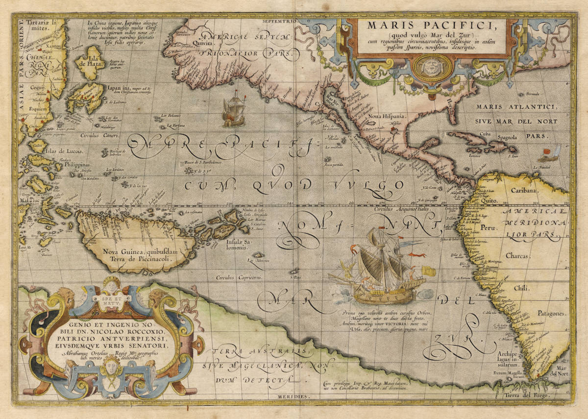
Description
Only the second copy known of the amended state of what is considered the best map of the Ortelius atlas. This final state is of exceptional rarity. No example recorded in America, Australia or Asia.
In this 1641 second state of the copperplate, the date "1589" has been removed from the lower left cartouche. Only one other example of this unobtainable second and final state is recorded, namely in the City Library of Antwerp (Belgium), the same city where the maps were printed at the time.
Ortelius' map of the Pacific illustrates the front cover of the ultimate carto-bibliography of maps of the Pacific (Thomas Suárez, Early Mapping of the Pacific).
Summary
The first published map devoted to the Pacific and the most important 16th century map to show the Spanish domination of the South Seas.
(Simon Dewez)
One of the most important maps that appeared in the Ortelius atlases, this was the first printed map to be devoted to the Pacific Ocean.
(Philip Burden)
This map is a titan in the history of cartography for its status as the first stand-alone map of the world’s largest ocean. It is also visually engaging and full of interesting geographic details revealing much about late-sixteenth century cartographic innovation.
(Alex Clausen)
This first printed map of the Pacific is of fundamental cartographical importance.
(Marcel van den Broecke)
Descriptions from the literature
The Mapping of North America - MARIS PACIFICI, Antwerp 1589 [90]
From: Theatrum Orbis Terrarum. Additamentum IV.
One of the most important maps that appeared in the Ortelius atlases, this was the first printed map to be devoted to the Pacific Ocean, the discovery of which is remembered by the depiction, with legend, of Ferdinand Magellan's ship the 'Victoria'. It was engraved at a time of increasing activity in the Pacific with the English having recently begun raiding the Spanish galleons carrying the gold of Peru up the coast to the Isthmus, as well as those making the arduous journey across from the Philippines to Mexico.
Ortelius worked closely with Frans Hogenberg and the Pacific cartography is derived largely from the latter's map published earlier in the year. An extensive study by Richard Casten and Thomas Suárez has recently been published on the sequence of three maps ascribed or dated to this year by Hogenberg, Mazza and Ortelius. Depicting the Pacific alone it does not include much inland detail from the west coast of the Americas. North America is largely obscured by the decorative title cartouche. This does, however, enable it to introduce some detail of the East Indies.
A notable difference between this and the Hogenberg is the introduction of a considerably narrower and more correct North America at the lattitude of the Tropic of Cancer. This had probably come to light through the increased exploration of the Spanish to the west of Mexico City and along that coastline. It, however, erroneously extends the longitudinal distance of the west coast of North America. The head of the Gulf of California is also depicted in a new form, with the R. Grande being introduced for the first time. This error is seen in many later maps and derives from the journey of Antonio de Espejo. It also names both North and South America; both the Hogenberg and the Mazza only name the North. This had first appeared on the Mercator world map of 1538, but from this date it was to be used regularly.
Being one of Ortelius' most desirable maps combined with the fact that it was not issued in the atlas until 1590, it is not as available as the various versions of his map of America. It was first published in his Additamentum IV in 1590 and was then included in future editions of the Theatrum starting with the Latin of 1591. There is an apocryphal Latin edition, mentioned by Sabin, of 1589, which by the description of the contents probably would not have included this map. There may have been an earlier proof state as there are signs of erasure to the left of the large ship in the Pacific. Although both the world and the America, by Ortelius, are known in a second state with the addition of the Strait of Le Maire in South America, there are no known examples of this map with such an alteration.
Despite this a second state is known in a sole example, this has had the date erased from the cartouche lower left. With Spanish text on the reverse it dates from post-1612.
In 1600 the copperplates for the Theatrum atlas passed into the possession of the printer and publisher Jan Baptist Vrients who issued all of the editions to 1612. In that final year they were bought by the brothers Jan and Balthasar Moretus who inherited the famous Plantin press. In 1624 they published an edition of Ortelius' Parergon, and in 1628 documents from the Plantin Museum archives show that they paid considerable amounts of money to both Arnold van Langeren and Ferdinand Arsenius to update a number of the plates. However, no later edition than 1612 had been located until recently when examples of what was thought to be the 1612 Spanish edition were found to contain maps with dates as late as 1640.
(Philip Burden map 74 and map 64)
The Printed World - ORTELIUS, Abraham - 1589 MARIS PACIFICI
Quod Vulgo Mar Del Zur cum regionibus circumiaccentibus ... novissima descriptio ... 1589.
First published in the Additamentum IV of Theatrum Orbis Terrarum, 1590 Antwerp.
The first published map devoted to the Pacific and the most important 16th century map to show the Spanish domination of the South Seas.
Abraham Ortelius first published his magnificent Theatrum Orbis Terrarum atlas in 1570. It was regarded as the first ‘modern’ atlas, as all the maps were engraved with a similar format and the same size. Theatrum went through many editions and changes, with some maps being removed and others being added.
Maris Pacifici was one such map. Although the map was prepared in 1589, its first appearance in an Ortelius atlas was in 1590 after Ortelius issued an Additamentum IV.
This map is one of his most splendid and as it only appeared in editions of the Theatrum from 1590 onwards, is far rarer than many other maps from the atlas. In the first state the map is dated 1589 and according to Burden was based on the chart constructed the same year by Frans Hogenberg (Burden 72). Hogenberg in fact was responsible for constructing many of the maps in Ortelius' atlas. As a side note, Ortelius worked closely with Hogenberg on the latter's famous Civitates Orbis Terrarum published in 1572, which for the first time illustrated over five hundred European cities.
Maris Pacifici illustrates the lengths to which the Spanish had gone, in order to establish some control over any possible sea passage to the East Indies via South America. Their intentions are clearly depicted in the illustration (together with notation) of Ferdinand Magellan's flagship the Victoria entering the Pacific after having circumnavigated the globe. This was an active time for the Spanish who were now expanding their influence and exploration west of Mexico City.
Although on his world map Ortelius questions the island status of New Guinea, here he clearly depicts the country as an island. The Solomon Islands are charted not only too close to New Guinea, but also substantially larger than they are in reality. Terra Australis Incognita is clearly delineated as a coastline incorporating Tierra del Fuego and sloping up across the Pacific towards New Guinea.
Van den Broecke 12.1; Clancy Terra Australis illus. p.65; Burden 74, illus. p.94; Campbell Early Maps, pl.9; Landmarks of Mapmaking p.200; T.M.C. No.74, illus. p.6; Baynton-Williams Investing in Maps, illus. p.142; Walter Japan, map 116, col. illus.
(Simon Dewez, The Printed World)
Early Mapping of the Pacific - Pacific Ocean, Abraham Ortelius, 1589.
Dated (and presumably engraved in) 1589, this first printed map specifically devoted to the Pacific Ocean was first published in 1590. Only two years separated this from Ortelius's revision of his map of America, which included most of the Pacific because the west coast of New Guinea and the Strait of Anian were placed on the same longitude. Yet Ortelius now delineates New Guinea in a new fashion, omits Juan Fernandez, reworks the Spanish discoveries in Micronesia, and draws heavily from Spanish incursions north along the California coast to give new form to the American Northwest. Unlike Ortelius's map of America, however, the Maris Pacifici was not widely copied, a 1598 map by Metellus being the only unaltered published imitation.
(Thomas Suárez)
Collecting Antique Maps - Ortelius Maris Pacifici
The engraving date, of 1589, appears below the dedicatory cartouche of this beautiful map. The ocean is shown somewhat smaller than is actually the case and the west coast of America is shown in more detail than in any of Ortelius's other maps which show it. New Guinea is shown as a large island of definite shape and the great southern continent is also clearly marked. Japan, in two islands, appears in one of its most bizarre forms. Magellan's ship - the Victoria - occupies the southern Pacific and is accompanied by the quotation which translates:
It was I who first circled the World, my sails flying. You, Magellan, I led to your new found strait, by right am I called Victoria; mine are the sails and the wings, the prize and the glory, the struggle and the sea.
(Jonathan Potter p128)
Monumenta Cartographica Neerlandica - Volume III
For a long time it was supposed that the history of Ortelius' atlas of the world ended with the Spanish edition of 1612, and that the copperplates were not used any more. Already in Volume II of my Monumenta Cartographica Neerlandica I have referred to the copperplates for the maps of Ortelius, which were re-published, complete with alterations, by Theodoor Galle and his son Joannes. From archive material we know that in 1618 Balthasar Moretus made preparations for a reissue of the Theatrum: he paid rather high sums to the engravers Ferdinand Arsenius and Arnold Floris van Langren for the adaptation of the copperplates. The mathematician Godefridus Vendelinus was to write an explanatory text.
For reasons unknown this project was shelved. However, the recent discovery of a complete copy of the atlas [in the Antwerp City Library] proves that, in spite of this, an atlas of the world appeared in the 1640s, in which the plates were printed on the old Spanish text sheets of 1612.
(Günter Schilder)
Koeman's Atlantes Neerlandici - Volume III
Theatro d'el Orbe de la Tierra, Antwerpen: Plantin Press (Balthasar II Moretus), 1641
In 1612, Jan and Balthasar Moretus, owners of the Plantin Press, bought the copperplates and text sheets of Ortelius's Theatrum from the estate of Jan Baptist Vrients. In the same year they published a new Latin, Italian and Spanish edition. Since they only printed a new imprint on the title page the contents of these editions are identical to Vrients's 1608/09 editions.
For the Spanish edition, 19 copies with maps and 220 copies without maps were in Vrients's estate. In the 1642 inventory of Balthasar Moretus's estate there were 22 copies with maps and 160 without maps. In 1641 the maps for 25 copies were printed; 35 new copies were therefore printed in 1612 and following years. Copies printed after 1612 are recognizable because of some updated maps.
After the death of his brother Jan (1576-1618), Balthasar Moretus (1574-1641) became the owner of the Plantin Press and worked hard to publish a new edition of Ortelius's Theatrum. He began with the publication in 1624 of an enlarged edition of the Parergon, then updated the Theatrum maps by reworking the old plates and engraving some new ones, for which he hired Arnold Floris van Langren and Ferdinand Arsenius. In 1632 he even began printing the texts for the first sixteen maps. The negative comments about Van Langen's work by Balthasar's cousin, Theodorus Moretus, who studied mathematics in Prague, brought the project to an end.
At the end of his life, Balthasar seems to have had a new interest in the Theatrum and on 11 May 1641 Jan Galle was paid for printing 25 copies of each of the 138 plates for a Spanish edition. Balthasar Moretus died on 9 July 1641. In the 1642 inventory of his estate there were 22 copies of the Spanish Theatrum with the plates and another 160 copies of the Spanish text without the plates. The imprint and date on the title page had not been altered.
Upon the death of Balthasar Moretus his nephew, Balthasar II Moretus (1615-1674), the son of Jan Moretus, took over the business. It is likely that he was responsible for the printing of the new Spanish edition, which he presented a copy to the town of Antwerp, where it is still in the city's library (Antwerpen SB).
(Peter van der Krogt)
Transcriptions and translations of texts appearing on recto [the front] of Maris Pacifici
Marcel van den Broecke translated all texts on this map, as follows:
Title:
MARIS PACIFICI, | (quod vulgó Mar del Zur) | cum regionibus circumiacentibus, insulisque in eodem | passim sparsis, novissima descriptio.
[A very new description of the peaceful sea, commonly called South Sea with the regions lying around it, and its islands, scattered everywhere].
Bottom right:
Cum privilegiis Imp. & Reg. Maiestatum, | nec non Cancellariæ Brabantiæ, ad decennium.
[with privileges of the imperial and royal Majesties, as well as of the Brabant council, for a period of ten years].
Cartouche lower left:
SPE ET | METV. | GENIO ET INGENIO NO: | BILI DN. NICOLAO ROCCOXIO, | PATRICIO ANTVERPIENSI, | EIVSDEMQVE VRBIS SENATORI, | Abrahamus Ortelius Regiæ Mts. geographus | sub. merito dedicabat. | 1589.
[In hope and reverence. Through application and talent, Abraham Ortelius, geographer of his royal Majesty because of merit, has dedicated [this map] in 1589 to the honourable Lord Nicolaus Roccoxius, patrician of Antwerp, and senator of that city].
Text block below ship:
Prima ego velivovis ambivi cursibus Orbem, | Magellane novo te duce ducta freto. | Ambivi, meritoque vocor VICTORIA: sunt mî | Vela, alæ; precium, gloria: pugna mare.
[I was the first to sail around the world by means of sails, and carried you, Magellan, leader, first through the straits. I sailed around the world, therefore I am justly called Victoria [Victory], my sails were my wings, my prize was glory, my fight was with the sea].
Text block upper left near Japan:
In China regione, Iapania alijsque | insulis vicinis, messis multa Chris:|tianorum: quorum indies novæ co:|loniae ducuntur, patribus societatis | Iesu fidis operarijs.
[In the region of China, as also of Japan and the neighbouring isles, many have been won for the Christian faith by the fathers of the society of Jesus, going to the settlements in the new Indies, as a result of their efforts].
Text block lower left:
Nova Guinea, quibusdam | Terra de Piccinacoli.
[New Guinea, according to some the land of the Pinnacoli (Italian dialectical term for little people or dwarfs, from the Andrea Corsali's letters)].
Under the Great Wall of China
Murus quingentorum leucar.
[A wall of five hundred (Spanish) leagues.]
North of Japan
Isla de Plata.
[Island of Silver.]
With annotation
Argyra hec forte antiquorum.
[Perhaps the Argyra of the ancients.]
Next to Japan
Iapan Ins. nuper ad Fidem Christianam conversa.
[The island of Japan, recently converted to the Christian faith.]
In western Japan
Minas de plata.
[Silver mines.]
On the eastern entrance of Magellan's Strait
Arx quam rex Philip II, extrui curavit A°. 1582.
[A castle which king Philip II ordered to be built in 1582.]
(After Drake's intrusion in the Pacific, Philips II built a fortress at the entrance of the strait to prevent other nations from entering the Pacific. The project did not end well, most settlers perished of famine, the few survivors were rescued by Thomas Cavendish when he passed the Strait).
On the Southland
Terra Australis sive Magellanica, nondum detecta.
[The Southland or Magellanica, not yet uncovered.]
(Marcel van den Broecke Map 12)
Translation of the text on verso [the back] of the Maris Pacifici
This 1641 example has Spanish text on verso. For the different language editions, and over the years that the Theatrum was produced, the verso texts slightly vary and evolve. Here we reproduce the contemporary English text on verso of the 1606 English edition of the Maris Pacifici, which is very close to the text of the Spanish editions.
The verso texts of most Ortelius maps are of particular interest and significance because, for the maps appearing in his lifetime (so up to 1598), these are the texts that Ortelius himself wrote to accompany and describe his maps, and he includes the sources he uses, which was unusual at the time.
The peaceable or the South Sea, called by the Spaniards MAR DEL SUR.
This sea albeit vnknowen, yet was it not vnnamed by ancient writers: for Plinie calles it Eoum, and Orosius [calls it] Orientale, that is, The East Sea. Ptolemey falsly termes it SINVM MAGNVM, A great bay; whereas he should haue nam'd it MARE MAGNVM, A great sea. For of all the seas in the world it is the greatest and the widest. In Paulus Venetus [Marco Polo of Venice] it is described vnder the name of Mare Cin, (that is, as I interpret it out of Nubiensis Arabs, Bahci 'ltzni vel alkini, Mare Sinarum, The fea of China) and in Haithon Armenus (whom elswhere we more truly call Antonie Curchino) by the name of Mare Cathay. Well therefore might it be named by the ancient and middle-age writers; but neuer was it fully knowen and discouered, till Fernando Magellan a Portugale sailed thereupon. Seene it was indeed, and as it were saluted in the yeere 1513, by Vasco Nunnez, from the coast of Perú.
But Magellan in the yeere of our saluation 1520, hauing passed the streight by him found, and called after his owne name (which it hitherto retaineth, for every common Mariner calles it The Streight of Magellan) with an heroick and Herculean courage entred this sea, which vncertaine it is, whether any shippe before his had euer stemmed. For meditating a voyage to the isles of the Moluccos, whereunto the Portugals vsually failed from West to East; and intending to make thither a shorter cut from East to West, he came at length vnto them by this sea: in one of which isles called Machtan, he was slaine in a skırmısh.
The course of his voyage was this: Departing from Siuil [Sevilla] with fiue ships, whereof one being his owne, was called by a name of good presage Victoria, he came to the fortunate or Canary-isles,; then to the Gorgones or Hesperides, now termed The isles of Cape verde; and thence to the Streight abouenamed: which when he had found and past thorow, he enters into this sea; where with a fresh and prosperous gale hauing sailed vpon the maine 40. dayes together, and beholding nothing but sea on all sides, and still the sea; when he had crossed the South tropick he descried two small barren and vnhabited isles : where notwithstanding, because they found good fishing, they staied two dayes & then departed, calling them the Vnfortunate isles. Now, they are knowen by the name of Tuberones, and the isles of S.Peter. Then he proceeds on his nauigation, & in the space of 3. moneths and 20. dayes, hauing sailed ouer this vast Ocean 2400. leagues, he attained at length to the Æquinoctiall, and thence to the desired Moluccos. And because (as we have said) he had for the most part a prosperous & no tempestuous wind, he named this Pacificum or The peaceable sea, now called by the common Mariner, The South sea, or Mar del Sur. Those that have written of the New world, say, that this sea about thote vnfortunate isles, is most exceeding deepe, and that neere vnto the coast of Perú it yeeldeth pearles, and that there are in it 7449. isles, so that some in our times not vnfitly haue called the Western part thereof Archipelagus or A sea thicke set with isles: seeing this, like the Ægean sea (which is planted all ouer with the Cyclades, the Sporades, and many other islands, and is called in the Italian tongue Archipelago) is also with isles most notably replenished. In the bottome of this sea Francis Vlloa and Antonie Digafetta [Pigafetta] do report, that there growes a weed of 14. or 15. fathoms high within the water; and that it riseth out of the water to the height of some 4. or 5. fathom: so that sometimes you shall seeme not to saile thorow a sea, but rather thorow a greene medow. The place of Aristotle in his booke De Admirandis &c. doth not much disagree from this; where he writes of the Phœnicians which inhabited Gadyra [Cadiz], that when they had sailed a while without the pillars of Hercules, they arriued at certeine regions abounding with weeds and slime, which were ouerflowed with the tides of the sea. The very same affirmeth Iornandes in the beginning of his Getish [Gothic] history; where he writes, that none could saile thorow the Ocean, being impassable in regard of weeds or turfs, and for that cause vnknowen. Yea Plinie and Antigonus out of Megasthenes haue left recorded, that all the East Ocean growes full of woods. And that the sea neere Portugale should beare Okes laden with mast, Polybius reporteth in Athenans. Also, that the Bay-tree growes in the Red sea, the same authour affirmes vpon the credit of Pythagoras. Hereunto you may addetharof Theophrastus in his 4. booke of the history of Plants, cap.7.8.9. and the testimony of Ælianus, lib, 13.de Animal.cap.3. and Strabo, lib.16. and Plinie, lib.2.cap.103. lib.6.cap.22. and lib.13.cap.25. and Plutarch in his naturall questions concerning the face in the orbe of the Moone. All these are in some sort confirmed by Platoes fables or histories in his Timaus concerning the isle Atlantis; whose sea he affirmes to be vnnauigable by reason of the slime or oaze remaining of the same isles inundation.
But concerning the ship called La Victoria learne thus much: it is not sayd amisse: Bare names oft times things named doe resemble: Manifest it is by this ship, which vnder this happy name, the first voyage that euer she made, was the only ship that caried away the victory of sailing quite ouer the maine Ocean, for so many ages before. For departing from Spaine, by the Streight of Magellan, to the Moluccos, thence hauing doubled the Cape of Buona Esperança, and returned, whence she first put forth, she was the first of all ships and in all ages, that euer circumpassed the whole earth. The same ship made out of Spaine a second voyage as farre as S. Domingo and home againe. Thither also she made a third voyage; but in her returne she was quite lost ; neither was it euer knowen what became of her. Antiquity would haue thought she had beene taken vp into the skies, and placed among the Constellations, like another Argo. Nor had this propheticall verse of the peerelesse Poet beene vnfitly alleged in her commendation. Then comes another Tiphys, another gold-fleeced Argo. Let Plinie now cease to maruell, that out of a small hemp seed should grow that, which was of force to cary vp and downe the globe of [his] earth. We in our age haue seene with the very same thing this world of ours, much greater than his nauigated roundabout. Ours, I say: which that you may more perfectly vnderstand, do but compare the first Table of our Theatre [the modern map of the world in the Theatrum atlas] with the first of our Parergon or By-worke [the world map of antiquity in the Parergon atlas], and you shall see the difference.
And here, I suppose, I shall not bestow my labour altogether in vaine, by adding certaine particulars not commonly knowen, concerning the first discouery hereof. Which by all our late Writers is not vnworthily ascribed to Christopher Columbus. For in the yere 1492, he was the first man that laid it open, & made it knowen, and communicated the vse and benefit thereof to the Christian world. Howbeit I finde, that the North part of America (which lieth neerest vnto Europe, and to some of our European isles, namely, Groenland, Island, and Frisland; and is called Estotiland) was long since discouered by certaine Frislandish fishers, driuen by tempest vpon that coast: and afterward about the yere 1390, that it was reuisited anew by Antonie Zeno, a gentleman of Venice: and that by the authority of Zichmi, then King of the said isle of Frisland, a Prince in those times very valiant, and ouer all that sea, for his warres and victories most renowmed. Concerning this his expedition there are extant in Italian certaine Collections or briefe extracts drawen by Francis Marcolino out of the letters of Nicolas and Antonie Zeno gentlemen of Venice, who liued in these parts. Out of which Collections I adde this that followes touching the description of this region. Estotiland (he saith) abounds with all things necessary for mankind. In the mids therof stands an exceeding high mountaine, from whence issue foure riuers that water the whole country. The inhabitants are witty, and most expert in all kind of handicrafts. A language and letters they haue peculiar to themselues. Howbeit in this Kings Library there are certeine Latine books, no whit vnderstood by them, which might perhaps before that time be there left by some of their European neighbors that had traffique with them. They have all kinds of mettall, but specially gold, wherewith they mightily abound. They exercise trade of merchandize with the people of Groenland; from whence they fetch hides, pitch, & brimstone. The inhabitants say, that towards the South there are countries rich of gold,and replenisht with inhabitants. There are also many & great woods; out of which they haue matter for the building of their ships and cities; whereof and of fortresses there are great numbers. Of the loadstones vse in nauigation they are vtterly ignorant. They also make mention of Drogeo, a region toward the South inhabited by Canibals, and such as are delighted to eat mans flesh; for want whereof, they liue with fishing, which they very much vse. Beyond this there are large countries and another New world; but the inhabitants are barbarous, and go naked: howbeit against the cold of Winter they arme themselues with beasts skinnes. These haue no kind of mettall: they live by hunting. For weapons they vse long and sharp-pointed staues and bowes. They make warres one vpon another. Gouernours they haue, and lawes wherto they yeeld obedience. Southward of this place they liue in a more temperate climate, hauing cities and idol-temples wherin they sacrifice living men whose flesh they afterward deuoure. These haue the vse of gold and silver.
Thus much concerning this tract of land, out of the foresaid collections or extracts; wherein this also is worthy the obseruation, that euen then our European Pilots by meanes of the loaditone sailed those seas. For I am of opinion that there is not to be found in any history a more ancient testimony touching the forefayd vse of this stone. And these things I was the willinger to adioyne to this Table [Map], because I see none of them that haue written the histories of the world so much as once mention this matter.
But concerning the loadstone or sea-compasse you are to vnderstand, that the first inuentour therof was Iohn Goia a citizen of Melfi [Amalfi], whom Alexander Sardus in his booke De inuentoribus rerum [about matters of inventions] calleth Flauius Campanus. For so write the Italians, and so much is confirmed by Antonie Panormitanus in this one verse of his: First Melfi Sailors taught, the loadstone how to use, and that in the yere of our Sauior 1300. This Melfi called Amalphis in Latine, is a towne situate vpon the sea-shore of Lucania. Goropius ascribes the finding out of this secret to our Danes or Dutchmen; being persuaded hereunto, because the names of the 32. winds written vpon the compasse, are by all Pilots and Mariners, be they French, Spaniards, or of what nation soeuer, expressed in the Dutch tongue: which I confesse to be true, if you except the Italians only: for they both write and speake of these winds in their owne mother-language. Howbeit seeing all our nauigatours of Europe, be they Spaniards, French, English or Dutch, do expresse them in our language, I am verily of opinion, that as it was first found and vsed by the Amalfitans or Italians especially within their owne Mediterran sea: so was the knowledge therof from them deriued vnto our Netherlanders and most of all to those of Bruges; whose city at that time (before all traffque was reduced to Antwerpe) was a famous mart-towne, and frequented by Italians, especially of Venice as the foresaid Zeni report: and according to the testimony of Peter Quirini, Christopher Fiorouanti, and Nicolas Michele, who in this our Ocean suffered that horrible shipwracke which we reade of in the Italian volumes: witnesse also Lewis Cadamosta, who in his Epistles written about the yeere 1454, affirmes this city of Bruges to be a Mart inferiour to none else in all the North parts of the world. Wherefore, that the citizens of Bruges receiued the vse of the sea-compasse from the Italians, and out of Italian translated the names of the winds into their owne language, and that from them the other nations before mentioned borrowed this knowledge, I see not well, how it may be denied. Of the nature and admirable vertue of the loadstone you may reade many notable things in Liuius Sanutus his description of Africa, printed in Italian at Venice.
The isles of Salomon, which in this table [map] you see described about Noua Guinea, were not long since discouered by Oliuer Mendanio, after he had conducted his fleet out of the part [port] of Lima in Perú, & had sailed ouer this huge Ocean: as I find recorded in Iosephus Acosta his 1.book & 17.chapter De natura noui orbis [On the Nature of the New World].
(Abraham Ortelius, descriptive text on verso of his map of the Pacific)
Abraham Ortelius (1527-1598)
Abraham Ortelius is the most famous and most collected of all early cartographers. In 1570 he published the first comprehensive collection of maps of all parts of the world, the Theatrum Orbis Terrarum ("Theatre of the World"), the first modern atlas as we know it.
"Abraham Ortel, better known as Ortelius, was born in Antwerp and after studying Greek, Latin and mathematics set up business there with his sister, as a book dealer and ‘painter of maps'. Traveling widely, especially to the great book fairs, his business prospered and he established contacts with the literati in many lands. On one such visit to England, possibly seeking temporary refuge from religious persecution, he met William Camden whom he is said to have encouraged in the production of the Britannia.
A turning point in his career was reached in 1564 with the publication of a World Map in eight sheets of which only one copy is known: other individual maps followed and then – at the suggestion of a friend - he gathered together a collection of maps from contacts among European cartographers and had them engraved in uniform size and issued in 1570 as the Theatrum Orbis Terrarum (Atlas of the Whole World). Although Lafreri and others in Italy had published collections of ‘modern' maps in book form in earlier years, the Theatrum was the first uniformly sized, systematic collection of maps and hence can be called the first atlas, although that term itself was not used until twenty years later by Mercator.
The Theatrum, with most of its maps elegantly engraved by Frans Hogenberg, was an instant success and appeared in numerous editions in different languages including addenda issued from time to time incorporating the latest contemporary knowledge and discoveries. The final edition appeared in 1612. Unlike many of his contemporaries Ortelius noted his sources of information and in the first edition acknowledgement was made to eighty-seven different cartographers.
Apart from the modern maps in his major atlas, Ortelius himself compiled a series of historical maps known as the Parergon Theatri which appeared from 1579 onwards, sometimes as a separate publication and sometimes incorporated in the Theatrum."
(Moreland and Bannister)
"The maker of the ‘first atlas', the Theatrum Orbis Terrarum (1570), started his career as a colorist of maps. Later, he became a seller of books, prints and maps. His scientific and collecting interests developed in harmony with those of a merchant. He was first and foremost a historian. Geography for him was the ‘eye of history', which may explain why, in addition to coins and historical objects, he also collected maps. On the basis of his extensive travels through Europe and with the help of his international circle of friends, Ortelius was able to build a collection of the most up-to-date maps available.
The unique position held by Ortelius's Theatrum in the history of cartography is to be attributed primarily to its qualification as ‘the world's first regularly produced atlas.' Its great commercial success enabled it to make a great contribution to ‘geographical culture' throughout Europe at the end of the sixteenth century. Shape and contents set the standard for later atlases, when the centre of the map trade moved from Antwerp to Amsterdam. The characteristic feature of the Theatrum is that it consists of two elements, text and maps. Another important aspect is that it was the first undertaking of its kind to reduce the best available maps to a uniform format. To that end, maps of various formats and styles had to be generalized just like the modern atlas publisher of today would do. In selecting maps for his compilation, Ortelius was guided by his critical spirit and his encyclopaedic knowledge of maps. But Ortelius did more than the present atlas makers: he mentioned the names of the authors of the original maps and added the names of many other cartographers and geographers to his list. This ‘catalogus auctorum tabularum geographicum,' printed in the Theatrum, is one of the major peculiarities of the atlas. Ortelius and his successors kept his list of map authors up-to-date. In the first edition of 1570 the list included 87 names. In the posthumous edition of 1603, it contained 183 names.
Abraham Ortelius himself drew all his maps in manuscript before passing them to the engravers. In the preface to the Theatrum he stated that all the plates were engraved by Frans Hogenberg, who probably was assisted by Ambrosius and Ferdinand Arsenius (= Aertsen). The first edition of the Theatrum is dated 20 May 1570 and includes 53 maps.
The Theatrum was printed at Ortelius's expense first by Gielis Coppens van Diest, an Antwerp printer who had experience with printing cosmographical works. From 1539 onwards, Van Diest had printed various editions of Apianus's Cosmographia, edited by Gemma Frisius, and in 1552 he printed Honterus's Rudimentorum Cosmograhicorum... Libri IIII. Gielis Coppens van Diest was succeeded as printer of the Theatrum in 1573 by his son Anthonis, who in turn was followed by Gillis van den Rade, who printed the 1575 edition. From 1579 onwards Christoffel Plantin printed the Theatrum, still at Ortelius's own expense. Plantin and later his successors continued printing the work until Ortelius's heirs sold the copperplates and the publication rights in 1601 to Jan Baptist Vrients, who added some new maps. After 1612, the year of Vrients's death, the copperplates passed to the Moretus brothers, the successors of Christoffel Plantin.
The editions of the Theatrum may be subdivided into five groups on the basis of the number of maps. The first group contains 53 maps, 18 maps were added. The second group has 70 maps (one of the 18 new maps replaced a previous one). In 1579 another expansion was issued with 23 maps. Some maps replaced older ones, so as of that date the Theatrum contained 112. In 1590 a fourth addition followed with 22 maps. The editions then had 134 maps. A final, fifth expansion with 17 maps followed in 1595, bringing the total to 151."
(Peter van der Krogt, Atlantes Neerlandici New Edition, Volume III)