Leen Helmink Antique Maps & Atlases
www.helmink.com
van Keulen
Het Inkomen van de Haven van Aimoey Van Rio Chinchew af tot de ERASMUS Baay ...
Certificate of Authentication and Description
This is to certify that the item illustrated and described below is a genuine antique
map, print or book that was first produced and published in 1753, today 273 years ago.
July 13, 2026
Cartographer(s)
van Keulen
First Published
Amsterdam, 1753
This edition
1753 first and only edition
Size
47.7 x 29.2 cms
Technique
Copper engraving
Stock number
18962
Condition
pristine
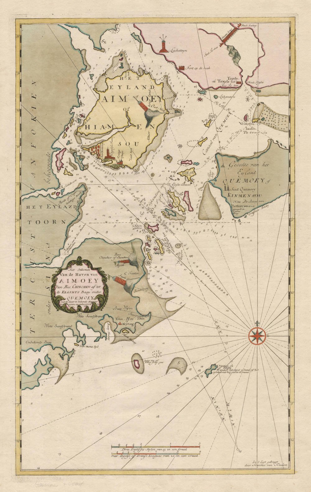
Description
A seminal sea chart of Amoy (Xiamen) and Quemoy (Kinmen), and the first accurate and detailed mapping of the area.
The chart shows very detailed depth soundings in fathoms, safe anchorages, as well as many landmarks for safe navigating these waters.
Xiamen island used to be known by westerners as Amoy, while Kinmen island was known as Quemoy.
Xiamen was a busy seaport starting in the Song Dynasty. Later, It became an outpost and refuge for Ming loyalists fighting the Manchu Qing Dynasty. Koxinga, son of a merchant pirate set up his anti-Qing base in the area and today a large statue in his honor looks out over the harbor from Gulang Yu island.
Portuguese missionaries arrived in the 16th century but were quickly kicked out. Later British and Dutch traders stopped in until the port was closed to trade in the 18th century. It wasn't until the First Opium War and the Treaty of Nanking in 1842 that Xiamen was re-opened to the outside when it was established as one of the Treaty Ports open to foreign tradesmen.
At that time most of the tea that left China was shipped out of Xiamen. Gulang Yu, a small island off of Xiamen, was allotted to the foreigners and the whole place became a foreign enclave. Most of the original architecture remains.
Zeefakkel Part VI: the Secret Atlas of the VOC
The chart is from an exceptionally rare sea atlas by Johannes (II) van Keulen, the Zee-Fakkel Part VI, issued in 1753, the so-called secret atlas of the Dutch East India Company, of this atlas only a few copies have survived.
For many regions in Asia and Africa, the printed maps from this atlas are the first, the best and the only accurate early maps.
These maps are never in the market, and they are beyond doubt the non plus ultra of printed maps of the East Indies and the Indian Ocean.
For two centuries, from 1602 to 1799, the Dutch East India Company (the VOC) ruled the waters of Asia and Africa. Accurate charting of these waters was essential for successful and safe navigation.
The VOC had their own map making office. During the first 150 years, only secret manuscript charts were used, to minimize the risk of spreading the knowledge to competitors. But from 1753 on, a printed atlas was used, the van Keulen Zee-Fakkel Part VI, with printed charts to navigate the waters from South Africa to Japan.
At that time, there was a variety of reasons for printing the VOC maps, instead of working with manuscript charts:
First, in the course of 150 years the knowledge of these waters had leaked out to other European nations and secrecy was of less importance.
Second, printed maps were more accurate and less prone to errors than manuscript copies.
Third, loose maps were impractical and sometimes lost despite the strict policies of use.
Fourth, in the course of 150 years the knowledge of these waters had leaked out to other European nations and secrecy was of less importance.
And last, but not least, printed charts were cheaper to reproduce than manuscript charts.
The atlas is known as the secret atlas of the East India company, because it was not sold to third parties and only used on board of VOC ships. For this reason it is extremely rare, and only few have survived. Further, the number if charts in the atlas is often limited because ships that did not sail to India / Ceylon or China / Formosa / Japan were given versions of the atlas that did not contain the charts of these areas, making many of the maps even rarer.
Condition
First and only 1753 edition. Printed on thick double layered paper, to survive the humid and salt air circumstances at sea. Very wide margins all around. A strong and even imprint of the copperplate. This example in vibrant contemporary colour, applied by the van Keulen publishing house. Original colour is rare for early sea charts, because it was only done on special request by wealthy armchair travelers or high ranking officials or royals. Pristine collector's condition for an unobtainable important chart.
Johannes van Keulen (1654-1711)
Gerard van Keulen (son) (1678-c.1727)
Johannes van Keulen II (grandson) (active 1726-1755)
The Dutch produced a remarkable number of enterprising and prolific map and chart makers but not even the Blaeu and Jansson establishments could rival the vigour of the van Keulen family whose business was founded in 1680 and continued under their name until 1823 and in other names until 1885 when it was from wound up and the stock dispersed at auction.
Throughout the history of the family, the widows several of the van Keulens played a major part, after their husbands' deaths, in maintaining the continuity of the business. The firm was founded by Johannes van Keulen who was registered as a bookseller in Amsterdam in 1678. In 1680 he published the first part of his 'Zee Atlas' which, over the years, was expanded to 5 volumes and continued in one form or another until 1734. More ambitious and with a far longer and more complicated life was his book of sea charts, the 'Zee-Fakkel', first published in 1681–82, which was still being printed round the year 1800. A major influence in the development of the firm was the acquisition in 1693 of the stock of a rival map publisher, Hendrik Doncker.
Although the firm was founded by Johannes van Keulen, he was primarily a publisher; it was his son, Gerard, a talented engraver, mathematician, Hydrographer to the East India Company, who became mainspring of the business which not only published charts but also books on every aspect of geograpy, navigation and nautical matters,
(Moreland and Bannister)
It was grandson Johannes van Keulen (II) who in 1753 produced Volume VI of the Zee-Fakkel for the VOC East Indiamen, containing printed charts for the navigation covering the waters from the Cape of Good Hope to Nagasaki . The atlas was not commercially sold and only for use on board of VOC ships, therefore it is also refered to as the 'secret atlas' odf the VOC. The engraving quality and craftmanship surpasses that of all earlier printed sea charts.
Sea charts from the secret atlas are among the rarest and most desirable sea charts for collectors.