Leen Helmink Antique Maps & Atlases
www.helmink.com
Wright / Visscher
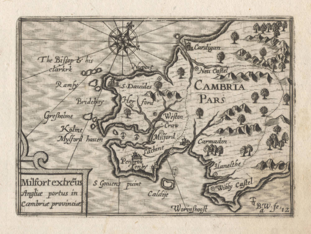
Cambria Pars - Milfort extremus Angliae portus in Cambriae provinciae.
Certificate of Authentication and Description
This is to certify that the item illustrated and described below is a genuine antique
map, print or book that was first produced and published in 1649, today 377 years ago.
June 2, 2026
Cartographer(s)
Wright / Visscher
First Published
Amsterdam, 1649
This edition
1649 first and only edition
Size
8.5 x 12.5 cms
Technique
Copper engraving
Stock number
18954
Condition
excellent
Description
Milfort extremus | Angliæ portus in Cambriæ provinciæ / B.W. fe..
8.5 x 12 cm. Bottom right ‘a.12'. Chart of Wales and the port of Milfort.Unobtainable map/chart of Wales, engraved ca 1599 by Benjamin Wright for Amsterdam publisher Cornelis Claesz, but not published at that time. This map only occurs in Claes Janszoon Visscher's exceptionally rare Tabularum Geographicarum Contractarum of 1649. It is the first time we see this map appear in the market.
The map was issued in 1649 in the Tabularum Geographicarum Contractarum or Atlas Contractus by the distinguished Claes Janszoon Visscher (1587-1652). In this pocket atlas, all maps appear with a signature mark in the lower right. This particular map has a.12. Such numbers are intended for the bookbinder, to instruct where and in what order to bind the maps into the atlas. Signature marks were generally printed in typeset on the verso of maps, in addition to the page number. The reason is that the bookbinder works in terms of sections or gatherings, groups of paper sheets that need to be folded, and not in terms of page numbers. Because Visscher did not add any printed text to this atlas, leaving the verso of the maps blank, he chose to engrave the signature marks in the lower right corners of the maps.
In 1649 Visscher had come into possession of the original Langenes plates first used in 1598, which were originally owned by the Amsterdam publisher Cornelis Claesz, where Visscher had worked as a young apprentice. H. Laurentsz re-printed the atlas in 1609 and 1612, and the whereabouts of those copperplates is uncertain until they again appear in 1649. Apart from the old Langenes copperplates, Visscher adds a few new maps by himself, as well as a few unrecorded maps that must have been made around 1598-1599 by Benjamin Wright when he (and Claes Janszoon Visscher) worked for Claesz.
The atlas is so rare that most of the maps in this final state are lacking in many important collections. Only 3 atlas copies are listed on WorldCat: British Library seems to be complete, State Library Victoria (Australia) almost complete, University of Michigan, 80 maps only.
Claes Janszoon Visscher was already at a respectable age when he issued the Atlas Contractus, but he knew the fifty years old maps by Langenes very well, because at a young age he had worked as an apprentice for Cornelis Claesz (c.1551-1609), who had been the stimulator and driving force of Dutch cartography, and who had been the publisher of the Langenes atlas.
It is possible that Visscher had already acquired the Langenes copperplates at the famous 1610 auction of the stock of books, maps, prints and copperplates of his former employer Cornelis Claesz. Never before had the Dutch Republic witnessed an auction of books and prints and copperplates of comparable scale.
According to Peter van der Krogt (New Koeman Volume III), no more than 8 copies of the atlas are known, of which only 6 are complete.
An unknown atlas project, engraved by Benjamin Wright
There are clear indications that around 1600 Cornelis Claesz was working not only on the miniature editions of Caert-Thresoor and the British Isles but also on another pocket atlas. This atlas was intended to show the coastlines, the mouths of the rivers, and the trading settlements that were important to Dutch merchants. At the same time, it was also meant to give information on the results of the voyages of discovery that the Dutch had made. Benjamin Wright carried out the task of engraving the maps from 1599 to 1602. These maps were not based on original work but were copies of existing maps and prints. For example, sections were taken from maps in Waghenaer's Thresoor (1592), which Claesz published from 1596 on. However, a selection was also made of maps and prints from journals of Dutch voyages that took place around 1600, material that Claesz had published in various languages.
It is not known why, in the end, the plans for this atlas were not carried out and the work was not completed. There are no explicit references to this project in Claesz's Const ende Caert-Register (1609). However, the fact that tens of copperplates had already been engraved in the time of Cornelis Claesz is substantiated by the existence of a miniature atlas that was published fifty years later. In 1649, Claes Jansz Visscher published a pocket atlas that is now extremely rare: N.J. Visscheri Tabularum Geographicarum Contractarum Libri Quatuor Denuò Recogniti. For this work, Visscher mainly used the copperplates that had been used in the various editions of the CaertThresoor, supplemented by new maps. But next to these, they also contain prints of maps that had been engraved by Benjamin Wright and that had not been used for the Caert-Thresoor.
Visscher's edition of 1649 gives grounds to try to reconstruct Cornelis Claesz's original plan for a separate pocket atlas. In that attempt, the sources used by the engraver Benjamin Wright should be traced as far as feasible. Though Wright was not an innovative engraver, he was a highly skilled craftsman who engraved numerous maps and prints for Cornelis Claesz in the years around 1600. After his Amsterdam period, he moved on to Italy, where he engraved mainly for Magini.
(Schilder)
References:
van der Krogt Koeman's Atlantes Neerlandici, Volume III, map 8150:341:54.
Schilder, Monumenta Cartographica Neerlandica, Volume VII, pp 484-488.
Condition
Paper color off-white/ivory with no restorations or imperfections. Wide margins all around. A dark and even impression of the copperplate, no sign of plate wear, especially for a copperplate that was over 50 years old when this imprint was made. On the contrary, the scratched support lines for the toponyms prove that these are first impressions from the plates, supporting Schilder's hypothesis that Wright was working on a miniature atlas project that was abandoned for unknown reasons. Blank on verso as called for. Excellent collector's condition.
Benjamin Wright (1575-1613)
London, Amsterdam, Bologna and Rome.
Engraver and copperplate printer. Engraved a pair of celestial and terrestrial charts to illustrate John Blagrave, “Astrolabium uranicum generale" 1596;
Beschrijvinghe der zeecusten van Barbarielal tusken de straet van Gijbraltar ende caep de Cantin for Lucas Jansz. Waghenaer, “Thresoor der zee-vaert" 1596;
maps of Java, Sumatra, Madagascar and St. Helena for “Caert-thresoor, inhoudende de taflen des gantsche werelts landen” 1599, published by Cornelis Claesz of Amsterdam;
Gabriel Tatton, Nova et rece terraum et regnorum Californiae, Novae Hispaiae Californiae. Novae Hispaiae, Mexicanae, et Peruviae 1600;
Gabriel Tatton, Maris Pacifici quod Mar del Zur 1600; Hispaniae nova describtio 1600; Tabula geographica provinciarum Brabantiæ, Geldriæ comitatus, Sutphaniæ, Traiectini, Transilvaniæ, Drentiæ, Twentiæ, Hollandiæ, et Frisiæ; una cum præterlabentium fluviorum delineation 1600. for Cornelis Claesz;
Waerachtige af conterfeytinge der vermaẽr riviere van Londen, anders genaempt die Tamesis for Lucas Jansz. Waghenaer,
“Thresorie ou cabinet de la route marinesque" 1601;
Beschrijvinghe der landen ende zee-custen van Eembderlandt and eleven other charts for Lucas Jansz. Waghenaer, "Thresoor der zeevaert" 1602;
fourteen charts for Lucas Jansz. Waghenaer, "Den groten dobbelden nieuwen spieghel der zeevaert" 1603, again for Claesz;
a further thirty maps of the same size and style, including Alata castra Scotia regia urbs et metrolis vulgó Edimburgum ca. 1603 and Topographia insulæ Huenæ in celebri porthmo regna Daniæ were evidently engraved for Claesz at this time, but are extant only in Claes Jansz. Visscher, “Tabularum geographicarum contractarum libri quatuor denuo recogniti" 1649;
Italia nuova da Gio Antonio Magini 1608;
eleven maps for Magini's “Italia data in luce” 1620, the maps engraved somewhat earlier;
seven maps for Johann Isaac Pontanus, “Rerum et urbis Amstelodamensium historia” 1611, for Jodocus Hondius 1, again engraved at an earlier date, etc.
Said to have been born in 1575, and perhaps to be identified with the Benjamin Wright made free of the Goldsmiths' Company by patrimony 17 Mar 1597. Heawood suggested that the map Florentissimoru[m] Enorum Angliæ et Hiberniæ accurata descriptio veteribus et recentioribus nominibus illustrata 1594 might be by Wright, but Wright himself referred to his The armes of all the cheif corporations of England 1596 as the "first fruit of his labours”. He was working in Amsterdam by 1602 and probably for some years earlier, referred to in that year as an "Engelsch plaetsnyder woonende tot Amstelredam" [English copperplate cutter living in Amsterdam]. He subsequently worked in Bologna 1607-1608 and later Rome for the Italian publisher Giovanni Antonio Magini, who must have greatly valued Wright's work to have borne with so tiresome a collaborator, irregular in life and given to drink, for twice he had to release plates which Wright had pawned in Rome. Though other engravers known to have worked on Magini's “Atlas” ... it is surprising that no plates are signed but those bearing Wright's name” (Hind). John Evelyn bracketed Wright with Thomas Cecill as "little inferior to any we have enumerated for the excellency of their burins and their happy design”.
At the Hartshorne in Paternoster Row 1596, Amsterdam 1602, Bologna 1607-1608, Rome 1608-1613.
BBTI, BM. Burden (1996). COPAC. Goldsmiths. Griffiths. GL. Hind. Koeman. Shirley (2001). STC. Taylor (1954). Tooley.
(Worms and Baynton Williams)
Literature:
Laurence Worms and Ashley Baynton Williams, British Map Engravers, London, Rare Book Society, 2011, pp 735-736.
Valerie Scott, Tooley's Dictioonary of Mapmakers - Revised Edition Q-Z, Early World Press, 2004.
A.M. Hind, Engraving in England in the Sixteenth and Seventeenth Centuries. I, The Tudor Period, Cambridge University Press, 1952, pp 212-213.
Claes Janszoon Visscher 1587-1652
Nicolaes Visscher I (son) 1618–1679
Nicolaes Visscher II (grandson) 1649-1702
Elisabeth Visscher (widow of N. Visscher II)
Claes Jansz(oon) Visscher: A Cartographic Luminary of the Dutch Golden Age
Early Life and Apprenticeship
Claes Jansz(oon) Visscher, born on April 23, 1587, in Amsterdam, was a quintessential figure of the Dutch Golden Age, a period renowned for its flourishing culture, science, and trade. Coming from a family of artists, his father, Jan Claesz Visscher, was an engraver who likely introduced Claes to the intricacies of the craft from a young age. This early exposure to engraving and drawing under his father's mentorship laid the groundwork for Claes's illustrious career in cartography.
Claes's education in the arts was typical of the time, where young artists would apprentice under a master, learning through observation and practice. Given his family background, Claes would have had an intimate knowledge of the techniques of engraving, which was a critical skill for mapmaking during the period.
Career and Contributions
Claes Jansz Visscher's career took off in the early 17th century, a time when Amsterdam was becoming the epicenter of global trade and, consequently, cartography. Maps were not just navigational tools but also symbols of power and knowledge, reflecting the wealth and curiosity of the Dutch Republic. Visscher's maps were distinguished by their artistic embellishments, including coats of arms, allegorical figures, and scenes from mythology or daily life, which made them as much works of art as they were functional maps.
Claes Jansz. Visscher apprenticed with Cornelis Claesz., the foremost publisher of maps and pilot guides at the time. This collaboration is evidenced by several works, including maps and engravings, where Visscher's contributions are acknowledged. Visscher's apprenticeship or close working relationship with publishers like Cornelis Claesz was pivotal in shaping his career in mapmaking and engraving.
One of his early notable works was a map of the British Isles in 1616, which demonstrated his capability to blend geographical accuracy with artistic flair. This map, like many of his others, was highly sought after by collectors and navigators alike. His maps often included detailed town views, which were in vogue, providing a visual record of cities and landscapes as they appeared at the time.
The "Orbis Terrarum Typus" and Other Works
In 1638, Visscher produced one of his most celebrated works, the "Orbis Terrarum Typus," which was engraved by Pieter Goos. This map was notable for its hemispheric presentation of the world, reflecting the latest geographical knowledge while maintaining Visscher's signature decorative style.
Visscher's work also included significant contributions to regional cartography. His maps of the Netherlands were particularly detailed, reflecting the importance of accurate maps for trade and defense in a region crisscrossed by waterways and crisscrossed with political boundaries.
Legacy and Influence
Claes Jansz Visscher's influence on cartography was profound. His maps were not only used for navigation but also as status symbols, adorning the walls of the wealthy and educated. His style, characterized by detailed engraving and artistic embellishments, set a standard that influenced other cartographers of his time and beyond.
Visscher's business acumen was also noteworthy. He was not just a mapmaker but also a publisher who understood the market for cartographic products. His publications included atlases and individual maps, which were often sold in sets or bound together by purchasers, indicating a savvy approach to the market's demands.
Death and Continuation of Legacy
Claes Jansz Visscher died on June 19, 1652, in Amsterdam. His son, Nicolaes Claesz Visscher, continued the family business, maintaining the high standards set by his father. The Visscher name remained synonymous with quality in cartography for several generations, illustrating the lasting impact of Claes's work.
Conclusion
Claes Jansz Visscher's biography is not just about the life of a mapmaker but is emblematic of the Dutch Golden Age's spirit of exploration, artistry, and commerce. His maps were instruments of discovery, tools for governance, and canvases for artistic expression, making him one of the most influential cartographers of his era. Through his work, Visscher captured the world as it was known, leaving a legacy that continues to be admired for its blend of beauty and precision.
Antique Maps - A Collector's Guide
For nearly a century the members of the Visscher family were important art dealers and map publishers in Amsterdam. The founder of the business, Claes Janszoon Visscher, had premises near to those of Pieter van den Keere and Jodocus Hondius whose pupil he may have been.
From about 1620 he designed a number of individual maps, including one of the British Isles, but his first atlas consisted of maps printed from plates bought from van den Keere and issued as they stood with some additions of his own, including historical scenes of battles and sieges for which he had a high reputation.
Some maps bear the latinized form of the family name: Piscator. After Visscher's death his son and grandson, both of the same name, issued a considerable number of atlases, constantly revised and brought up to date but most of them lacking an index and with varying contents.
The widow of Nicholaes Visscher II carried on the business until it finally passed into the hands of Pieter Schenk.
(Moreland & Bannister).