Leen Helmink Antique Maps & Atlases
www.helmink.com
Solinus / Münster / Ptolemy
AFRICA
Certificate of Authentication and Description
This is to certify that the item illustrated and described below is a genuine antique
map, print or book that was first produced and published in 1538, today 488 years ago.
July 28, 2026
Cartographer(s)
Solinus / Münster / Ptolemy
First Published
Basle, 1538
This edition
First 1538 edition
Size
15.7 x 23.3 cms
Technique
Woodcut
Stock number
18939
Condition
excellent
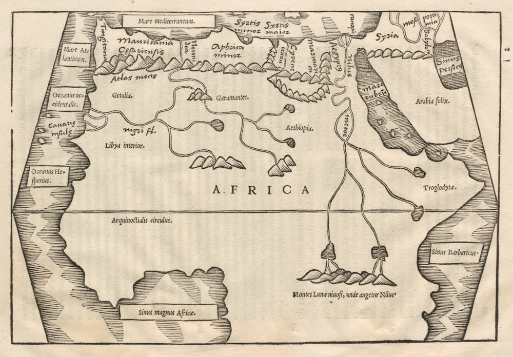
Description
First edition of this important work. A pristine offprint of the woodblock. Excellent collector's condition.
It is Sebastian Münster's earliest map of Africa, predating his map of the continent of Africa of 1540.
The geography is mostly Ptolemaic, with the Niger flowing west and the sources of the Nile located in the mountains of the moon. It uses Ptolemy's trapezoid projection.
The work was published in 1538 by Heinrich Petri, foremost printing-house in Basle. The text was edited and corrected by Sebastian Münster, professor in Hebrew, Latin and Greek. He also produced the maps.
When teaching at the University of Heidelberg, Münster had also worked as press-corrector for Heinrich's father Adam Petri. In 1529 Münster accepted a position at the University of Basle. In 1529, soon after his move to Basel, he left the Franciscan Order and adhered to Lutheranism; and in the following year he married Adam Petri's widow, thus gaining for himself a measure of financial security and the services of the substantial printing-house of his stepson Heinrich Petri, who was to produce most of his later works.
A second edition of the work would appear in 1543, with different signatures for the maps.
Gaius Julius Solinus (3rd century A.D.)
GAIUS JULIUS SOLINUS, Latin grammarian and compiler, probably flourished during the first half of the 3rd century A.D. He was the author of Collectanea rerum memorabilium, a description of curiosities in a chorographical framework. Adventus, to whom it is dedicated, is identified with Oclatinius Adventus, consul A.D. 218. It contains a short description of the ancient world, with remarks on historical, social, religious and natural history questions. The greater part is taken from Pliny's Natural History and the geography of Pomponius Mela. According to Mommsen, Solinus also used a chronicle (possibly by Cornelius Bocchus) and a Chorographia pliniana, an epitome of Pliny's work with additions made about the time of Hadrian. Schanz, however, suggests the Roma and Pratum of Suetonius. The Collectanea was revised in the 6th century under the title of Polyhistor (subsequently taken for the author's name). It was popular in the middle ages, hexameter abridgments being current under the names of Theodericus and Petrus Diaconus.
The commentary by Saumaise in his Plinianae exercitationes (1689) is indispensable; best edition by Mommsen (1895), with valuable introduction on the MSS., the authorities used by Solinus, and subsequent compilers. See also Teuffel, Hist. of Roman Literature (Eng. trans., 1900), 389; and Schanz, Geschichte der romischen Litteratur (1904), iv. 1. There is an old English translation by A. Golding (1587).
(Encyclopedia Britannica).
"Caius Julius Solinus was a Roman who lived in the third or fourth century AD, possibly worked as a grammarian, and is most widely recognized for his work, the Polyhistor. Possibly written sometime in the middle of the third century, the Polyhistor, alternatively known as the Collectanea rerum memorabilium and De situ orbis, relied heavily on Pliny's Natural History as well as Pomponius Mela's De situ orbis. The work touches on the natural history and geography of the regions known to the Roman Empire, as well as religious and social matters. Solinus's Polyhistor remained popular through the Middle Ages and Renaissance, particularly for its geographical content. The Polyhistor was first translated into English in 1587 by Arthur Golding."
(Clements Library)
Sebastian Münster (1489-1552)
Following the various editions of Waldseemüller's maps, the names of three cartographers dominate the sixteenth century: Mercator, Ortelius and Münster, and of these three Münster probably had the widest influence in spreading geographical knowledge throughout Europe in the middle years of the century.
His Cosmographia, issued in 1544, contained not only the latest maps and views of many well-known cities, but included an encyclopaedic amount of detail about the known - and unknown - world and undoubtedly must have been one of the most widely read books of its time, going through nearly forty editions in six languages.
An eminent German mathematician and linguist, Münster became Professor of Hebrew at Heidelberg and later at Basle, where he settled in 1529. In 1528, following his first mapping of Germany, he appealed to German scholars to send him "descriptions, so that all Germany with its villages, towns, trades, etc. may be seen as in a mirror", even going so far as to give instructions on how they should "map" their own localities. The response was far greater than expected and such information was sent by foreigners as well as Germans so that, eventually, he was able to include many up-to-date, if not very accurate, maps in his atlases.
He was the first to provide a separate map of each of the four known Continents and the first separately printed map of England. His maps, printed from woodblocks, are now greatly valued by collectors. His two major works, the Geographia and the Cosmographia were published in Basle by his step-son, Henri Petri, who continued to issue many editions after Münster's death of the plague in 1552.
(Moreland & Bannister).
The remaining modern maps, [...], are all drawn on a plane projection, undergraduated, without scales, and variously oriented with north, south, east or west at the top, "without the excuse of topographical necessity", as Nordenskjöld severely remarks. In spite of these and other cartographic defects, they constitute an important corpus of geographical knowledge and interpretation; Münster was the first atlas-maker to furnish separate maps of the four continents then known; and for England, Scandinavia and southern Germany, eastern Europe and America he brought recent and significant representations into general currency.
(Skelton).
The Cosmographia of Sebastian Münster must rank as the greatest geographical compendium of the period - an immensely detailed work illustrated with woodcut portraits, scenes, town plans and panoramas, and maps. Born in 1488, Münster was a Fransiscan who became Professor of Hebrew at Heidelberg and later at Basle, where he taught Hebrew and, amongst other works, published the first German translation of the Bible from Hebrew. In 1540 his edition of Ptolemy's Geographia was published, followed in 1544 by the Cosmographia Universalis. Together these ran to over 35 editions published mostly in Basle in Latin, German, French and Italian versions. Münster's particular cartographic importance lies in the number of 'new' maps he introduced and, above all, in the innovative, separate mapping of each of the four continents. The map of the Americas is not only the first map to show the Western Hemisphere separately, but is also the first to show North and South America joined together.
(Potter p38).
Sebastian Münster was raised as a Franciscan monk, converted to Lutheranism, taught Hebrew at Heidelberg and Basle, and was proficient in Greek and some Asian tongues. He died of the plague in 1552. First published in 1540, his atlas was the first to contain separate maps of each of the four continents.
(Suárez).
In 1540 Sebastian Münster, who was to become one of the most influential cartographers in the sixteenth century, published his edition of Ptolemy's Geographia with a further section of modern, more up-to-date maps. He included for the first time a set of continental maps, the America was the earliest of any note. Münster studied Hebrew at Heidelberg and was a scholar of geography, writing amongst other works the Polyhistor.
He was one of the first to create space in the woodblock for the insertion of place-names in metal type. The map's inclusion in Münster's Cosmography, first published in 1544, sealed the fate of "America" as the name for the New World. The book proved to be very popular, there being nearly forty editions during the following 100 years.
(Burden).
Claudius Ptolemy (c.100 - c.170)
Ptolemy, Latin in full Claudius Ptolemaeus was an Egyptian astronomer, mathematician, and geographer of Greek descent who flourished in Alexandria during the 2nd century AD. In several fields his writings represent the culminating achievement of Greco-Roman science, particularly his geocentric (Earth-centred) model of the universe now known as the Ptolemaic system.
Virtually nothing is known about Ptolemy’s life except what can be inferred from his writings. His first major astronomical work, the Almagest, was completed about 150 ce and contains reports of astronomical observations that Ptolemy had made over the preceding quarter of a century. The size and content of his subsequent literary production suggests that he lived until about 170 AD.
Astronomer
The book that is now known as the Almagest (from a hybrid of Arabic and Greek, “the greatest”) was called by Ptolemy Hē mathēmatikē syntaxis (“The Mathematical Collection”) because he believed that its subject, the motions of the heavenly bodies, could be explained in mathematical terms.
Mathematician
Ptolemy has a prominent place in the history of mathematics primarily because of the mathematical methods he applied to astronomical problems. His contributions to trigonometry are especially important. For instance, Ptolemy’s table of the lengths of chords in a circle is the earliest surviving table of a trigonometric function. He also applied fundamental theorems in spherical trigonometry (apparently discovered half a century earlier by Menelaus of Alexandria) to the solution of many basic astronomical problems.
Among Ptolemy’s earliest treatises, the Harmonics investigated musical theory while steering a middle course between an extreme empiricism and the mystical arithmetical speculations associated with Pythagoreanism. Ptolemy’s discussion of the roles of reason and the senses in acquiring scientific knowledge have bearing beyond music theory.
Geographer
Ptolemy’s fame as a geographer is hardly less than his fame as an astronomer. Geōgraphikē hyphēgēsis (Guide to Geography) provided all the information and techniques required to draw maps of the portion of the world known by Ptolemy’s contemporaries. By his own admission, Ptolemy did not attempt to collect and sift all the geographical data on which his maps were based. Instead, he based them on the maps and writings of Marinus of Tyre (c. 100 ce), only selectively introducing more current information, chiefly concerning the Asian and African coasts of the Indian Ocean. Nothing would be known about Marinus if Ptolemy had not preserved the substance of his cartographical work.
Ptolemy’s most important geographical innovation was to record longitudes and latitudes in degrees for roughly 8,000 locations on his world map, making it possible to make an exact duplicate of his map. Hence, we possess a clear and detailed image of the inhabited world as it was known to a resident of the Roman Empire at its height—a world that extended from the Shetland Islands in the north to the sources of the Nile in the south, from the Canary Islands in the west to China and Southeast Asia in the east. Ptolemy’s map is seriously distorted in size and orientation compared with modern maps, a reflection of the incomplete and inaccurate descriptions of road systems and trade routes at his disposal.
Ptolemy also devised two ways of drawing a grid of lines on a flat map to represent the circles of latitude and longitude on the globe. His grid gives a visual impression of Earth’s spherical surface and also, to a limited extent, preserves the proportionality of distances. The more sophisticated of these map projections, using circular arcs to represent both parallels and meridians, anticipated later area-preserving projections. Ptolemy’s geographical work was almost unknown in Europe until about 1300, when Byzantine scholars began producing many manuscript copies, several of them illustrated with expert reconstructions of Ptolemy’s maps. The Italian Jacopo d’Angelo translated the work into Latin in 1406. The numerous Latin manuscripts and early print editions of Ptolemy’s Guide to Geography, most of them accompanied by maps, attest to the profound impression this work made upon its rediscovery by Renaissance humanists.
(Britannica)