Leen Helmink Antique Maps & Atlases
www.helmink.com
Tallis
United States
Certificate of Authentication and Description
This is to certify that the item illustrated and described below is a genuine antique
map, print or book that was first produced and published in 1851, today 175 years ago.
July 14, 2026
Cartographer(s)
Tallis
First Published
London/New York, 1851
This edition
1851
Size
24.5 x 34 cms
Technique
Steel engraving
Stock number
18921
Condition
excellent
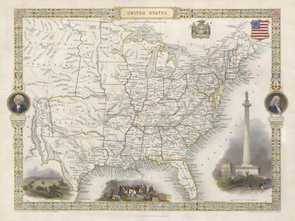
Description
"United States", steel engraving by John Rapkin, published by John Tallis, London, 1851.
With three decorative vignette views labeled
- Washington's Monument (includes the statue at the top which was never installed)
- Penn's Treaty with the Indians
- Buffalo Hunt
A great map of the eastern states and some very interestingly shaped western territories up to about the Rocky Mountains.
Portraits of Washington and Franklin are shown in the left and right decorated border, as well as two US seals.
Original hand color. Ample margins. A very handsome example of this important collector's map.
"John Tallis' Illustrated Atlas reflects a movement away from the sombre scientific style that so typified early nineteenth-century mapmaking. Published to commemorate the Great Exhibition of 1851, Tallis' beautiful maps, engraved on steel by John Rapkin, reflects the glories of Britain's world empire and provide a pastiche of images of far-flung corners of the world available for the first time to the Victorian armchair traveller."
(Barron).
"All the maps and plans have ornamental borders and most have vignette scenes; they are invariably described as 'the last decorative series of maps ...'. "
"Another series, which is especially popular for its decorative borders and vignette scenes, is that by John Tallis published in London and New York."
(Potter).
"Frequently referred to as 'the last decorative series of maps', these are attractively designed, informative pieces which combine the best elements of scientific cartography and decorative art as the great early mapmakers did. The decorative borders and attractive vignette scenes contrasted vividly with the austere approach of many other comparable atlas publishers of the time, whose use of decoration was negligible although the cartographic quality of their output was undoubted."
(Potter/Martin).
"... the last pictorial maps in the old tradition."
(Tooley & Bricker).
"The Illustrated Atlas presents a vivid and fascinating portrait of the nineteenth century world. Its main features were accurate, detailed and beautifully coloured maps; charming vignettes depicting cities, people and natural wonders of each country; informative passages by Montgomery Martin of facts and figures for every map compiled from the eye-witnessv accounts of explorers and a variety of authorative sources."
(Potter).
What follows is the original 1851 Montgomery Martin text that accompanies this map:
UNITED STATES
AREA AND PHYSICAL ASPECT
It is obviously impossible to describe the physical aspect of so vast a country (1,300,000 square miles) in any detail in a limited space, but a few general statistics may assist in illustrating the chief points. Generally speaking the United States territories consist of extensive natural forests, interspersed with open plains termed prairies. The whole country is well watered and presents considerable variety of soil and climate. The longest rivers are the Missouri, the Mississippi and the Arkansas, and even the smaller rivers are navigable for many miles for sloops, etc. Many of the principal mountains are over 4,000 feet high, and Mount Washington in New Harnpshire is 6,230 feet. The climate is, of course, influenced by the degree of distance from the equator, but it is much colder in North America than in the same latitude in Europe.
HISTORY
Whether America was known to the ancients is a subject of dispute among scholars, although it is highly probable that the Northmen of Europe landed there five centuries before the discoveries of Columbus. A Runic inscription still exists in Naraghansett Bay. After the voyages of Columbus and Cabot in 1492 and 1497, Spain devoted its attentions to developing the central and southern portions of America, while Queen Elizabeth directed the resources of England to the north. After early failures several colonies were formed on various parts of the coast, either by enterprising individuals or by associations both religious and commercial. Apart from the English, the Dutch, Swedes, Finns and other Europeans also formed settlements. In 1776 the thirteen colonies declared their independence and constituted themselves the United States of America, since which time several other states have been added, the total now numbering 26 states and 5 territories.
POPULATION
During the 50 years from 1790 to 1840 the population increased over fourfold and it is estimated that the total is now probably 25,000,000, with a further 313,000 Indians living mostly between the Mississippi and the area west of the Rocky Mountains. The largest concentrations of people live in the eastern states. Altogether there are around 400,000 free coloured people and great numbers of slaves, most of them in the southern states. In 1850 Virginia alone had 473,972 slaves, South Carolina, 384,720, and their numbers are still increasing. In 1840 the proportion of free persons to 1 slave throughout all the states was 5.86, and Massachusetts, Maine, Vermont and Michigan were the only states without slaves. There is no state religion and all forms of Christian worship are protected. Generally speaking the people are religieus, but much split into sects.
GOVERNMENT
Each state has its own constitution, executive and legislative department and a governor who is elected in some cases by the people, in others by the legislature. The central Congress, which has its seat at Washington, consists of two houses and a President. The members of the two houses are representatives of the states. In the eastern and middle states the suffrage is almost universal, and throughout the Union voting by ballot prevails.