Leen Helmink Antique Maps & Atlases
www.helmink.com
Waghenaer
The Mariners Mirrour (Speculi Marini)
Certificate of Authentication and Description
This is to certify that the item illustrated and described below is a genuine antique
map, print or book that was first produced and published in 1584, today 442 years ago.
July 14, 2026
Cartographer(s)
Waghenaer
First Published
Leiden, 1584
This edition
Amsterdam, 1591
Size
31 x 23 cms
Technique
Copper engraving
Stock number
18913
Condition
excellent
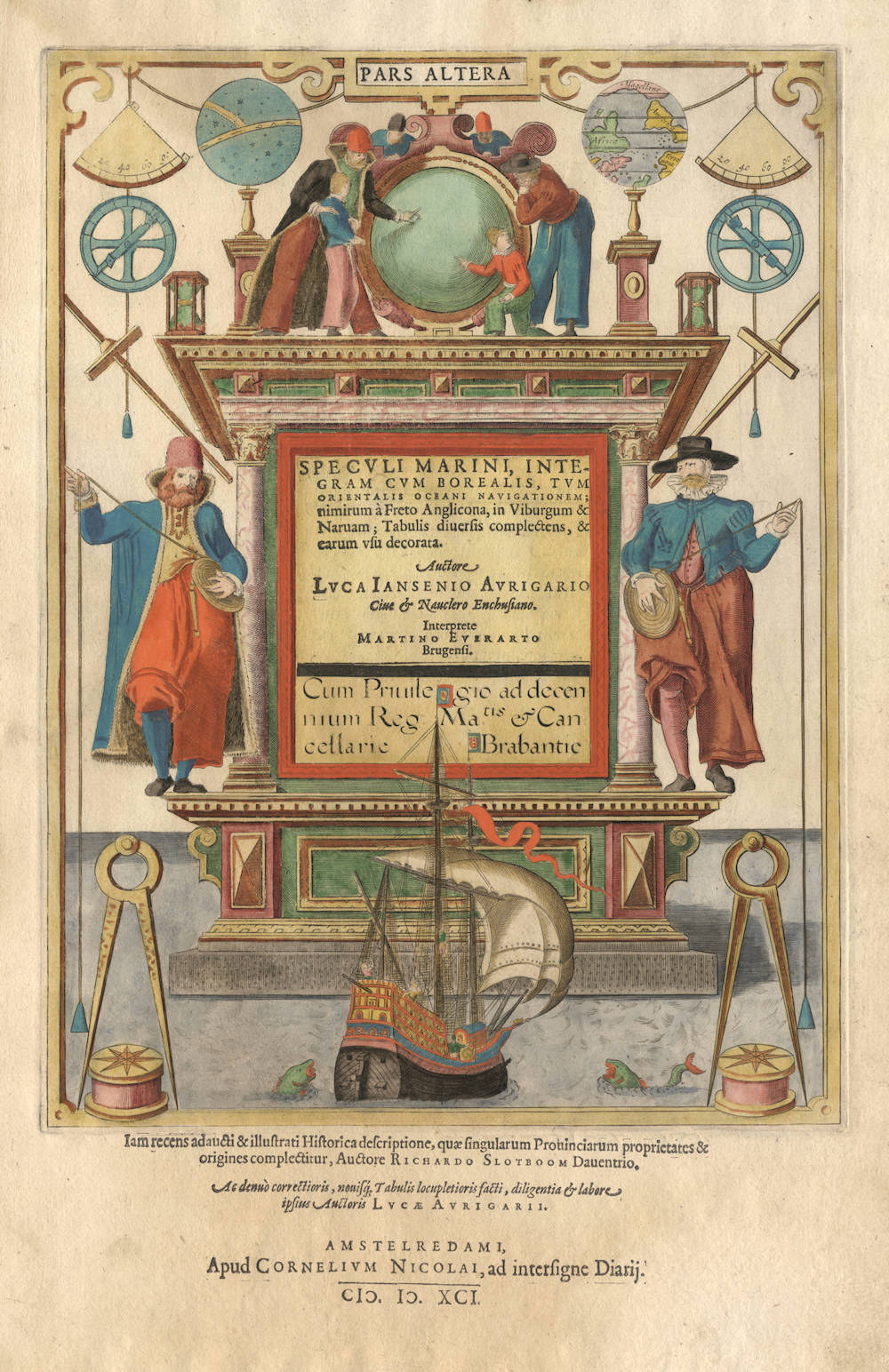
Description
In 1584 Lucas Janszoon Waghenaer published the first atlas of printed sea charts from Leiden in the Netherlands. It was titled De Spieghel der Zeevaerdt (A Mirror for Sea-farers) and covered the coasts and waters of northern and western Europe. The Spieghel was deemed so important for navigation that the whole work was pirated and translated into English (from the Latin-text edition of 1586) for publication in England in 1588, the year of the Spanish Armada.
A heavy architectural structure is placed as if floating on a calm sea. Two hatted and clothed seaman stand somewhat precariously on the edge of this platform, both of them casting a leaden weight and line for depth measuring purposes. Beneath them is a fully-rigged ship of the period, two dividers and two box compasses. In the space above them are pairs of cross-staffs, simple astrolabes, quadrants and hour-glasses; also celestial and terrestrial globes—the latter for some reason inverted. In the centre, in place of a pediment a cluster of seamen, including a young boy, gather around a large mirror.
Waghenaer's titlepage is of special interest as it clearly depicts all the instruments mariners made practical use of at sea. At the time, with little else to guide them apart from uncertain records of past experience and perhaps a set of hand-drawn charts (of doubtful accuracy), mariners circumnavigated the globe and voyaged into unknown parts of the world.
As Günter Schilder says in Monumenta Cartographica Neerlandica, Vol VII, Waghenaer's work was a milestone in the development of West European navigation. His charts brought together the pictorial silhouettes that had been a standard feature of traditional rutters used by pilots, and combined these with updated coastal outlines. In addition there were compass roses and lines of navigational direction, as well as soundings to help navigators make their way into ports and havens. Initially the publication was handled by the firm Christopher Plantin with the notable artist Joannes van Doetecum commissioned to engrave the plates. Later, from 1589, the publishing house Cornelis Claesz obtained the publication rights which were cooperatively exercised in conjunction with the firm Jean Bellere from Antwerp.
(Shirley)
Lucas Janszoon Waghenaer (c.1534-1598)
By the third quarter of the sixteenth century an ever increasing volume of the wealth of the New World and the Indies was reaching Lisbon and the Spanish porte there to be trans-shipped to Northern and Western Europe. This trade was almost entirely in the hands of the Dutch so it was logical that one of their pilots should produce the first set of effective navigational charts. These were compiled under the title Spiegel der Zeevaerdt, by Lucas Janszoon Waghenaer, a native of Enkhuizen on the Zuider Zee, an experienced seaman and pilot. His magnificently produced charts embodying all the latest contemporary knowledge of navigation and position-finding set a standard which was followed by others for the next century or more – indeed, some of the symbols employed are still in use today.
The charts in the first edition, covering the coast lines from Holland to Spain and the North Sea and Baltic, were engraved by the van Doetecum brothers and printed by Plantin: those in the English edition, which was translated by Sir Anthony Ashley and issued in 1588 – the year of the Armada – were engraved by de Bry, Hondius, Rutlinger and Ryther, who also engraved some of Saxton's maps. The charts are extremely picturesque with elaborate cartouches, ships in full sail and the sea monsters so commonly used as decoration in maps of the period. Place names are given on the coasts but comparatively few are shown inland; cliffs on the coastline are drawn in elevation; navigational landmarks and hazards, anchorages, soundings and tidal details are indicated and the scale is shown in English, Spanish and Dutch leagues. Altogether some of the most handsome maps ever produced.
The charts became so universally popular that their name, anglicized to 'Waggoner', came into use in English as a generic term for sea charts of all kinds.
(Moreland and Bannister)