Leen Helmink Antique Maps & Atlases
www.helmink.com
Carel Allard
Potosi
Certificate of Authentication and Description
This is to certify that the item illustrated and described below is a genuine antique
map, print or book that was first produced and published in 1695, today 331 years ago.
July 13, 2026
Cartographer(s)
Carel Allard
First Published
Amsterdam, 1695
This edition
1695 first edition
Size
21.2 x 27.0 cms
Technique
Copper engraving
Stock number
18907
Condition
excellent
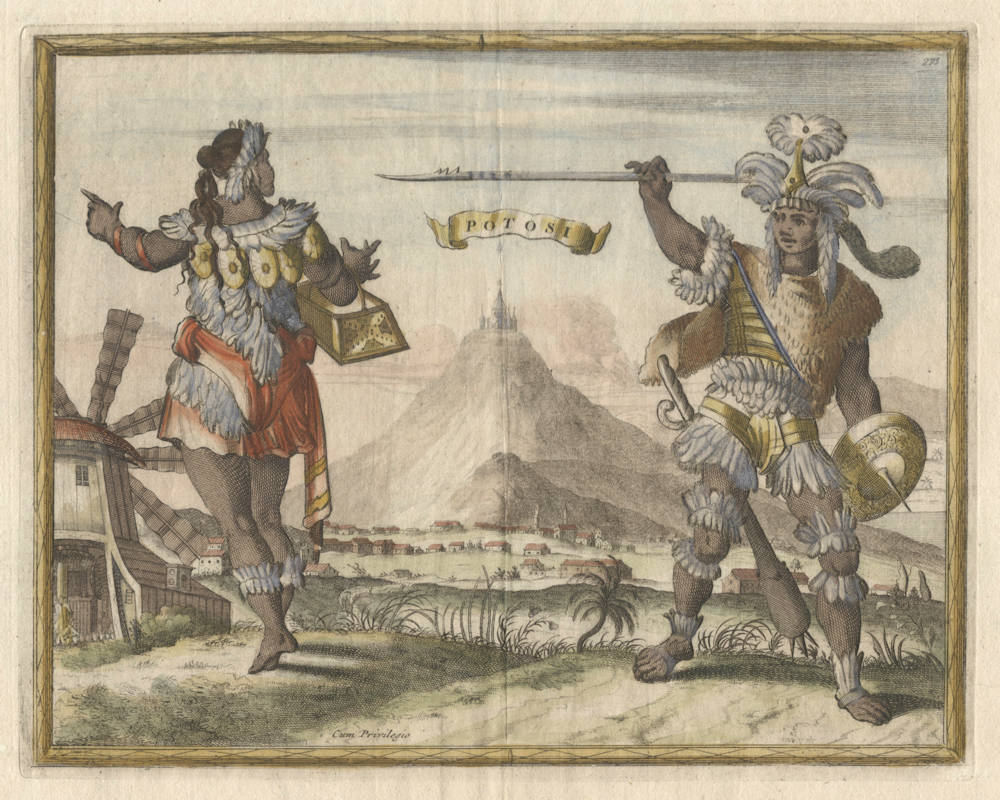
Description
Exceptionally rare costume view of the city and of
The mountain was conceived to be made of silver ore and was the major supply of silver for the Spanish Empire. From 1572-1767, Potosi was the location of the Spanish colonial silver mint. The silver had to be coinaged into Spanish dollars, known as pieces of eight (Reale de a ocho or Peso), the first international currency that was used and accepted world wide.
The Spanish dollar was the coin upon which the original United States dollar was based, and it remained legal tender in the United States until the Coinage Act of 1857. Because it was widely used in Europe, the Americas, and the Far East, since the early 1500s, it became the first official world currency by the late 18th century. Aside from the U.S. dollar, several other currencies, such as the Canadian dollar, the Japanese yen, the Chinese yuan, the Philippine peso, and several currencies in the rest of the Americas, were initially based on the Spanish dollar. Diverse theories link the origin of the "$" symbol to the columns and stripes that appear on one side of the Spanish dollar.
Carel Allard (1648-1709)
CAREL ALLARD (1648 - 1709) was the elder son of Hugo or Huych Allard, an Amsterdam cartographer and mapseller with a shop ‘op den Dam'. From about 1645 Hugo was actively engaged in the production of printed sheet-maps, although he never published an atlas (the British Museum catalogues an atlas of 29 maps by him (Maps 39. f. 3), but examination of its history proves this collection to be an 'atlas factice'). Some years before his death in 1691, the business seems to have been taken over, at the same address, by his son and partner Carel, who on in October 1683 obtained a 15-years' copyright privilege from the States of Holland and West Friesland for unspecified 'maps, towns, portraits, and prints of all kinds' already published by him or to be published in the future. The miscellaneous character of Carel Allard's output as a 'kunstvercooper', implied by the terms of the privilege, is illustrated by inventories of his plates drawn up towards the end of his career, in 1706 and 1708. The maps which formed a substantial part of it were thought well of by J. G. Gregorii (1713), who considered Allard 'a skilful artist', but apparently more for the elegance of their design and illumination than for their scientific quality. The more discriminating Hauber (1724) and Hübner (1726) give no more than a passing mention to Allard and his maps.
After the expiration of his general privilege in 1698, Allard petitioned for its renewal in wider terms (the precise character of which is not clear), submitting the 'specification' of the maps for his Atlas Minor as a sample of his cartographic work. His application, twice made in 1699, was referred to members of the booksellers' guild as assessors, and their reports suggest that Allard did not enjoy particularly good repute in the print-trade. Examining the 'so-called (pretense) Atlas Minor’, as they contemptuously called it, they found that most of the maps to be included in it 'were made and published long ago, under privilege, by other print- and mapsellers’, and they noted that Allard had been in trouble both at Amsterdam and at Frankfurt (presumably at the book-fair) for distributing 'lewd and scurrilous drawings and prints'. Their recommendation was that the old privilege be renewed, but without the additional protection solicited by the applicant.
Before this, Allard seems to have embarked on the production of atlases and town-books. Their chronology is doubtful, all being undated. His Atlas Minor is usually ascribed by bibliographers, on internal evidence, to the year 1696; although the documents relating to the renewal of his privilege suggest that in 1699 it was still unpublished, there may have been an earlier edition. In 1707 two versions of Allard's Atlas Minor were advertised, the larger in two volumes with 260 plates, the smaller with 150 plates, besides his Atlas Major in three volumes with 521 plates. The contents of the Atlas Major exemplify his practice in atlas-construction, as observed by the assessors in 1699. Few of its maps were compiled or engraved by Allard or have his imprint; the majority are impressions of maps published by Visscher, Jansson and his successors, and De Wit. with some by Blaeu, Danckerts, Mortier, Schenk, Jaillot and others. Since the make-up of such an atlas depended on the mapseller's retail stock at the time of sale, it may be considered an 'atlas factice' notwithstanding its printed titlepages and tables of contents. A copy of the Atlas Major described by Tiele contained a map by Schenk dated 1705, so that it must have been on sale between that year and 1707. Allard's Magnum theatrum belli, of 57 maps, was constructed in the same way, drawing heavily on the production of Visscher and other publishers.
His book of towns and costumes, the Orbis habitabilis oppida et vestitus, is more homogeneous in character and personal in style. Although (as will be seen) its plates were largely — if not entirely - copied from earlier published work, there is little reason to doubt that its engravers worked under Allard's direction, if not in his shop, and that he imposed on the collection the unity and individuality which distinguish it. Pieter Schenk paid it the compliment of extensive plagiarism in his Hecatompolis sive ... oppida nobiliora centum (1702), copying from Allard's book no fewer than 47 views of towns and echoing its title in his own.
The publication date of the Orbis habitabilis oppida et vestitus is uncertain. We know only that (since 73 of its plates, including the engraved titlepage, bear the privilege statement) it must have come out between 1683, when Allard received his first privilege, and 1702, when Schenk produced his copies. Mrs LeGear (1958, describing Phillips 5385) supposes publication to have been before 1698, when the original privilege expired; but, as we have seen, the privilege appears to have been renewed in 1699, and later works by Allard, e.g. the Atlas Major, still carry the privilege statement. Hiler (1939), on the other hand, held the work to have been 'issued after 1700 and, it may be, as late as 1710', but without giving any reason. Of the two engravers who sign plates, Thomas Doesburgh is known to have been working 1683 - 1714, and Aldert Meijer 1686 - 88 (Waller 1938). The printed sources used for the views, such as the works by Olfert Dapper published in the 1670s, were mostly somewhat earlier. The likeliest date for the publication of Allard's town-book seems to be about 1695.
The typographic titlepage of the Orbis habitabilis oppida et vestitus names Carel Allard as compiler and editor, as well as publisher, of the collection; and his privilege is cited in the imprint. In the foreword in Latin and Dutch, Ludolph Smids (1649 - 1720), a Groningen physician and antiquary who had settled at Amsterdam in 1685, makes the customary claim that anyone using such a collection could, without leaving the comfort of his own study, 'travel the world on foot, on horseback, by coach, or by sea, discoursing with remote peoples, admiring their costumes and ornaments, their churches and buildings'. This is the keynote of the collection, already struck in its title. Curiously, Smids also signs the list of plates in Schenk's Hecatompolis (1702). In the long series of town-books, the illustration of topography and of social life had gone hand-in-hand ever since Georg Braun, the editor of the prototype, the Civitates orbis terrarum, had written in his foreword of 1572: 'We have introduced into the views of towns representations of the costumes of various nations'. This 'ethnographic' purpose, no doubt allied to a sense of pictorial effect, explains the figures or groups in national dress placed in the foreground of views and plans by Joris Hoefnagel and the other artists who, working in his convention, contributed to the Civitates and subsequent city-atlases. (Here, and in the similar vignettes engraved in the cartouches or margins of maps from Amsterdam workshops, we may suspect the influence of Dutch 'genre' painting). Carel Allard however was, so far as we know, the first editor of a town-book to couple topographical plates and corresponding costume-plates. In his collection, twenty-three of the subjects (making 46 plates) are represented by such pairs, the costumed figures in the second plate being backed, in all cases but three, by a reduced version of the same view as that presented, on a larger scale, in the first plate. Of the remaining 54 plates, 36 are views of towns, and 18 are costume pictures or characteristic 'genre' groups.
The 100 numbered plates are executed in a free style with noticeable bravura, using line-engraving and etching in combination. Of the costume-plates 36 are signed by Meijer, and the other five are almost certainly by him. Twenty views have Doesburgh's signature, and the remaining 39 are engraved in a style and with decoration indistinguishable from those of his signed plates.
For over two-thirds of the views, printed sources have been found without much difficulty, and it is probable that all were copied by Doesburgh from earlier engravings. Fourteen European views, together with one in Asia and one in America, are derived either from the collection Icones praecipuarum urbium totius Europae, published by Clement de Jonge in 1675, or from the closely similar (though more numerous) views in Frederik de Wit's Theatrum praecipuarum totius Europae urbium, undated but apparently of about 1690. For Asia, Africa and America the engraver of Allard's views drew heavily on the illustrated historical-geographical works of Olfert Dapper, published in the years 1670 - 73; these books supplied the models for four views in Persia, eight in Africa, and eleven in America. In copying 'Morocco' (Marrakech), Doesburgh mistakenly reversed the design, and he was followed in the error by Schenk's engraver. London is one of the three towns of which the view forming the background to the costume-plate differs from the larger view in the preceding plate; although both seem to be based on the same original, the larger view (like De Wit's) adds Wren's rebuilt, or projected, St Paul's and the Monument to the Great Fire.
The greater number of the costume-plates by Meijer are copies from a single source. This was a collection of 48 plates without title or date (Colas, no. 2480) by the Amsterdam engraver Johannes de Ram (1648 – 93), illustrating costumes of the world, with male and female figures paired on each plate against a topographical background. From this Meijer took no fewer than 34 of his designs. De Ram was a somewhat more original artist and publisher than Allard; his collection, which must have appeared before his death in 1693, seems to be the earliest in this form, depicting costumes of the whole world by pairs of figures; and it provided the model not only for Allard's plates but also for those etched by Caspar Luyken and published by Christoph Weigel at Nuremberg in 1703 under the title Neu-eröffnete Welt-Gallerie (Colas, no. 2189), with text by Abraham a Santa Clara.
It appears that after 1700 Allard's business did not prosper. His atlases seem to have had only limited success, no doubt (as suggested by Koeman 1961) because seventeenth-century cartography could no longer compete with the newer production of French workshops, which 'answered more effectively the demands for accuracy and modernity'; moreover, as recorded by Hübner (1726), German publishers were able to undercut the prices of the Dutch in the map-market. The evidence for the decline in Allard's affairs is to be found in documents printed by Kleerkooper and van Stockum (1914 - 16) and in an Amsterdam auction-catalogue analysed by Koeman (1961).
On 8 March 1706, Carel Allard conveyed to his sons Abraham and Hugo 'shop-goods', i.e. stock in trade, of a value equivalent to the patrimony to which they were entitled under a deed executed by him on 7 July 1683, two days before his second marriage, when they were still under age. Among the engraved plates in the stock thus transferred are listed some which can probably be identified with those of the Orbis habitabilis oppida et vestitus, namely, '56 steden', '40 dragten', and 'I titel tot het Stedeboek van 100'. On 7 August 1708 a quantity of maps and atlases by Amsterdam publishers (estimated by Koeman at no fewer than 10.000 sheets) were sold by auction in Jan Needer's rooms; among them are catalogued the 'Stedeboek van 100 steden en Dragten, in folio, C. Allard', besides his Atlas Major, Atlas Minor and 'Tooneel des Oorlogs'. Koeman suggests, with some reason, 'that we have to do here with the sale of the surplus stock of the publisher Carel Allard'. By this time Allard was in financial difficulties, of which Needer's sale was perhaps a consequence; for only a month later, on 7 September 1708, an inventory of the copper plates held by 'the administrator of the bankrupt shop (curateur over den insolventen boedel) of Carel Allard' was drawn up at the instance of the administrator himself and of Abraham Allard, who presumably wished to safeguard his own property from his father's creditors.
In 1709 Carel Allard died. Although Abraham remained in business as a map-engraver and publisher until his own death in 1725, many of his father's plates came into the possession of the Leiden publisher Pieter van der Aa. Those of the agreeable, if not very original, book of towns and costumes seem to have made in 1710, one more separate appearance over Van der Aa's imprint, if we suppose that they formed the nucleus of a collection recorded by bibliographers (but not seen by the present author) under the title Habillemens de plusieurs Nations, representez au naturel, en cent trente-sept belles figures (Colas, no. 1367). The plates were used for the last time, with plate-numbers deleted, in the vast corpus of prints published by Van der Aa in 1729 as La Galerie Agréable du Monde.
(R.A. Skelton)