Leen Helmink Antique Maps & Atlases
www.helmink.com
de Jode
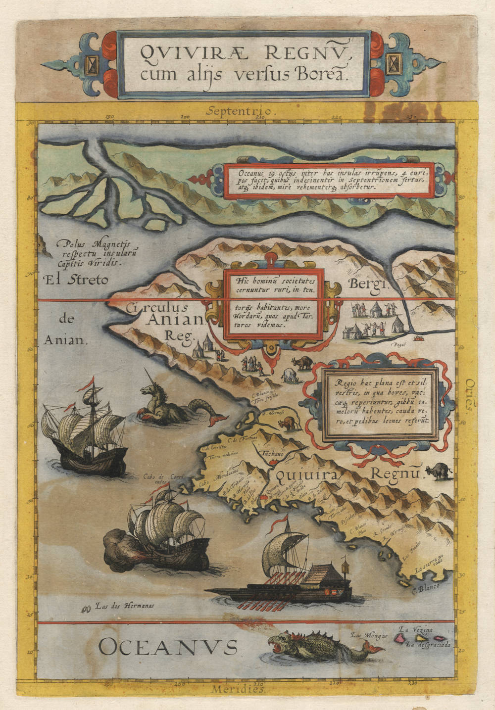
Quivirae Regnu, cum alijs versus Borea.
Certificate of Authentication and Description
This is to certify that the item illustrated and described below is a genuine antique
map, print or book that was first produced and published in 1593, today 433 years ago.
July 31, 2026
Cartographer(s)
de Jode
First Published
Antwerp, 1593
This edition
1593 first and only edition
Size
35.0 x 24.5 cms
Technique
Copper engraving
Stock number
18902
Condition
some color offsetting, excellent
Description
Cornelis de Jode's epic map of the westcoast of North America, from latitude 30 degrees N all the way to latitude 90 degrees N, close to the North Pole. The map covers all of today's western US, western Canada and Alaska. The Tropic of Cancer (latitude 23 degrees 26') is given near the bottom of the map, and the Arctic Circle (latitude 66 degress 33') is present also, about two-thirds up the map.
This is the first map dedicated to this region, and it is a fascinating amalgamation of Marco Polo's account of his travels to China, and the early California coast explorations of the Spanish Pacific explorers, up to and beyond C. de S. Francisco and Mendocino. The Sierra Nevada (Snowy Mountains) is noted, first named in 1542 by Juan Rodriguez Cabrillo for one of the few inland features that could clearly be seen from the Spanish explorers ships.
America is separated from Asia by the undiscovered but correctly assumed El Streto de Anian (Anian Strait), a hypothesis first introduced by Giacomo Gastaldi and later adopted by Gerard Mercator.
The Arctic islands in the far north also go back to Mercator, who relied on a famous but lost work of the 1360s known as Inventio Fortunata, containing a description of the North Pole as a magnetic island surrounded by a giant whirlpool and four islands. The book was a travel account by a Franciscan friar from Oxford who made half a dozen of journeys to the far north on behalf of the King of England (Edward III). The Inventio had already gone missing in Mercator's days, but he had access to a summary of it by Jacob Cnoyen, a traveller from Brabant, as Mercator writes in a letter to the English astronomer John Dee in 1577. The Cnoyen summary also went missing soon after.
In the upper left is a rock representing the Magnetic Pole, which explains the deviation of the compass. It "respects the Cape Verdian Islands", where the deviation was known to be zero, meaning the magnetic pole had to be on the same or opposite meridian.
Two sea monsters are in the Pacific, as well as a galley and two caravels, copied after designs by Pieter Bruegel the Elder.
Interestingly, the tent dwellers depicted inland are probably the first printed depiction of north American natives in this part of the world.
"Like the Americae Pars Borealis this single sheet map is largely derived from the eighteen sheet world map by Petrus Plancius of 1592. It is the first published map devoted to the west and north-west coasts of North America, and comes from de Jode's very rare atlas entitles Speculum Orbis Terrae.
It depicts the west coast from below the Tropic of Cancer to the North Pole here represented by the top border of the map. Part of the four islands derived from Mercator surrounds the pole. Belows this runs the western end of the North West Passage leading into the El Streto de Anian. At this point we find the legend Polus Magnetis respectu insularu Capitis Viridis, and early indication of the magnetic pole. The map couples perfectly with the map Americae Pars Borealis to complete the coverage of North America. The inland details largely reflect the extent of various beliefs and legends that existed at the time; only part of the coastline records first hand knowledge. It is beautifully adorned with mythical sea creatures and ships.
Being issued in only one edition the map is very rare. There is only one known state of it."
(Burden 82).
Van der Krogt 3 - 9190:32.
Gerard de Jode (c.1509-1591)
Cornelis de Jode (son) (1568-1600)
Gerard de Jode originally issued his atlas in 1578 to compete with Ortelius' atlas with little success. In 1593, two years after his death, Gerard's son Cornelius re-issued the atlas. The success of the atlas was very limited due to heavy competition with Ortelius, who also seems to have bought many copies of de Jode's atlas to take them off the market. Because of this, both editions of the de Jode atlas are exceptionally rare.
"Gerard de Jode, born in Nijmegen, was a cartographer, engraver, printer and publisher in Antwerp, issueing maps from 1555 more or less in the same period as Ortelius. He was never able to offer very serious competition to his more businesslike rival although, ironically, he published Ortelius's famous 8-sheet World Map in 1564. His major atlas, now extremely rare, could not be published until 1578, eight years after the 'Theatrum', Ortelius having obtained a monopoly for that period.
The enlarged re-issue by his son in 1593 is more frequently found. On the death of Cornelis, the copper plates passed to J.B. Vrients (who bought the Ortelius plates about the same time) and apparently no further issue of the atlas was published."
(Moreland & Bannister).
"After the death of Cornelis in 1600, the copper-plates came into the hands of Jan Baptiste Vrients, then the publisher of Ortelius' Theatrum. Apparantly Vrients must have bought them to prevent any further publication of the Speculum."
(Koeman)