Leen Helmink Antique Maps & Atlases
www.helmink.com
Mercator / Ptolemy
Tab. II. Europae, Hispaniam ac Lusitaniam Complectens. (EUROPAE II TAB:)
Certificate of Authentication and Description
This is to certify that the item illustrated and described below is a genuine antique
map, print or book that was first produced and published in 1578, today 448 years ago.
July 17, 2026
Cartographer(s)
Mercator / Ptolemy
First Published
Duisburg, 1578
This edition
1695
Size
34 x 44 cms
Technique
Copper engraving
Stock number
18897
Condition
mint
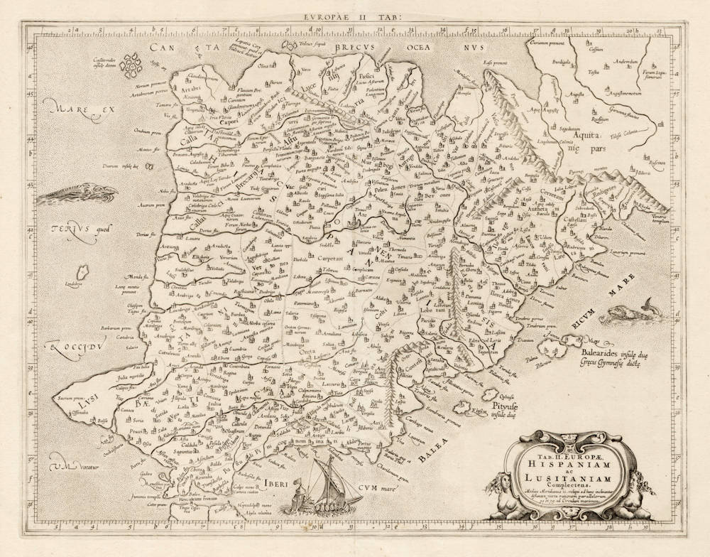
Description
Gerard Mercator's version of Ptolemy's map of Spain and Portugal. State 2, with a new title cartouche.
Claudius Ptolemy was librarian of the famous library of Alexandria and he had developed these maps for his "Geographia" around 150 AD and they reflect the best Roman geographical knowledge.
The work was rediscovered in the 15th century and the maps were reissued in the sixteenth and 17th century. The versions by the great cartographer Gerard Mercator are generally considered the most decorative and most skillful rendering of Ptolemy maps.
"Mercator’s edition of Ptolemy became the standard text; it was based on the best available sources, and all of its maps were re-edited and redrawn to conform to Ptolemy’s original design. As Shirley noted, “Mercator’s plates in his Geographia represent some of his best work and such was their excellence that seven further editions were printed from them.
Mercator in 1540 published Literarum latinarum, the first instructional handbook in the use of the italic hand to appear outside of Italy. It was also the first work to offer instruction in the use of italic script in the engraving of maps. The maps in Mercator’s Ptolemy are arguably the finest demonstrations Mercator provided in the use of italics. Moreover, “the beauty and legibility of the best sixteenth and severteenth-century Dutch maps can be traced in large measure to Mercator’s influence” (Karrow, p. 382)."
(Martayan Lan).
"The time and effort Mercator put into his revision of Ptolemy's Geographia was part of a grand scheme, occupying most of Mercator's life to describe the whole ancient and modern world geographically and historically.
Mercator's plates in his Geographia represent some of his best work and such was their excellence that seven further editions were printed from them. The initial plate, unaltered, was used for editions from Cologne in 1584, Frankfurt and Amsterdam in 1605, and from Leiden and Amsterdam in 1618–19. For the later editions from Franeker and Utrecht in 1695 and 1698, from Leiden, Amsterdam and Utrecht in 1704 and from Amsterdam in 1730 the plate was reworked."
(Shirley 139 on the world map).
"The work was rediscovered in the 15th century and the maps were reissued in the sixteenth and 17th century. The versions by the great cartographer Gerard Mercator are generally considered the most decorative and most skillful rendering of Ptolemy maps."
(van der Krogt [0902:1.2]
"Coloniæ Agrippinæ 1578. Fol. Tabula Geooraphicæ Cl. Ptolemaei ad mentem autoris restitute et emendata per Gerardum Mercatorem Illustriss: Ducis Clivia etc. Cosmographum.
This edition, the first with Mercator's series of maps, contains only the 27 old maps of Ptolemy in double folio, and a smaller one of the Delta of Nile. All the maps are printed from plates engraved in a masterly style by Gerard Mercator. This edition does not contain the text of Ptolemy, but extensive explanations of the modifications introduced in the accepted Ptolemaic types are printed on the reverse of the maps. An elaborate index of the 7,000 names in Ptolemy's geography concludes the work."
(Nordenskiöld 35).
Gerard Mercator (Kremer) 1512-1594
Arnold Mercator (son) 1537–1587
Rumold Mercator (son) c. 1545– c. 1599
Bartholomeus Mercator (son) fl. 1540-1563
Gerard Mercator (grandson) c. 1563-1656
Joannes Mercator (grandson) c. 1562-1595
Michael Mercator (grandson) c. 1567–1600
For nearly sixty years, during the most important and exciting period in the story of modern map making, Gerard Mercator was the supreme cartographer, his name, second only to Ptolemy, synonymous with the form of map projection still in use today. Although not the inventor of this type of projection he was the first to apply it to navigational charts in such a form that compass bearings could be plotted on charts in straight lines, thereby providing seamen with a solution to an age-old problem of navigation at sea.
His influence transformed land surveying and his researches and calculations led him to break away from Ptolemy conception of the size and outline of the Continents, Drastically reducing the longitudinal length of Europe and Asia and altering the shape of the Old World as visualized in the early sixteenth century.
Mercator was born in Rupelmonde in Flanders and studied in Louvain under Gemma Frisius, Dutch writer, astronomer and mathematician. He established himself there as a cartographer and instrument and globe maker, and when he was twenty-five drew and engraved his first map (of Palestine) and went on to produce a map of Flanders (1540) supervising the surveying and completing the drafting and engraving himself.
The excellence of his work brought him the patronage of Charles V for whom he constructed a globe, but in spite of his favour with the Emperor he was caught up in the persecution of Lutheran protestants and charged with heresy, fortunately without serious consequences. No doubt the fear of further persecution influenced his move in 15 s 2 to Duisburg, where he continued the production of maps, globes and instruments culminating in large-scale maps Europe (1954), the British Isles (1564) and the famous World Map on 18 sheets drawn to his new projection (1969). All these early maps are exceedingly rare, some being known by only one copy.
In later life he devoted himself to his edition of the maps in Ptolemy's Geographia, reproduced in his own engraving as nearly as possible in their original form, and to the preparation of his 3-volume collection of maps to which, for the first time, the word 'Atlas' was applied. The word was chosen, he wrote, 'to honour the Titan, Atlas, King of Mauritania, a learned philosopher, mathematician and astronomer'. The first two parts of the Atlas were published in 1583 and 1589 and the third, with the first two making a complete edition, in 1595, the year after Mercator's death.
Mercator's sons and grandsons, named above, were all cartographers and made their contributions in various ways to the great atlas. Rumold, in particular, was responsible for the complete edition in 1595. After a second complete edition in 1602, the map plates were bought in 1604 by Jodocus Hondius who, with his sons, Jodocus II and Henricus, published enlarged editions which dominated the map market for the following twenty to thirty years.
(Moreland & Bannister).
Claudius Ptolemy (c.100 - c.170)
Ptolemy, Latin in full Claudius Ptolemaeus was an Egyptian astronomer, mathematician, and geographer of Greek descent who flourished in Alexandria during the 2nd century AD. In several fields his writings represent the culminating achievement of Greco-Roman science, particularly his geocentric (Earth-centred) model of the universe now known as the Ptolemaic system.
Virtually nothing is known about Ptolemy’s life except what can be inferred from his writings. His first major astronomical work, the Almagest, was completed about 150 ce and contains reports of astronomical observations that Ptolemy had made over the preceding quarter of a century. The size and content of his subsequent literary production suggests that he lived until about 170 AD.
Astronomer
The book that is now known as the Almagest (from a hybrid of Arabic and Greek, “the greatest”) was called by Ptolemy Hē mathēmatikē syntaxis (“The Mathematical Collection”) because he believed that its subject, the motions of the heavenly bodies, could be explained in mathematical terms.
Mathematician
Ptolemy has a prominent place in the history of mathematics primarily because of the mathematical methods he applied to astronomical problems. His contributions to trigonometry are especially important. For instance, Ptolemy’s table of the lengths of chords in a circle is the earliest surviving table of a trigonometric function. He also applied fundamental theorems in spherical trigonometry (apparently discovered half a century earlier by Menelaus of Alexandria) to the solution of many basic astronomical problems.
Among Ptolemy’s earliest treatises, the Harmonics investigated musical theory while steering a middle course between an extreme empiricism and the mystical arithmetical speculations associated with Pythagoreanism. Ptolemy’s discussion of the roles of reason and the senses in acquiring scientific knowledge have bearing beyond music theory.
Geographer
Ptolemy’s fame as a geographer is hardly less than his fame as an astronomer. Geōgraphikē hyphēgēsis (Guide to Geography) provided all the information and techniques required to draw maps of the portion of the world known by Ptolemy’s contemporaries. By his own admission, Ptolemy did not attempt to collect and sift all the geographical data on which his maps were based. Instead, he based them on the maps and writings of Marinus of Tyre (c. 100 ce), only selectively introducing more current information, chiefly concerning the Asian and African coasts of the Indian Ocean. Nothing would be known about Marinus if Ptolemy had not preserved the substance of his cartographical work.
Ptolemy’s most important geographical innovation was to record longitudes and latitudes in degrees for roughly 8,000 locations on his world map, making it possible to make an exact duplicate of his map. Hence, we possess a clear and detailed image of the inhabited world as it was known to a resident of the Roman Empire at its height—a world that extended from the Shetland Islands in the north to the sources of the Nile in the south, from the Canary Islands in the west to China and Southeast Asia in the east. Ptolemy’s map is seriously distorted in size and orientation compared with modern maps, a reflection of the incomplete and inaccurate descriptions of road systems and trade routes at his disposal.
Ptolemy also devised two ways of drawing a grid of lines on a flat map to represent the circles of latitude and longitude on the globe. His grid gives a visual impression of Earth’s spherical surface and also, to a limited extent, preserves the proportionality of distances. The more sophisticated of these map projections, using circular arcs to represent both parallels and meridians, anticipated later area-preserving projections. Ptolemy’s geographical work was almost unknown in Europe until about 1300, when Byzantine scholars began producing many manuscript copies, several of them illustrated with expert reconstructions of Ptolemy’s maps. The Italian Jacopo d’Angelo translated the work into Latin in 1406. The numerous Latin manuscripts and early print editions of Ptolemy’s Guide to Geography, most of them accompanied by maps, attest to the profound impression this work made upon its rediscovery by Renaissance humanists.
(Britannica)